
PROPERTY OVERVIEW
|
LOCATION |
40 mi southeast of Fallon, NV |
|
TYPE OF PROJECT |
Early stage exploration |
|
NUMBER OF CLAIMS |
48 unpatented claims |
|
PROPETY SIZE |
̴ 960 ac. |
|
OWNERSHIP |
100% owned by Emgold |
|
PROPERTY STATUS |
Leased to Rawhide Mining LLC (“RMC”) |
|
UNDERLYING ROYALTIES |
None |
|
EXPLORATION COMPLETED |
|
|
KEY EXPLORATION TARGETS |
Toiyabe, Chicago Mountain/Gulch, Black Eagle, and North Buckskin Mountain |
|
NI 43-101 TECHNICAL REPORT |
None completed to date |
|
MINERAL RESOURCES |
None defined to date |
|
EXPLORATION HIGHLIGHTS |
|
INTRODUCTION
The Buckskin-Rawhide East Property (“Buckskin Rawhide East” or the “Property”) is an early stage gold and silver exploration property located in the Walker Lane Gold Belt in the Rawhide Mining District, Mineral County, Nevada. Gold was originally discovered at Rawhide, NV in 1906. In the 1980’s, Kennecott Exploration Company consolidated a land package that included the property that Emgold now calls Buckskin Rawhide East. In 1988, Kennecott Minerals Company developed the Rawhide Mine (aka Denton Rawhide Mine).
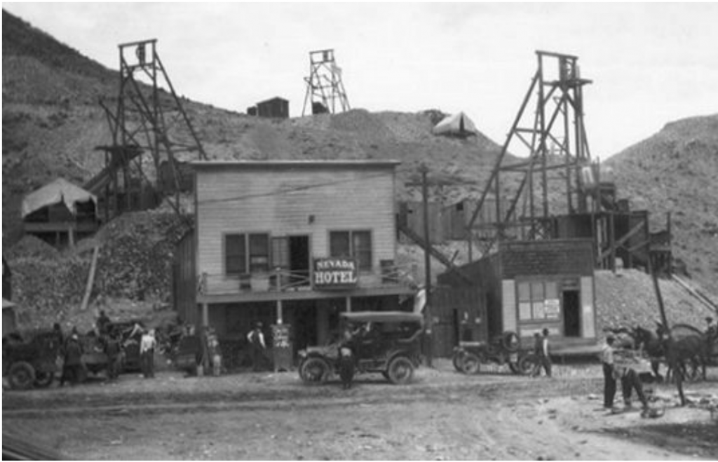
Town of Rawhide, NV, Circa 1915
Kennecott suspended mining operations at the mine in May 2003 due to low gold prices, but the mine continued to produce gold from existing heap leach pads. From 1990 through 2010, while operated by Kennecott, the Rawhide Mine produced 1.5 million ounces of gold and 12.4 million ounces of silver (Nevada Bureau of Mines). After shutting down operations, Kennecott reduced their land holdings, ultimately resulting in the formation of two adjacent properties – Buckskin Rawhide East that subsequently became owned by Emgold and the Regent Property that subsequently became owned by Pilot Gold Corporation (now called Liberty Gold Corporation (TSX: LDG)).
In 2010, the Rawhide Mine was acquired by RMC, a private company. They continued to produce gold and silver from the heap leach pads. In 2012, with rising gold prices RMC recommenced mining activities at Rawhide Mine. In 2013, RMC leased Buckskin Rawhide East from Emgold and acquired the Regent Property from Pilot Gold. This re-consolidated the land package formerly controlled by Kennecott. As a result, the Buckskin Rawhide East mineral claims have become “inlying” claims to the current Rawhide Mine Property.
In 2019, RMC completed a Plan of Operations and Environmental Assessment to expand its operations and mine from the Regent deposit located on the Regent Property. The Buckskin Rawhide East Property was also included in the Environmental Assessment, which allows exploration activities to occur on the Property subject to completion of certain site specific environmental studies. In 2019, RMC commenced production from the Regent Pit.
As of 2018, the latest available public data, Rawhide Mine has produced 1.7 million ounces of gold and 16.5 million ounces of silver (Nevada Bureau of Mines). In 2019, mining began from the recently permitted Regent deposit. RMC plans to ultimately explore for, and if successful, develop additional mineral resources on the Regent and Buckskin Rawhide East Properties, with the goal of extending the life of Rawhide Mine.
RMC has the right to acquire ownership of Buckskin Rawhide East by bringing it into commercial production. Upon reaching commercial production, Emergent's interest will convert into a royalty interest whereby Emgold will receive payments of US$15 per ounce of gold produced when the price of gold is above US$1,200 per ounce and up to US$1,799 per ounce of gold, with payments increasing to US$20 per ounce of gold produced when the gold price rises to or above US$1,800 per ounce of gold.
Note that there are currently no mineral resources or reserves delineated on the Property that meet NI 43-101 or CIM standards of disclosure. The proximity of the Property to adjacent operating mines does not guarantee exploration success, mineral resources or reserves will be defined, commercial production will be achieved, or royalty payments will be generated on the Property.
LOCATION & OWNERSHIP
The Buckskin-Rawhide East Property (“Buckskin Rawhide East” or the “Property”) is an early stage gold and silver exploration property located in the Walker Lane Gold Belt in the Rawhide Mining District, Mineral County, Nevada. It is located approximately 40 miles southeast of Fallon, NV.
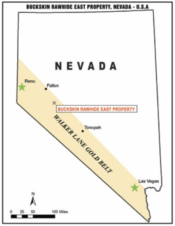
Buckskin Rawhide East Property
Location Map
Emgold optioned Buckskin Rawhide East in 2009. At that time, the Property consisted of 46 unpatented mineral claims which were leased through an agreement with Nevada Sunrise Gold Corporation (TSXV: NEV) (“Nevada Sunrise”). Nevada Sunrise had a 75 percent interest in 40 of the claims and a 100 percent interest in 6 of the claims. Nevada Sunrise also controlled the remaining 25 percent interest in the 40 claims through an underlying agreement with the Estate of Maurice and Lorraine Castagne. Emgold subsequently staked 6 additional claims, increasing the property size to 52 claims.
In 2013, Emgold acquired Nevada Sunrise’s interest in the 46 claims and subsequently acquired the remaining 25 percent interest in the 40 claims from the Estate of Maurice and Lorraine Castagne. Upon completion of the acquisition, Emgold held a 100 percent interest in the 52 unpatented mineral claims with no underlying royalty interests.
In 2012 and 2013, RMC completed a series of private placement into Emgold totalling US$1.0 million. Part of the proceeds from this private placement was used to acquire the Property from Nevada Sunrise and the Estate of Maurice and Lorraine Castagne. Upon completion of the series of private placements and acquisition of 100 percent Property by Emgold from the underlying owners, RMC leased the Property from Emgold, based on the following terms:
- A Lease Term is 20 years.
- Advance royalty payments will be $10,000 per year, paid by RMC to Emgold, with the first payment due at signing and subsequent payments due on the anniversary of the Lease Agreement (effective date June 1, 2013).
- During the Lease Term, RMC will make all underlying claim fees to keep the claims in good standing.
- RMC will conduct a minimum of US$250,000 in exploration activities by the end of Year 1.
- RMC will conduct an additional minimum of US$250,000 in exploration activities by the end of Year 3, for a total of US$500,000 in exploration activities by the end of Year 3.
- RMC will have the option of earning a 100% interest in the Property by bringing it into commercial production.
- Upon bringing the property into commercial production, RMC will make “Bonus Payments” to Emgold. Bonus Payments will be US$15 per ounce of gold mined from the Buckskin Rawhide Property when the price of gold ranges between US$1,200 per ounce and US$1,799 per ounce. If the price of gold exceeds US$1,800 per ounce, the Bonus Payment will increase to US$20 per ounce
RMC completed its minimum exploration expenditures in Year 1 (2013). It did not complete all its requirements required by Year 3 and made cash payments in lieu of exploration work to Emgold (see June 1, 2016 press release). The Property is in good standing and RMC makes annual advance royalty payments to Emgold of US$10,000 per year.
In 2018, RMC resurveyed in the Buckskin Rawhide East claims to ensure their validity and to eliminate overlap between various claims. This resulted in a reduction of claims to 48 claims, with an estimated area of approximately 960 acres.
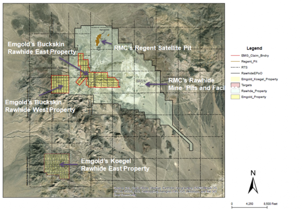
Buckskin Rawhide East Property
(Location Adjacent to Rawhide Mine and Other Emgold Properties)
Note Emgold owns also owns the Buckskin Rawhide West and Koegel Rawhide Properties in the vicinity of Rawhide Mine.
GEOLOGY & MINERALIZATION
The Buckskin Rawhide East Property is a volcanic-hosted, structurally controlled, epithermal gold-silver target situated in the Walker Lane gold belt of western Nevada. The Walker Lane is a regional shear zone and known gold trend that has hosted large and small historic and recent gold-silver mines in western Nevada, including mines of the Comstock Lode, Tonopah District and Rawhide District. From 1981 through 2009, mines located in Mineral County that were situated in the Walker Lane gold trend have produced 2,800,448 ounces of gold and 56,112,442 ounces of silver (Muntean, 2010).
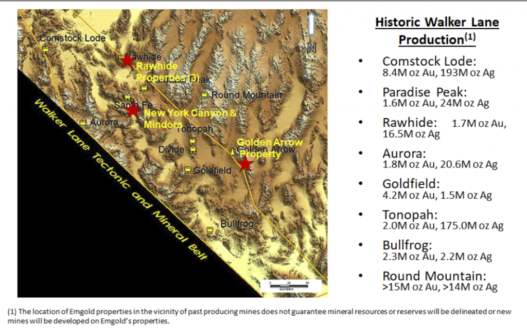
Emgold Properties and Historic
Walker Lane Gold Production
Property geology and mineralization is similar to the adjacent Rawhide Mine. Mineralization is associated with structures from the Walker Lane and the Basin and Range along with lithologic units and structures of the Rawhide volcanic center.
Four main mineralized exploration targets have been identified from historical work:
- Toiyabe
- Chicago Mountain
- Black Eagle
- North Buckskin Mountain
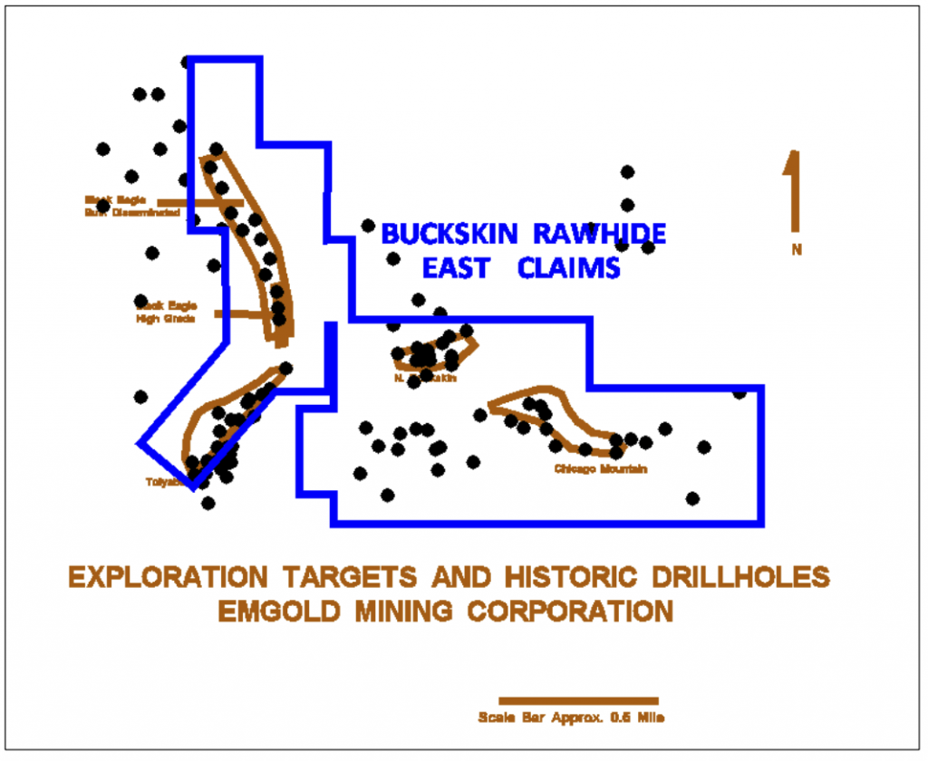
Buckskin Rawhide East Property
Exploration Targets
EXPLORATION
Gold was originally discovered on the Buckskin Rawhide claims in the year 1906. A gold rush in the area led to a number of mining claims being staked, ultimately forming the Regent Mining District (now known as the Rawhide Mining District). The gold rush led to the formation of the town of Rawhide, which grew to a population of 7,000 by 1908, but dropped to 500 by the year 1910. By the 1940’s, the town was essentially abandoned.
The Rawhide District was active with mining from 1908-1920, during which time 46,218 fine ounces of gold and 685,901 fine ounces of silver were produced from the historic mines. During this period, historic mining activity occurred on the Property and a number of shafts, adits, and stopes were excavated. No production records appear to exist from these operations. From 1921 through 1935, only 2,815 fine ounces of gold and 51,463 fine ounces of silver were produced from the Rawhide Mining District (Vanderburg, 1937).
Modern exploration at in the Rawhide area, including the Buckskin Rawhide East Property, appears to have begun in 1982. Exploration activities on the Property consisted of geologic and alteration mapping, surface rock chip geochemical sampling, and reverse circulation drilling, most of which was done by Kennecott Exploration Company. At that time, Kennecott was exploring the entire Rawhide District, eventually discovering and developing the Rawhide Mine. Other companies also conducted reconnaissance exploration in the area.
Kennecott drilled 84 RC drill holes totaling 39,820 feet on Buckskin Rawhide East in the 1990’s. This drilling was done before the implementation of NI 43-101 and CIM Standards for Disclosure. It provides a useful guide for current exploration by the Company’s geologists.
Work done by Kennecott focused on exploration for bulk disseminated mineralized targets with potential to generate satellite resources that might be ultimately be processed at the Rawhide Mine facilities, subject to exploration success, permitting, and other factors. The four targets identified are Toiyabe, Chicago Mountain, Black Eagle, and North Buckskin Mountain. All of these targets show promise for discovery of resources but additional exploration will be required to both define the size and grade of targets as well as to generate exploration data that meets current standards of disclosure.
Emergent's exploration, after optioning/acquiring the Property, focused on two main targets, the Black Eagle Target (including the Black Eagle High Grade Vein Zone) and the Chicago Mountain Bulk Disseminated Target. In 2011, Emgold sampled both these targets.
Surface sampling by Emgold in the Chicago Mountain area was designed to develop an understanding of the mineralized structures in that area. Twenty-five rock chip-channel samples, ranging from 6-12 inches in length, were taken from outcrops of bedrock and structures. Five samples were also taken from historic mine dumps. Six of these samples were in the mineralized area. Emgold compared these results to 105 historic samples taken by others, as shown in Table 1. Note these historic samples were taken prior to the implementation of NI 43-101 and CIM standards of disclosure.
Table 1
Gold Assays from Rock Chip Sampling
Chicago Mountain Target
Buckskin Rawhide East Property, NV
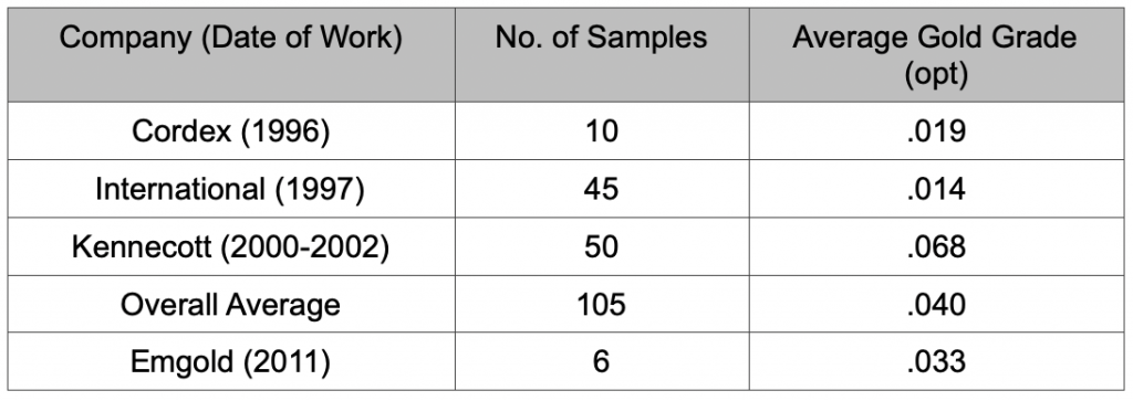
From this sampling, Emgold identified an exploration target of approximately 4,000 feet by 400 feet
(see October 4, 2011 press release for details) as a drill target.
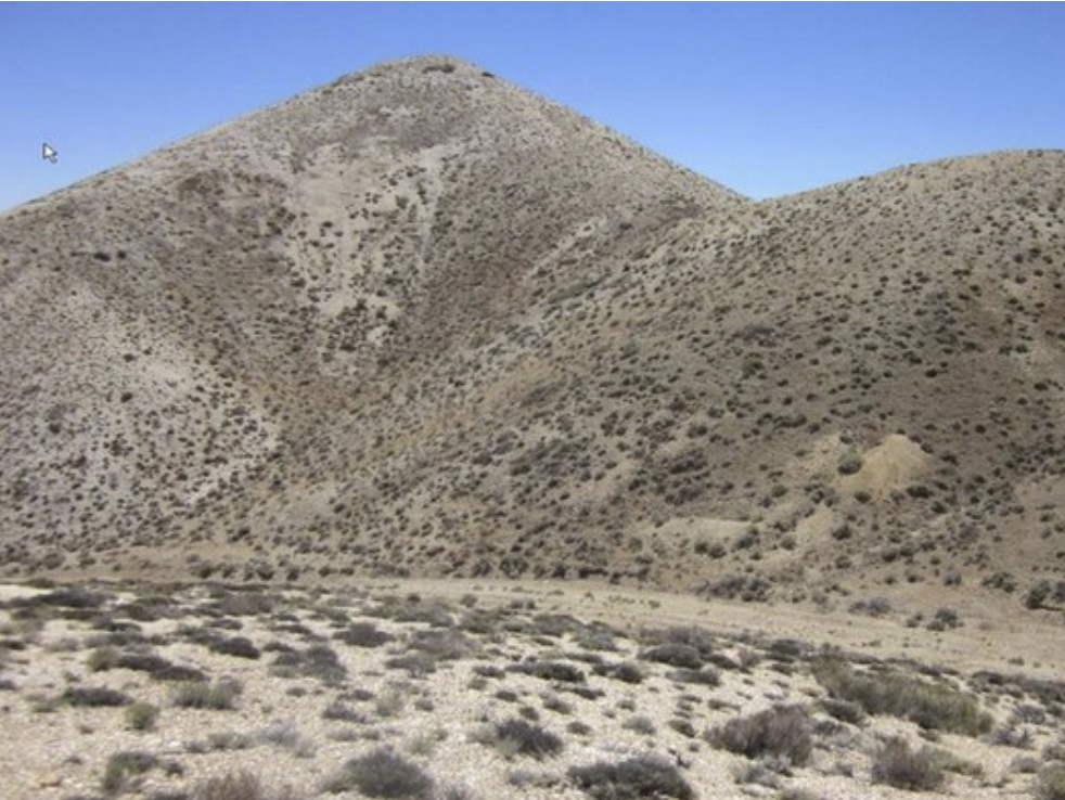
Buckskin Rawhide East Property
Chicago Mountain Target Looking East
Emergent's work also focused on the Black Eagle Fault, a north-trending, steep dipping structure typically ten feet in width situated on the west side of Emgold’s claim block. The surrounding volcanic bedrock consists of latite porphyry flows and a hydrothermal breccia dike. These dikes were mapped by Kennecott elsewhere on the Property and were termed vent breccia. The vent breccias appear to be associated with mineralized structures. The gold-silver mineralization is related to the fault and occurs over a measured strike length of 1,100 feet (and open to extension). Hydrothermal alteration is prominent along the structure.
Within this fault structure, Emgold identified the Black Eagle High Grade Zone, which consists of fault gouge, quartz veins, and silicified wall rocks with associated fracture coatings of iron-manganese oxides. This target is currently 360 feet in strike length, open to extension, and contains high grade gold. It is interpreted to be a fault segment of permeable gouge that was injected with mineralized hydrothermal fluids.
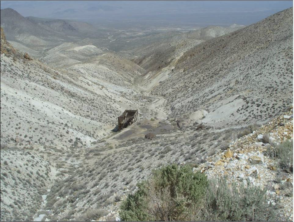
Buckskin Rawhide East Property
Black Eagle Fault Looking North
Rock chip samples in the Black Eagle High Grade Zone are shown in Table 2 below.
Table 2
Gold and Silver Assays from Rock Chip Sampling
Black Eagle High Grade Vein Target
Buckskin Rawhide East Property, NV
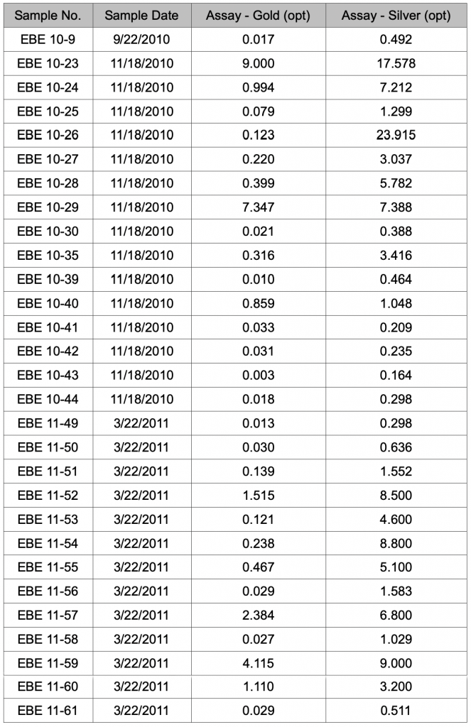
All samples are chip-channel samples taken over 12 inch widths, except 10-9 which is taken over 24 inches. These are not true widths across the vein. See Emergent's January 12, 2011 and April 19, 2011 press released for additional detail.
To date, Emgold has taken 106 surface rock chip samples along with seven grab samples of historic mine dumps and bedrock along the potential strike of the Black Eagle vein structure. These results indicate:
- The potential for the presence of low grade bulk disseminated mineralization in the vicinity of the high grade zone (east and west of high grade zone, which carries low grade gold and silver mineralization). Eighteen samples had grades between 0.010 and 0.039 ounce per ton gold.
- The potential for additional higher grade mineralization on the Black Eagle Fault, as suggested by EBE 11-64, to the north of the high grade zone, with a grade of 0.136 ounce per ton gold and 1.109 ounce per ton silver.
- The potential for mineralized historic waste dumps of relatively small tonnage (see EBE-D, EBE-ST-D, EBE-ST-L, Shaft West, and Shaft North). Three of these five samples had grades greater than 0.100 ounce per ton gold.
- The potential for mineralized splay faults and fractures, as seen in the south end of Black Eagle Fault.
A total of 57 samples collected to date had gold grades that were non-detectable or below 0.010 ounce per ton gold, indicating that mineralization was not present in all of the wall rocks or structures sampled.
Emergent's quality assurance program and quality control measures for exploration at Buckskin Rawhide were described in the press release dated October 4, 2011 and pertain to all surface geochemical samples taken on the property. Quality control measures included representative sampling, proper numbering, and accurately locating samples in the field both visually on maps and also with a GPS instrument. Samples were transported by the geological staff from the field to Emergent's office-warehouse facility to assure secure storage, and were then packaged for shipment to the assay laboratory. The Company also incorporated its own samples as test blanks and assaying standards for analysis. Samples were transported by Emgold employees or shipped via commercial carriers directly to the assay laboratory for analysis.
Emergent's Qualified Person Mr. Robert Pease, Chief Geologist of the Company, visited the assay laboratories to review the general sample handling and preparation measures, to make sure they were adequate. The assay laboratory catalogued all samples, maintained complete chain of custody throughout the analytical process, and electronically mailed the chain of custody forms to Emgold for review prior to initiating sample preparation. All sample preparation was done at the laboratory by their staff. As part of their quality assurance, the laboratory incorporated assaying standards, test blanks, and duplicate analyses of samples, and included those results in final reports. The final signed reports complete the chain of custody process. Thus far, no factors have been encountered in sampling programs conducted by Emgold on the Buckskin Rawhide East Property that would materially affect the accuracy or reliability of Emergent's sample data or cause loss of confidence in the laboratory. American Assay Laboratories, Inc. of Sparks, Nevada, an independent and adequately certified laboratory, conducted the laboratory analyses of Emergent's samples. Samples taken by Emgold were analyzed using standard fire assaying and ICP methods.
In 2013, RMC drilled 22 RC drill holes totaling 7,100 ft. in the Chicago Mountain Target. Drilling confirmed mineralization of similar nature and grade to historic drilling in this target that was conducted by Kennecott in the year 2000 (15 holes with 10 holes in the mineralized zone). Additional drilling is needed prior to any mineral resources or mining reserves being defined in this area.
Historic work was also completed by Kennecott on the Toiyabe and North Buckskin Mountain areas, including drilling. No significant work has been done in these areas since 2000, but historic drilling shows potential for discovery of mineral resources, subject to additional drilling. RMC has plans to drill all four historic targets, subject to financing, with the goal of developing mineral resources that can be potentially processed at the nearby Rawhide Mine facilities. However, currently no mineral resources or reserves have been defined on the Buckskin Rawhide East Property and there can be no guarantee that development of mineral resources or mining reserves will be successful.
TECHNICAL REPORT
No Technical Report has yet been completed for the Property.
QUALIFICATIONS
Mr. Robert Pease, CPG, acting as the Qualified Person for Emgold, has reviewed and approved the information on this webpage.
REFERENCES
Muntean, J. L., 2010, Major Precious-Metal Deposits, in the Nevada Mineral Industry 2009: Nevada Bureau of Mines and Geology Special Publication MI-2009.
Nevada Bureau of Mines and Geology Special Publications (multiple years used to obtain Rawhide Mine production data.
Vanderburg, W. O., 1937, Reconnaissance of Mining Districts in Mineral County, Nev.: Dept. of the Interior United States Bureau of Mines Information Circular 6941.
DISCLAIMER
Readers are cautioned to review the Disclaimer Page on this website for qualifications that may be applicable to the information contained on this Property Page, including forward looking statements, definitions of mineral resources and reserves, etc. Readers are also cautions to review Emergent's financial statements and management’s discussion and analysis available on this website or at www.sedar.com for additional information.
PROPERTY OVERVIEW
|
LOCATION |
40 mi southeast of Fallon, NV |
|
TYPE OF PROJECT |
Early stage exploration |
|
NUMBER OF CLAIMS |
48 unpatented claims |
|
PROPETY SIZE |
̴ 960 ac. |
|
OWNERSHIP |
100% owned by Emgold |
|
PROPERTY STATUS |
Leased to Rawhide Mining LLC (“RMC”) |
|
UNDERLYING ROYALTIES |
None |
|
EXPLORATION COMPLETED |
|
|
KEY EXPLORATION TARGETS |
Toiyabe, Chicago Mountain/Gulch, Black Eagle, and North Buckskin Mountain |
|
NI 43-101 TECHNICAL REPORT |
None completed to date |
|
MINERAL RESOURCES |
None defined to date |
|
EXPLORATION HIGHLIGHTS |
|
INTRODUCTION
The Buckskin-Rawhide East Property (“Buckskin Rawhide East” or the “Property”) is an early stage gold and silver exploration property located in the Walker Lane Gold Belt in the Rawhide Mining District, Mineral County, Nevada. Gold was originally discovered at Rawhide, NV in 1906. In the 1980’s, Kennecott Exploration Company consolidated a land package that included the property that Emgold now calls Buckskin Rawhide East. In 1988, Kennecott Minerals Company developed the Rawhide Mine (aka Denton Rawhide Mine).
Town of Rawhide, NV, Circa 1915
Kennecott suspended mining operations at the mine in May 2003 due to low gold prices, but the mine continued to produce gold from existing heap leach pads. From 1990 through 2010, while operated by Kennecott, the Rawhide Mine produced 1.5 million ounces of gold and 12.4 million ounces of silver (Nevada Bureau of Mines). After shutting down operations, Kennecott reduced their land holdings, ultimately resulting in the formation of two adjacent properties – Buckskin Rawhide East that subsequently became owned by Emgold and the Regent Property that subsequently became owned by Pilot Gold Corporation (now called Liberty Gold Corporation (TSX: LDG)).
In 2010, the Rawhide Mine was acquired by RMC, a private company. They continued to produce gold and silver from the heap leach pads. In 2012, with rising gold prices RMC recommenced mining activities at Rawhide Mine. In 2013, RMC leased Buckskin Rawhide East from Emgold and acquired the Regent Property from Pilot Gold. This re-consolidated the land package formerly controlled by Kennecott. As a result, the Buckskin Rawhide East mineral claims have become “inlying” claims to the current Rawhide Mine Property.
In 2019, RMC completed a Plan of Operations and Environmental Assessment to expand its operations and mine from the Regent deposit located on the Regent Property. The Buckskin Rawhide East Property was also included in the Environmental Assessment, which allows exploration activities to occur on the Property subject to completion of certain site specific environmental studies. In 2019, RMC commenced production from the Regent Pit.
As of 2018, the latest available public data, Rawhide Mine has produced 1.7 million ounces of gold and 16.5 million ounces of silver (Nevada Bureau of Mines). In 2019, mining began from the recently permitted Regent deposit. RMC plans to ultimately explore for, and if successful, develop additional mineral resources on the Regent and Buckskin Rawhide East Properties, with the goal of extending the life of Rawhide Mine.
RMC has the right to acquire ownership of Buckskin Rawhide East by bringing it into commercial production. Upon reaching commercial production, Emergent's interest will convert into a royalty interest whereby Emgold will receive payments of US$15 per ounce of gold produced when the price of gold is above US$1,200 per ounce and up to US$1,799 per ounce of gold, with payments increasing to US$20 per ounce of gold produced when the gold price rises to or above US$1,800 per ounce of gold.
Note that there are currently no mineral resources or reserves delineated on the Property that meet NI 43-101 or CIM standards of disclosure. The proximity of the Property to adjacent operating mines does not guarantee exploration success, mineral resources or reserves will be defined, commercial production will be achieved, or royalty payments will be generated on the Property.
LOCATION & OWNERSHIP
The Buckskin-Rawhide East Property (“Buckskin Rawhide East” or the “Property”) is an early stage gold and silver exploration property located in the Walker Lane Gold Belt in the Rawhide Mining District, Mineral County, Nevada. It is located approximately 40 miles southeast of Fallon, NV.
Buckskin Rawhide East Property
Location Map
Emgold optioned Buckskin Rawhide East in 2009. At that time, the Property consisted of 46 unpatented mineral claims which were leased through an agreement with Nevada Sunrise Gold Corporation (TSXV: NEV) (“Nevada Sunrise”). Nevada Sunrise had a 75 percent interest in 40 of the claims and a 100 percent interest in 6 of the claims. Nevada Sunrise also controlled the remaining 25 percent interest in the 40 claims through an underlying agreement with the Estate of Maurice and Lorraine Castagne. Emgold subsequently staked 6 additional claims, increasing the property size to 52 claims.
In 2013, Emgold acquired Nevada Sunrise’s interest in the 46 claims and subsequently acquired the remaining 25 percent interest in the 40 claims from the Estate of Maurice and Lorraine Castagne. Upon completion of the acquisition, Emgold held a 100 percent interest in the 52 unpatented mineral claims with no underlying royalty interests.
In 2012 and 2013, RMC completed a series of private placement into Emgold totalling US$1.0 million. Part of the proceeds from this private placement was used to acquire the Property from Nevada Sunrise and the Estate of Maurice and Lorraine Castagne. Upon completion of the series of private placements and acquisition of 100 percent Property by Emgold from the underlying owners, RMC leased the Property from Emgold, based on the following terms:
- A Lease Term is 20 years.
- Advance royalty payments will be $10,000 per year, paid by RMC to Emgold, with the first payment due at signing and subsequent payments due on the anniversary of the Lease Agreement (effective date June 1, 2013).
- During the Lease Term, RMC will make all underlying claim fees to keep the claims in good standing.
- RMC will conduct a minimum of US$250,000 in exploration activities by the end of Year 1.
- RMC will conduct an additional minimum of US$250,000 in exploration activities by the end of Year 3, for a total of US$500,000 in exploration activities by the end of Year 3.
- RMC will have the option of earning a 100% interest in the Property by bringing it into commercial production.
- Upon bringing the property into commercial production, RMC will make “Bonus Payments” to Emgold. Bonus Payments will be US$15 per ounce of gold mined from the Buckskin Rawhide Property when the price of gold ranges between US$1,200 per ounce and US$1,799 per ounce. If the price of gold exceeds US$1,800 per ounce, the Bonus Payment will increase to US$20 per ounce
RMC completed its minimum exploration expenditures in Year 1 (2013). It did not complete all its requirements required by Year 3 and made cash payments in lieu of exploration work to Emgold (see June 1, 2016 press release). The Property is in good standing and RMC makes annual advance royalty payments to Emgold of US$10,000 per year.
In 2018, RMC resurveyed in the Buckskin Rawhide East claims to ensure their validity and to eliminate overlap between various claims. This resulted in a reduction of claims to 48 claims, with an estimated area of approximately 960 acres.
Buckskin Rawhide East Property
(Location Adjacent to Rawhide Mine and Other Emgold Properties)
Note Emgold owns also owns the Buckskin Rawhide West and Koegel Rawhide Properties in the vicinity of Rawhide Mine.
GEOLOGY & MINERALIZATION
The Buckskin Rawhide East Property is a volcanic-hosted, structurally controlled, epithermal gold-silver target situated in the Walker Lane gold belt of western Nevada. The Walker Lane is a regional shear zone and known gold trend that has hosted large and small historic and recent gold-silver mines in western Nevada, including mines of the Comstock Lode, Tonopah District and Rawhide District. From 1981 through 2009, mines located in Mineral County that were situated in the Walker Lane gold trend have produced 2,800,448 ounces of gold and 56,112,442 ounces of silver (Muntean, 2010).
Emgold Properties and Historic
Walker Lane Gold Production
Property geology and mineralization is similar to the adjacent Rawhide Mine. Mineralization is associated with structures from the Walker Lane and the Basin and Range along with lithologic units and structures of the Rawhide volcanic center.
Four main mineralized exploration targets have been identified from historical work:
- Toiyabe
- Chicago Mountain
- Black Eagle
- North Buckskin Mountain
Buckskin Rawhide East Property
Exploration Targets
EXPLORATION
Gold was originally discovered on the Buckskin Rawhide claims in the year 1906. A gold rush in the area led to a number of mining claims being staked, ultimately forming the Regent Mining District (now known as the Rawhide Mining District). The gold rush led to the formation of the town of Rawhide, which grew to a population of 7,000 by 1908, but dropped to 500 by the year 1910. By the 1940’s, the town was essentially abandoned.
The Rawhide District was active with mining from 1908-1920, during which time 46,218 fine ounces of gold and 685,901 fine ounces of silver were produced from the historic mines. During this period, historic mining activity occurred on the Property and a number of shafts, adits, and stopes were excavated. No production records appear to exist from these operations. From 1921 through 1935, only 2,815 fine ounces of gold and 51,463 fine ounces of silver were produced from the Rawhide Mining District (Vanderburg, 1937).
Modern exploration at in the Rawhide area, including the Buckskin Rawhide East Property, appears to have begun in 1982. Exploration activities on the Property consisted of geologic and alteration mapping, surface rock chip geochemical sampling, and reverse circulation drilling, most of which was done by Kennecott Exploration Company. At that time, Kennecott was exploring the entire Rawhide District, eventually discovering and developing the Rawhide Mine. Other companies also conducted reconnaissance exploration in the area.
Kennecott drilled 84 RC drill holes totaling 39,820 feet on Buckskin Rawhide East in the 1990’s. This drilling was done before the implementation of NI 43-101 and CIM Standards for Disclosure. It provides a useful guide for current exploration by the Company’s geologists.
Work done by Kennecott focused on exploration for bulk disseminated mineralized targets with potential to generate satellite resources that might be ultimately be processed at the Rawhide Mine facilities, subject to exploration success, permitting, and other factors. The four targets identified are Toiyabe, Chicago Mountain, Black Eagle, and North Buckskin Mountain. All of these targets show promise for discovery of resources but additional exploration will be required to both define the size and grade of targets as well as to generate exploration data that meets current standards of disclosure.
Emergent's exploration, after optioning/acquiring the Property, focused on two main targets, the Black Eagle Target (including the Black Eagle High Grade Vein Zone) and the Chicago Mountain Bulk Disseminated Target. In 2011, Emgold sampled both these targets.
Surface sampling by Emgold in the Chicago Mountain area was designed to develop an understanding of the mineralized structures in that area. Twenty-five rock chip-channel samples, ranging from 6-12 inches in length, were taken from outcrops of bedrock and structures. Five samples were also taken from historic mine dumps. Six of these samples were in the mineralized area. Emgold compared these results to 105 historic samples taken by others, as shown in Table 1. Note these historic samples were taken prior to the implementation of NI 43-101 and CIM standards of disclosure.
Table 1
Gold Assays from Rock Chip Sampling
Chicago Mountain Target
Buckskin Rawhide East Property, NV
From this sampling, Emgold identified an exploration target of approximately 4,000 feet by 400 feet (see October 4, 2011 press release for details) as a drill target.
Buckskin Rawhide East Property
Chicago Mountain Target Looking East
Emergent's work also focused on the Black Eagle Fault, a north-trending, steep dipping structure typically ten feet in width situated on the west side of Emgold’s claim block. The surrounding volcanic bedrock consists of latite porphyry flows and a hydrothermal breccia dike. These dikes were mapped by Kennecott elsewhere on the Property and were termed vent breccia. The vent breccias appear to be associated with mineralized structures. The gold-silver mineralization is related to the fault and occurs over a measured strike length of 1,100 feet (and open to extension). Hydrothermal alteration is prominent along the structure.
Within this fault structure, Emgold identified the Black Eagle High Grade Zone, which consists of fault gouge, quartz veins, and silicified wall rocks with associated fracture coatings of iron-manganese oxides. This target is currently 360 feet in strike length, open to extension, and contains high grade gold. It is interpreted to be a fault segment of permeable gouge that was injected with mineralized hydrothermal fluids.
Buckskin Rawhide East Property
Black Eagle Fault Looking North
Rock chip samples in the Black Eagle High Grade Zone are shown in Table 2 below.
Table 2
Gold and Silver Assays from Rock Chip Sampling
Black Eagle High Grade Vein Target
Buckskin Rawhide East Property, NV
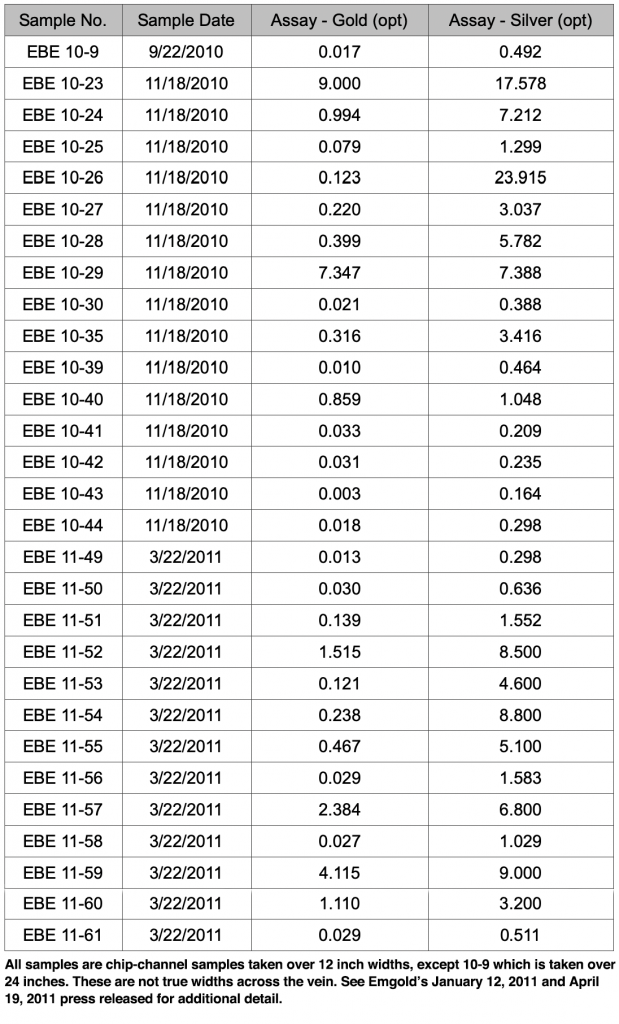
To date, Emgold has taken 106 surface rock chip samples along with seven grab samples of historic mine dumps and bedrock along the potential strike of the Black Eagle vein structure. These results indicate:
- The potential for the presence of low grade bulk disseminated mineralization in the vicinity of the high grade zone (east and west of high grade zone, which carries low grade gold and silver mineralization). Eighteen samples had grades between 0.010 and 0.039 ounce per ton gold.
- The potential for additional higher grade mineralization on the Black Eagle Fault, as suggested by EBE 11-64, to the north of the high grade zone, with a grade of 0.136 ounce per ton gold and 1.109 ounce per ton silver.
- The potential for mineralized historic waste dumps of relatively small tonnage (see EBE-D, EBE-ST-D, EBE-ST-L, Shaft West, and Shaft North). Three of these five samples had grades greater than 0.100 ounce per ton gold.
- The potential for mineralized splay faults and fractures, as seen in the south end of Black Eagle Fault.
A total of 57 samples collected to date had gold grades that were non-detectable or below 0.010 ounce per ton gold, indicating that mineralization was not present in all of the wall rocks or structures sampled.
Emergent's quality assurance program and quality control measures for exploration at Buckskin Rawhide were described in the press release dated October 4, 2011 and pertain to all surface geochemical samples taken on the property. Quality control measures included representative sampling, proper numbering, and accurately locating samples in the field both visually on maps and also with a GPS instrument. Samples were transported by the geological staff from the field to Emergent's office-warehouse facility to assure secure storage, and were then packaged for shipment to the assay laboratory. The Company also incorporated its own samples as test blanks and assaying standards for analysis. Samples were transported by Emgold employees or shipped via commercial carriers directly to the assay laboratory for analysis.
Emergent's Qualified Person Mr. Robert Pease, Chief Geologist of the Company, visited the assay laboratories to review the general sample handling and preparation measures, to make sure they were adequate. The assay laboratory catalogued all samples, maintained complete chain of custody throughout the analytical process, and electronically mailed the chain of custody forms to Emgold for review prior to initiating sample preparation. All sample preparation was done at the laboratory by their staff. As part of their quality assurance, the laboratory incorporated assaying standards, test blanks, and duplicate analyses of samples, and included those results in final reports. The final signed reports complete the chain of custody process. Thus far, no factors have been encountered in sampling programs conducted by Emgold on the Buckskin Rawhide East Property that would materially affect the accuracy or reliability of Emergent's sample data or cause loss of confidence in the laboratory. American Assay Laboratories, Inc. of Sparks, Nevada, an independent and adequately certified laboratory, conducted the laboratory analyses of Emergent's samples. Samples taken by Emgold were analyzed using standard fire assaying and ICP methods.
In 2013, RMC drilled 22 RC drill holes totaling 7,100 ft. in the Chicago Mountain Target. Drilling confirmed mineralization of similar nature and grade to historic drilling in this target that was conducted by Kennecott in the year 2000 (15 holes with 10 holes in the mineralized zone). Additional drilling is needed prior to any mineral resources or mining reserves being defined in this area.
Historic work was also completed by Kennecott on the Toiyabe and North Buckskin Mountain areas, including drilling. No significant work has been done in these areas since 2000, but historic drilling shows potential for discovery of mineral resources, subject to additional drilling. RMC has plans to drill all four historic targets, subject to financing, with the goal of developing mineral resources that can be potentially processed at the nearby Rawhide Mine facilities. However, currently no mineral resources or reserves have been defined on the Buckskin Rawhide East Property and there can be no guarantee that development of mineral resources or mining reserves will be successful.
TECHNICAL REPORT
No Technical Report has yet been completed for the Property.
QUALIFICATIONS
Mr. Robert Pease, CPG, acting as the Qualified Person for Emgold, has reviewed and approved the information on this webpage.
REFERENCES
Muntean, J. L., 2010, Major Precious-Metal Deposits, in the Nevada Mineral Industry 2009: Nevada Bureau of Mines and Geology Special Publication MI-2009.
Nevada Bureau of Mines and Geology Special Publications (multiple years used to obtain Rawhide Mine production data.
Vanderburg, W. O., 1937, Reconnaissance of Mining Districts in Mineral County, Nev.: Dept. of the Interior United States Bureau of Mines Information Circular 6941.
DISCLAIMER
Readers are cautioned to review the Disclaimer Page on this website for qualifications that may be applicable to the information contained on this Property Page, including forward looking statements, definitions of mineral resources and reserves, etc. Readers are also cautions to review Emergent's financial statements and management’s discussion and analysis available on this website or at www.sedar.com for additional information.