PROPERTY OVERVIEW
| LOCATION | 80 km south of La Sarre or 105 km west-southwest of Matagami, Quebec |
| TYPE OF PROJECT | Early stage exploration |
| NUMBER OF CLAIMS | 204 |
| PROPERTY SIZE | 11,400 ha |
| OWNERSHIP | 100% Emgold |
| PROPERTY STATUS | Available for option, joint venture, or sale |
| UNDERLYING ROYALTIES | 1.5% NSR of which 0.5% can be purchased by Emgold for $500,000 |
| EXPLORATION COMPLETED |
|
| KEY EXPLORATION TARGETS |
|
| NI 43-101 TECHNICAL REPORTS |
NI 43-101 Technical Report, Casa South Property, NTS 32E06/32E11, Northwestern Quebec, Demers and Theberge, March 8, 2019 |
| MINERAL RESOURCES | None yet defined |
| EXPLORATION HIGHLIGHTS |
|
INTRODUCTION
On December 15, 2018, Emgold announced it had completed an assignment agreement with a third party, a privately held company, granting Emgold its rights, held through a binding Letter of Intent (“LOI”) with Greg Exploration Inc. and Affiliates (“Greg”) to acquire up to a 91% interest in the Casa South Property, Quebec (“Casa South” or the “Property”). On March 19, 2019, the Company announced it had obtained Toronto Venture Exchange approval for the transaction. On June 13, 2019, Emgold announced it has amended its Agreement with the Greg to acquire a 100% interest in the Property, with the acquisition being completed on July 17, 2019.
The Property comprises 204 active mining titles covering a total of about 11,400 hectares (110 square kilometers). It extends immediately south of Hecla Mining Corporation’s (NYSE:HL) Casa Berardi Mine operation and extends laterally for 20 kilometers covering different sub-parallel structures corresponding to a distinct geophysical signatures and hosting elevated gold values in soil anomalies. The Casa Berardi Mine has produced approximately 2.5 million recovered gold ounces since commencing production in 1988 to the end of 2018 at an average grade of 6.58 g/t gold (source: Technical Report on Casa Berardi Mine, Hecla, 2018).
The Property is also located north and adjacent to IAMGOLD Corporation’s (NYSE:IAG) Gemini Turgeon Property (Turgeon claims are 50% owned by IAMGOLD and 50% owned by Yorbeau Resources Corporation (TSX:YRB); Turgeon claims are 37.5% owned by IAMGOLD, 37.5% owned by Yorbeau, and 25% owned by Vale S.A. (NYSE:VALE)). This property has historically been explored for auriferous massive sulfides with four zones discovered to date.
Note that the presence of mineral resources and reserves found on the Casa Berardi Mine Property do not guarantee discovery or delineation of mineral resources and reserves on the Casa South Property.
LOCATION & OWNERSHIP
The Property is located approximately 80 kilometers north of the town of La Sarre, Quebec or 105 kilometers west south-west of Matagami in the Casa Berardi Township, James Bay Municipality. It is located south of the Casa Berardi Mine, owned and operated by Hecla Mining Corporation. It is accessible going north from La Sarre via Casa Berardi Mine’s all season gravel road. The Property consists of 204 active mining titles covering a total of about 11,400 hectares (110 sq. km.). The claims are in one contiguous block.
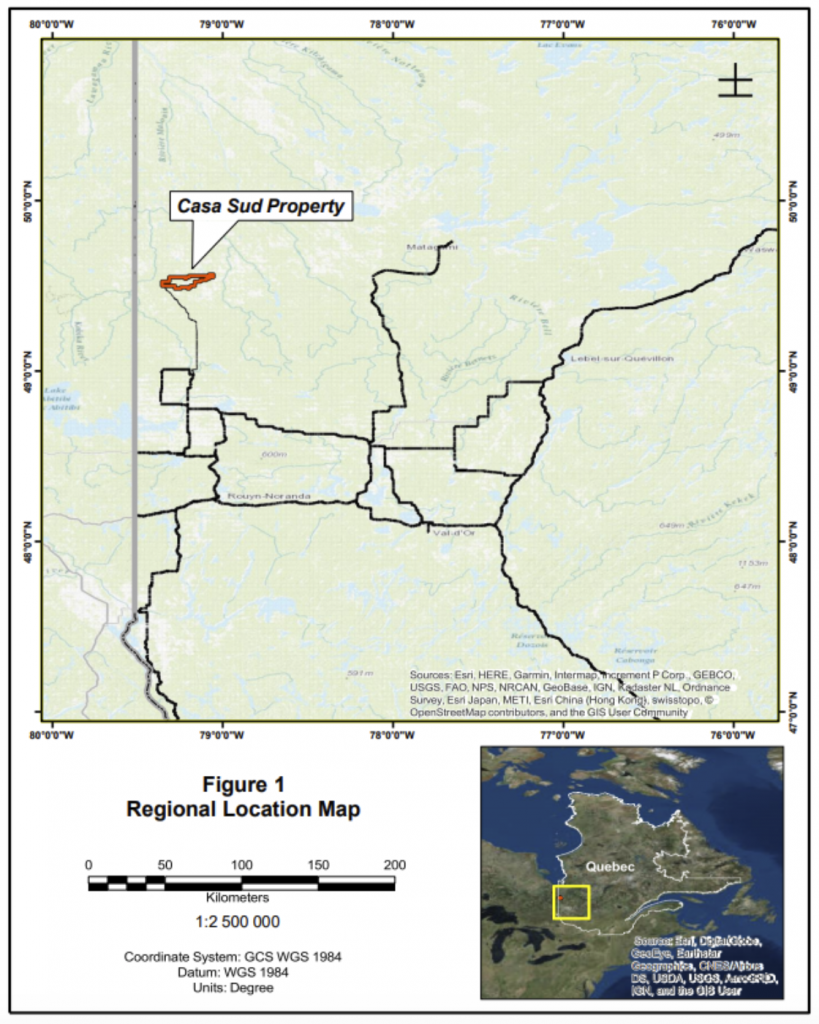
Casa South Property
Location Map
Emergent's assumption of the rights held through a LOI with a third party allowed Emgold the option to acquire up to a 91% interest in the Property from Greg. At that time, the Property consisted of 180 claims totaling 10,061 ha. On March 19, 2019, Emgold announced that it has obtained approval from the Toronto Venture Exchange for the transaction. On June 13, 2019, Emgold announced that it had completed amendment with Greg to the Definitive Agreement allowing it the option to acquire a 100% interest in the Property. The Company also it announced it was exercising that option.
A one and a half percent (1.5%) Net Smelter Royalty (“NSR”) was granted to the Vendors on the Property, being agreed that half a percent (0.5%) of said NSR can be repurchased by Emgold for an amount of C$500,000.
On July 17, 2019, Emgold announced it had completed the transaction and acquired a 100% interest in Casa South. On February 5, 2020, Emgold announced that it had expanded its claim package by adding 24 mineral claims totaling approximately 1,320 ha. Total property size was now 204 claims and 11,400 ha.
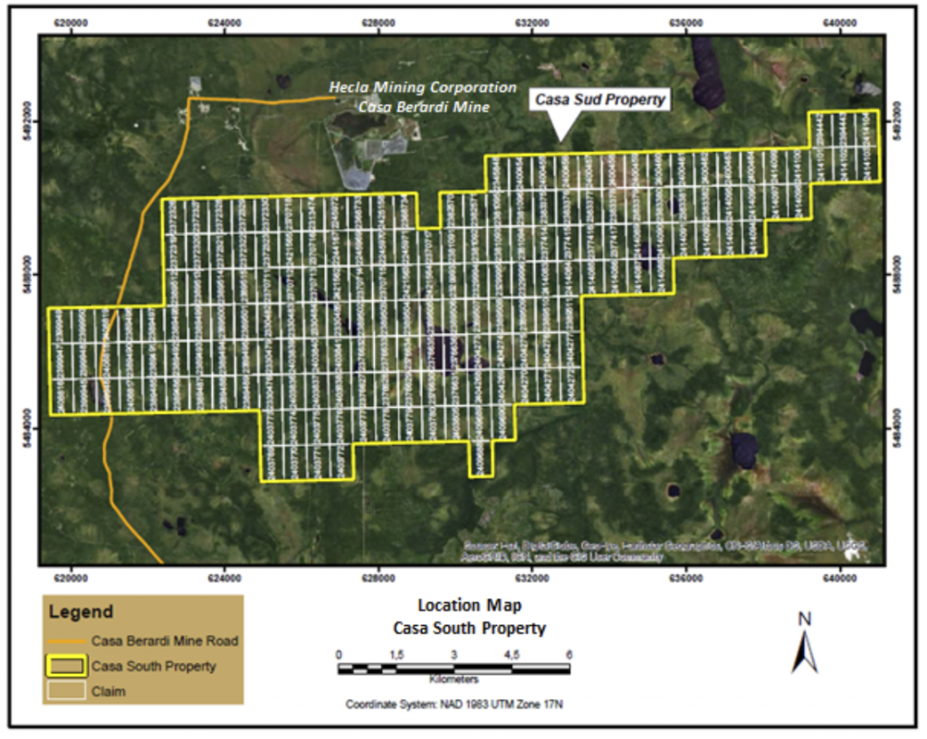
Casa South Property
Claim Map
GEOLOGY & MINERALIZATION
The property is located inside the northwestern segment of the Abitibi Greenstone Belt and is part of the North Volcanic Zone. The Casa Berardi area was previously included in the Harricana-Turgeon Through by fundamental regional geology studies produced by the MERN following the discovery of the Casa Berardi deposit (Lacroix S., et al., 1990).
The Abitibi Belt is the most important Greenstone Belt in terms of size and metal content of the Superior Province, which is the Archean core of the Canadian Shield. The Belt is transected along the western side by the Kapuskasing uplift and on the eastern and southern side, by the Grenville Front, both extending along 300 km contact line and representing Proterozoic limits. To the north, volcano-sedimentary sequences are interpenetrated with the Opatica Sub-Province.
The Property encompasses a lithologic context similar to the Cass Berardi deposit. Its exploration history followed the same stages of evolution over a period of time from the 1960 to 1990 where exploration focused on sulfide rich polymetallic deposits similar to the Kidd Creek, Selbaie, or Mattagami deposits discovered in the northern part of the Abitibi belt. Exploration work on the claims was done by companies such as Newmont, Noranda, and Cambior, among others.
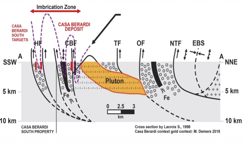
Casa South Property
Deposit Model
Casa South Property
Geology Map
Three main exploration targets have been identified on the Casa South Property. One is a major gold bearing structure south of Casa Berardi Mine called the Kama Trend. Another is the Central Till Anomaly, and the third is the Northwest Magnetic Anomaly defined by geophysics.
Casa South Property
Exploration Targets
EXPLORATION
Exploration results in Quebec are preserved through Assessment reports filed with by the Ministry of Energy, Mines, and Natural Resources (MERN). This exploration history is a summary of work documented in those reports. Note that the work applies to claims that were in staked at that time the work was done and a report may apply only to a portion (a subset) of the current claims that make up the Property.
Exploration Prior to 1970
In 1919, T.L. Tanton mapped the Harricana-Turgeon basin at 4 miles = 1 inch. Tanton’s study area included part of the Casa South Property. After the discoveries of many deposits, mining companies and prospectors evinced considerable interest in the Abitibi and Northern Greenstone belts. In the Property area, interest (late 1950) centered on a broad belt of volcanic-sedimentary Precambrian rocks.
The first work listed on the property in the MRNF files (SIGEOM) belongs to Moneta Porcupine Mines (GM 15689 — GM 10847). They drilled seven holes totaling 2,318 feet in 1959 (5 on the Casa South Property). A preliminary airborne magnetic and electromagnetic survey followed by ground geophysical work indicated the anomalies to be tested. Traces of gold were noted in the assays from two holes.
In 1961-1964 the Province of Quebec conducted geological studies that encompassed part of the Property (RG 116— RP 475).
A geophysical survey was made by United States Smelting, Refining and Mining Co in 1968 (GM 23389) to locate and evaluate conductors located in a previous airborne electromagnetic survey. In the summer of the same year a geochemical sampling program and geological information were carried out (GM 23388). Another EM survey was done in 1969 (GM 24712) and the best anomalies were drilled in 1969 with 3 holes totaling 1,372 feet (GM 24713). Around the same year (1968), SOQUEM, conducts MAG and EM surveys in the western part of the property to check a series of INPUT anomalies (GM 22426 — GM 22409).
Exploration after 1970 – Noranda Exploration
In 1973, Noranda Exploration flew an airborne EM survey on the east side of the property. Two long formational trends dominate the survey area. The northerly one is considered to be an iron formation and the other one to be a volcanic-sediment contact zone previously checked. Some isolated zones were considered for future targets (GM 48987).
In 1974, Noranda did some ground MAG/EM surveys, on a property around Janelle Lake (GM 30470 — GM 30056) and around Casa Lake (GM 29740), and in 1975 south of Casa Lake (GM 31362). Noranda drilled 1 hole, north of Casa Lake in 1975 (GM 31332) and one to the northwest of Janelle Lake (GM 31069).
Another geophysical survey was done on the extension of the project 1-74, in 1977, to evaluate the airborne INPUT electromagnetic anomalies. More ground geophysics was done by Noranda Exploration in 1982 (GM 39695 — GM 39694 — GM 39693) on property 1-82, 2-82 and 3-82. A compilation was done in 1984 on Casa Berardi I (GM 41754) and two unsuccessful attempts were made to drill a hole north of Janelle Lake (GM 41751). A hole was done south of Casa Lake with no significant result (GM 41596). A series of ground MAG/EM surveys are carried out on several properties belonging to Noranda Exploration in 1984 (GM 41398 — GM 41399 and GM 41400), in 1985 (GM 42625 — GM 42626 — GM 42627) and in 1988 (GM 46341).
In 1986, another drill hole was made just north of the Casa Lake (225 m) (GM 44158). An IP survey was done in 1987 on Casa Berardi II property, east of Casa Lake. The 1988 drill program was undertaken to evaluate the Casa Berardi I property of Noranda Exploration in joint venture with Esso Minerals Canada. It included one diamond drill hole for a total of 148.74m (GM 47129). Another campaign of one drill hole on the present property was done by Noranda in 1989, just west of the Theo River (GM 49954). In 1989 Glen Auden becomes a partner with Noranda on several claim groups. They carried out several geophysical surveys between 1990 and 1995 (GM 49955 — GM 66434 — GM 51619 — GM 51618 — GM 51564 —GM 66069 — GM 52553 — GM 53382) and three drill holes (GM 52762). New Legends made a summary of geophysical results between Glen Auden property on the east side of the current property (GM 66431). In 1995, Glen Auden entered a joint venture with Inco and made a geological survey the same year (GM 53777).
Exploration after 1970 – SOQUEM-Newmont-Cambior
In 1976, SOQUEM made a gravity survey on the whole property (GM 33972) and a ground geophysical survey on the Moneta Porcupine works sector (GM 34576) with a geological survey in 1978 (GM 34575) they note that the highest sulphides’ concentrations are in the acid facies in conjecture with intrusives. Following the recommendations contained in the two previous reports, it was recommended to drill 5 holes (GM 35461). In the spring of 1979, 5 drill holes are made. The results were disappointing, all the anomalies were caused by sterile sulphides and graphite (GM 34874). In the same year, a ground geophysic survey was done on the western part of the property (GM 34578).
In 1980-1982 geochemical sampling of sediments associated with Quaternary (Wisconsin) age regional glaciation events (also known as till sampling) became a useful exploration tool to locate buried lode gold exploration targets in the Quebec region. In fact, reports indicate that till sampling was important in the discovery of the Casa Berardi Mine
Based on internal assessment reports, the first till sampling program was conducted on the Property in 1981 by Newmont Exploration in joint venture with SOQUEM. Eight holes were drilled with reverse circulation equipment and the glacial sediments were sampled to bedrock. Bedrock was confirmed by continuing the drilling 1.5 meters into bedrock. Geologically, samples were taken in different glacial stratigraphic units. The goal was to infer a “gold dispersion trail” that might lead to a bedrock gold source. . Sediments from three till sheets were deposited in the Casa Berardi area and on the Property. The earliest glacial event had direct contact with bedrock, and deposited a lowermost till that was comprised of 80 percent local rock. The importance of the lower till is that it was closest to the bedrock source and therefore should be of more interest in lode exploration. Middle and upper deposits of the younger Wisconsin glaciations were also encountered in drilling.
The intersection of at least one gold-bearing till horizon in 6 of the 8 holes outlined a gold dispersion trail in the till which pointed to a gold source on the Casa South Property. A second overburden drilling program was carried out over the untested parts of the original claim block and parts of the new claims areas in an attempt to evaluate the overall gold potential in 1982. A total of 35 holes were drilled and these outlined several more gold dispersion trails in the glacial overburden. After that, magnetic and an EM Maxmin geophysical surveys were completed on the Property (GM 38956).
In 1983, Newmont drilled eleven BQ-holes for a total of 2,381 meters. The sandstone units intersected near the end of hole 83-1 are comparable to that occurring in the hanging wall of gold mineralization at the Casa Berardi Mine according to the author of the report (GM 40407). In 1983, Maxmin and MAG surveys extended the original coverage and provided more detailed results in regions that warranted closer spaced coverage. In the same year, an induced polarization survey was run over four grids. The purpose of the survey was to outline disseminated sulphides and carbonate zones in areas that were not conductive.
In 1986 another drilling campaign was done, totaling 1,548 meters in 6 holes (GM 44445). No significant values of gold were found and another of 2,047.6 meters consisting of 9 holes was drilled the same year (GM 43699) with the similar results. Exploration, in 1987, consisted of an additional 110 line-km of line cutting, 91 250 line-km of MaxMin survey and 92 line-km of proton magnetometer survey (GM 46765). A program of 17 diamond drill holes with a total of 5,767 m of drilling tested the conductors and altered zones along the contact of altered felsic to intermediate volcanics and overlying volcaniclastic sediments that have shown anomalous gold values in previous work (GM 46766).
In 1986, SOQUEM transferred its property’s interest to Cambior which became Newmont. In 1988, a new agreement brought in Sphinx-Goldstack as a new partner in the group. Cambior completed a compilation of all geophysical surveys in 1988 (GM 49283). Magnetic and Maxmin surveys were executed in the southwestern part of the current property by Cambior. These surveys lead to better map the various parts of deformed iron formation affected by intersecting faults (GM 49293). The same year, 197 reverse circulation overburden holes were drilled. Overburden and bedrock were sampled to test for glacially dispersed mineralized boulders indicative of subcropping bedrock gold deposits. The results were considered disappointing by Cambior (GM 49285). This conclusion is supported by negative results obtained from an extensive diamond drilling program that was performed concurrently with the reverse circulation drilling (GM 49284).
Exploration after 1970 – Others
In 1974, the Department of Natural Resources of Quebec made an INPUT MK survey covering the entire region (DP 260) and revised it in 1976 (DP 760). Also in 1974, Hudson Bay Exploration flew an EM survey over the west part of the Property. A large number and variety of electromagnetic conductors were detected (GM 30839). Some ground EM surveys were done in 1975 (GM 31720 — GM 31662) followed by drilling in 1976. Large bands of graphitic rocks were found (GM 30808).
In 1975, Belmoral Mines acquired some ground on the basis of the MK Input done by the Department of Natural Resources of Quebec. A geoscientific compilation is made (GM 61101). In the same year, Patino Mines, made some MAG-EM surveys in the central part of the property (GM 31732 — GM 31684) and a ground geophysical survey was also undertaken by Cominco on some claims south of Casa Lake (GM 31682). A drill hole was done by Canadian Nickel Company in the center of the Property (GM 30812).
In 1980, three holes were drilled on the Audet claims for a total of 33.53 meters of drilling. Areas of conglomerates were reported in the southern part of the Property. In 1981, 4 more holes were drilled in the same area by Selco Mining Corp. for a total of 103.63 meters (GM 38260). A ground VLF and Mag survey was done one those claims in 1982 (GM 39221) and another drill hole drilled in 1984 (GM 41536).
In 1982 a pedogeochemistry report was filed by the Ministry of Energy, Mines, and Resources (DP 896). In this report it can be noted that the Casa Berardi Mine area corresponds to a large gold anomaly. A series of complementary reports followed in 1985 (MB 85-58 — MB 85-57 — MB 84-23).
Fort Knox Minerals was successful in acquiring two properties in the Casa Berardi area in 1985. A compilation of the properties was done the same year (GM 42223).
Ingamar Explorations completed a VLF survey on a property they acquired in 1985. This Property covered the central part of the Casa South Property.
In the west part of the Property, Ressources La Pause made a compilation on their recently acquired claims (GM 45112) and a geological survey (GM 45111). Geological mapping confirmed the presence of geological formations favorable to polymetallic mineralization (Au, Ag, Cu, Zn).
In 1984, Vior completed a four hole drilling program for a total of 739.4 m just northwest of the Casa South Property (GM 42013) after some ground geophysical surveys (GM 42012 — GM 42445) and a geological compilation (GM 41701). In 1985, Vior carried out another four hole drilling campaign for a total of 580.4 m. No significant gold values were reported (GM 42509).
In 1986, Oasis Resources carried out a 12-hole drilling campaign, including 10 on the Casa South Property for a total of 2,200 m at the eastern end of the Property, in addition to a geological compilation and a geophysical survey (GM 43452).
Mineta Resources made a ground geophysical survey in the central part of the Property in 1985 and the interpretation in 1986 (GM 41981 — GM44281), plus an IP survey the same year (GM 43177).
In 1986, a total of three BQ diamond drill holes (571.20 m) were done on the Property of Multinational Resources. All holes encountered andesitic and dacitic metavolcanics. This area was located at the north center border of the Casa South Property.
Golden Tag and Achates Resources performed an IP survey, in 1986 to explain some horizontal loop electromagnetic anomalies on the south of Casa Lake area (GM 43605). The survey has detected seven chargeability anomalies (GM 43619). The Golden Tag Property then passed to the hands of the Mirandor Exploration which carried out a geological and compilation survey in 1987 (GM 46582) with an IP and magnetic survey (GM 46581-GM 46580), and a drilling campaign in 1988, with 5 holes (817 m). All of the analytical results revealed negligible gold content, thus leaving the source of gold till anomalies unexplained (GM 47373). This area was taken over by Cross Lake Minerals, which carried out a geophysical survey in 1993 (GM 52238). The same year, a 4-hole diamond drill program was carried out for a total of 584.5 meters (GM 66435). In 1995, Cross Lake signed a Joint Venture with Inco, and the same year made a geophysical and a geological survey (GM 53538 — GM 53524).
Ramcor Resources, which had a property between Lac Janelle and Lac Raymond, conducted a ground geophysical survey in 1986. This survey outlined two strong, but partially defined conductors located in an area of strong local magnetic gradient (GM 43116).
Since the discovery of the Golden Pond deposits in the township of Casa Berardi and the Golden Hope prospect in the township of Estrades, all this part of the Abitibi became the focus of intense exploration work.
The Province of Quebec, in 1987, completed the mapping of the Collet and Laberge townships, and of previously unexamined sectors of the Dieppe and Casa Berardi townships. A first phase of work was undertaken during 1986. The aims of this study were to characterize the different lithologies encountered, to establish the stratigraphy and a preliminary tectonic model capable of reconciling the geological and geophysical observations, and finally, of recognizing the main metallotects (DP 87-17 and MB 89-43).
In 1999, 1232448 Ontario Inc. conducted geophysical surveys on two areas within the current property (GM 57312). In 2000, Ressources Frenchie conducts a geophysical survey in the center of the current Property (GM 57910). In 2001, Cancor Mines completed a geoscientific compilation of the Joutel-Casa Berardi area including two maps; a Vertical gradiant and Input anomalies map and a geological compilation map.
The 2005 Mines Aurizons exploration program focused on the First Explorers Alliance/Sea Green Capital agreement which concerned a group of three claims located immediately south of the Casa Berardi East Mine. A six hole, 602 meter drilling program was executed. Five holes were located for cross cutting the faulted contact between the Raymond volcanic domain and the Taïbi sedimentary domain which is considered as the best control for gold mineralization. Only hole CBS-05-172, located 200 meters from a previous intersection returned 0.3 g/t Au over 11 meters, in association with a maximum concentration of arsenic of 7,800 ppm (GM 62957). A good summary of the work carried out around the Casa Berardi Mine, by Mines Aurizon, from 2003 to 2006, was made the same year (GM 62472).
In 2006, Sea Green Capital completed an IP survey. The survey (GM 62989) was carried out on four separate grids, but only one grid overlayec the Casa South Property. In 2011, See Green Capital, covered the southeastern part of the Casa South Property with a heliborne with a geophysical survey (GM 67846).
Also, in 2006, in the northwest corner of the current Property, Antoro Resources conducted a magnetic survey to follow a possible iron formation in this sector (GM 62567). They followed up with a sampling campaign in 2010. Assays did not include any significant value for the 19 samples collected (GM 65314). In 2010, Mainstream Minerals carried out a heliborne geophysical survey over the northeastern part of the Casa South Property.
Between 2013 and 2018, GREG Exploration completed several geological, structural and geophysical heliborne surveys on the Property (GM 68531, GM 67505, GM 68805, GM 68804, GM 68803, and GM 70450). They compiled a significant database of information from assessment reports, government reports, and other information from historic exploration that was done on the Property over a number of decades. Over a period of about 45 years, over 23,990 meters of core drilling in 119 drill holes and 43,700 meters of reverse circulation drilling in the glacial till in 206 holes was done on the Property. Greg compiled a significant database of information. Note this exploration was, for the most part, done by operators on smaller subsets of claims that make up the current claim package.
The interpretation data obtained from a multi-platform geophysics survey using VLF (Totem), Quadrimag and Afmag was used by Greg to model the geology and structures on of the Property, supported by historical surface sampling and drilling data. The database of information collected and the interpretation of the collective data, along with the recent geophysics surveys conducted by Greg, has led to the prioritization of exploration targets on the Property and enhances the potential for discovery. Emgold acquired this database when it acquire the Property from Greg.
In 2019, Emgold completed a 3,009 m core drilling programs at Casa South. Eight holes explored the Kama Trend. The other hole tested a prospect elsewhere on the Property. Emgold is also completing a drone survey on the Property, with the goal of better defining structures and to better define exploration targets for drilling.
Emgold has also re-evaluated the glacial till sampling programs that were completed on the Property. The first critique was summarized in the 2019 Emgold NI 43-101 Technical Report. Since then, additional work has confirmed the presence of a deep glacial trough that trends southwest through the central part of the claim block. In addition, several gold anomalies occur in the glacial sediments on the Property in till situated within 20 meters of bedrock. This information, along with interpretations of historic and current geophysical surveys and geologic data, will be used to develop future exploration drill targets.
TECHNICAL REPORT
Emgold completed an a technical report titled, “NI 43-101 Technical Report, Casa Sud Property NTS 32E06/32E11, Northwestern Quebec, for Emgold Mining Corporation and Greg Exploration, Demers and Theberge, March 8, 2019”
QUALIFICATIONS
Mr. Robert Pease, CPG, acting as the Qualified Person for Emgold, has reviewed and approved the information on this webpage.
REFERENCES
Technical Report for the Casa Berardi Mine, Northwestern Quebec, Canada, NI 43-101 Report, for Hecla Quebec, Archambault-Giroux, De Los Rios, Blier, Roy, and MacDonald, Effective Date December 31, 2018, Filed April 1, 2019
NI 43-101 Technical Report, Casa Sud Property NTS 32E06/32E11, Northwestern Quebec, for Emgold Mining Corporation and Greg Exploration, Demers and Theberge, March 8, 2019
DISCLAIMER
Readers are cautioned to review the Disclaimer Page on this website for qualifications that may be applicable to the information contained on this Property Page, including forward looking statements, definitions of mineral resources and reserves, etc. Readers are also cautions to review Emergent's financial statements and management’s discussion and analysis available on this website or at www.sedar.com for additional information.
PROPERTY OVERVIEW
| LOCATION | 80 km south of La Sarre or 105 km west-southwest of Matagami, Quebec |
| TYPE OF PROJECT | Early stage exploration |
| NUMBER OF CLAIMS | 204 |
| PROPERTY SIZE | 11,400 ha |
| OWNERSHIP | 100% Emgold |
| PROPERTY STATUS | Available for option, joint venture, or sale |
| UNDERLYING ROYALTIES | 1.5% NSR of which 0.5% can be purchased by Emgold for $500,000 |
| EXPLORATION COMPLETED |
|
| KEY EXPLORATION TARGETS |
|
| NI 43-101 TECHNICAL REPORTS |
NI 43-101 Technical Report, Casa South Property, NTS 32E06/32E11, Northwestern Quebec, Demers and Theberge, March 8, 2019 |
| MINERAL RESOURCES | None yet defined |
| EXPLORATION HIGHLIGHTS |
|
INTRODUCTION
On December 15, 2018, Emgold announced it had completed an assignment agreement with a third party, a privately held company, granting Emgold its rights, held through a binding Letter of Intent (“LOI”) with Greg Exploration Inc. and Affiliates (“Greg”) to acquire up to a 91% interest in the Casa South Property, Quebec (“Casa South” or the “Property”). On March 19, 2019, the Company announced it had obtained Toronto Venture Exchange approval for the transaction. On June 13, 2019, Emgold announced it has amended its Agreement with the Greg to acquire a 100% interest in the Property, with the acquisition being completed on July 17, 2019.
The Property comprises 204 active mining titles covering a total of about 11,400 hectares (110 square kilometers). It extends immediately south of Hecla Mining Corporation’s (NYSE:HL) Casa Berardi Mine operation and extends laterally for 20 kilometers covering different sub-parallel structures corresponding to a distinct geophysical signatures and hosting elevated gold values in soil anomalies. The Casa Berardi Mine has produced approximately 2.5 million recovered gold ounces since commencing production in 1988 to the end of 2018 at an average grade of 6.58 g/t gold (source: Technical Report on Casa Berardi Mine, Hecla, 2018).
The Property is also located north and adjacent to IAMGOLD Corporation’s (NYSE:IAG) Gemini Turgeon Property (Turgeon claims are 50% owned by IAMGOLD and 50% owned by Yorbeau Resources Corporation (TSX:YRB); Turgeon claims are 37.5% owned by IAMGOLD, 37.5% owned by Yorbeau, and 25% owned by Vale S.A. (NYSE:VALE)). This property has historically been explored for auriferous massive sulfides with four zones discovered to date.
Note that the presence of mineral resources and reserves found on the Casa Berardi Mine Property do not guarantee discovery or delineation of mineral resources and reserves on the Casa South Property.
LOCATION & OWNERSHIP
The Property is located approximately 80 kilometers north of the town of La Sarre, Quebec or 105 kilometers west south-west of Matagami in the Casa Berardi Township, James Bay Municipality. It is located south of the Casa Berardi Mine, owned and operated by Hecla Mining Corporation. It is accessible going north from La Sarre via Casa Berardi Mine’s all season gravel road. The Property consists of 204 active mining titles covering a total of about 11,400 hectares (110 sq. km.). The claims are in one contiguous block.
Casa South Property
Location Map
Emergent's assumption of the rights held through a LOI with a third party allowed Emgold the option to acquire up to a 91% interest in the Property from Greg. At that time, the Property consisted of 180 claims totaling 10,061 ha. On March 19, 2019, Emgold announced that it has obtained approval from the Toronto Venture Exchange for the transaction. On June 13, 2019, Emgold announced that it had completed amendment with Greg to the Definitive Agreement allowing it the option to acquire a 100% interest in the Property. The Company also it announced it was exercising that option.
A one and a half percent (1.5%) Net Smelter Royalty (“NSR”) was granted to the Vendors on the Property, being agreed that half a percent (0.5%) of said NSR can be repurchased by Emgold for an amount of C$500,000.
On July 17, 2019, Emgold announced it had completed the transaction and acquired a 100% interest in Casa South. On February 5, 2020, Emgold announced that it had expanded its claim package by adding 24 mineral claims totaling approximately 1,320 ha. Total property size was now 204 claims and 11,400 ha.
Casa South Property
Claim Map
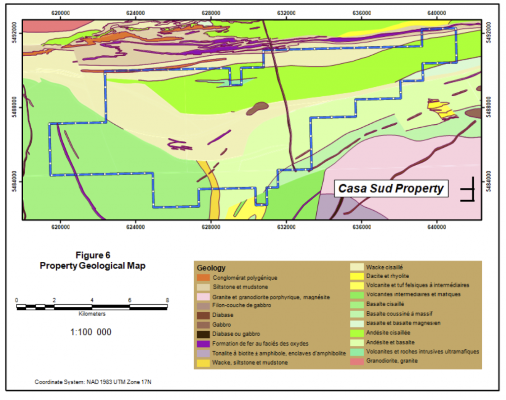
GEOLOGY & MINERALIZATION
The property is located inside the northwestern segment of the Abitibi Greenstone Belt and is part of the North Volcanic Zone. The Casa Berardi area was previously included in the Harricana-Turgeon Through by fundamental regional geology studies produced by the MERN following the discovery of the Casa Berardi deposit (Lacroix S., et al., 1990).
The Abitibi Belt is the most important Greenstone Belt in terms of size and metal content of the Superior Province, which is the Archean core of the Canadian Shield. The Belt is transected along the western side by the Kapuskasing uplift and on the eastern and southern side, by the Grenville Front, both extending along 300 km contact line and representing Proterozoic limits. To the north, volcano-sedimentary sequences are interpenetrated with the Opatica Sub-Province.
The Property encompasses a lithologic context similar to the Cass Berardi deposit. Its exploration history followed the same stages of evolution over a period of time from the 1960 to 1990 where exploration focused on sulfide rich polymetallic deposits similar to the Kidd Creek, Selbaie, or Mattagami deposits discovered in the northern part of the Abitibi belt. Exploration work on the claims was done by companies such as Newmont, Noranda, and Cambior, among others.
Casa South Property
Deposit Model
Casa South Property
Geology Map
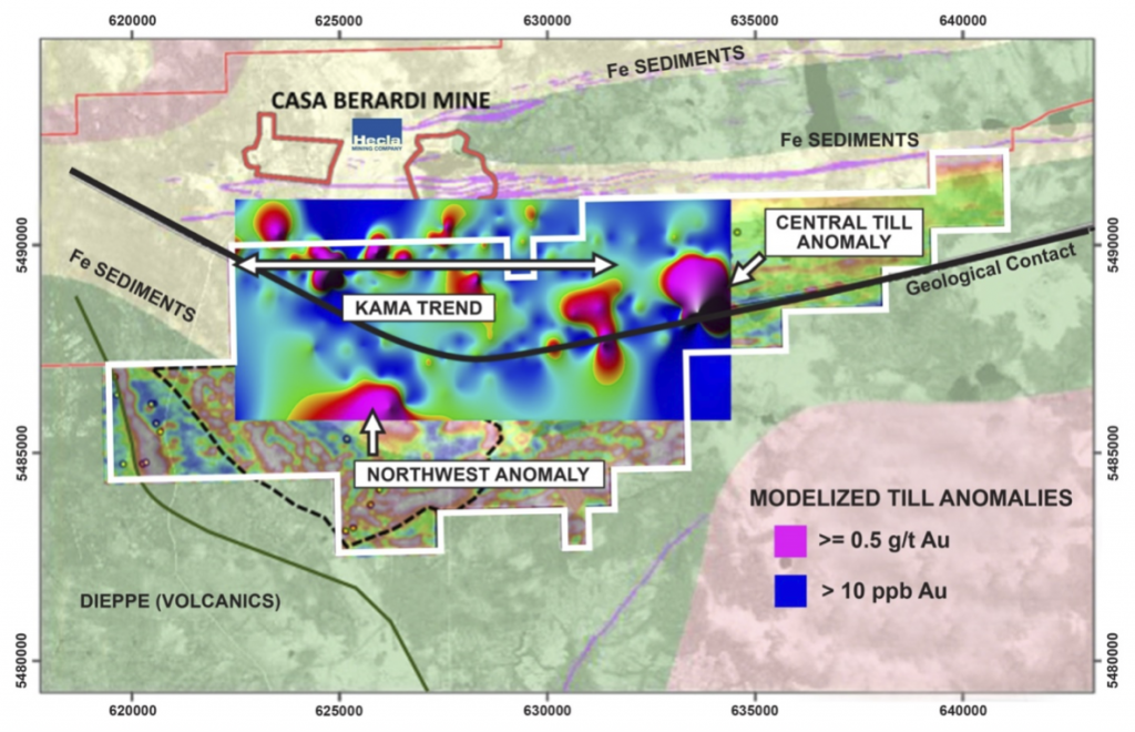
Three main exploration targets have been identified on the Casa South Property. One is a major gold bearing structure south of Casa Berardi Mine called the Kama Trend. Another is the Central Till Anomaly, and the third is the Northwest Magnetic Anomaly defined by geophysics.
Casa South Property
Exploration Targets
EXPLORATION
Exploration results in Quebec are preserved through Assessment reports filed with by the Ministry of Energy, Mines, and Natural Resources (MERN). This exploration history is a summary of work documented in those reports. Note that the work applies to claims that were in staked at that time the work was done and a report may apply only to a portion (a subset) of the current claims that make up the Property.
Exploration Prior to 1970
In 1919, T.L. Tanton mapped the Harricana-Turgeon basin at 4 miles = 1 inch. Tanton’s study area included part of the Casa South Property. After the discoveries of many deposits, mining companies and prospectors evinced considerable interest in the Abitibi and Northern Greenstone belts. In the Property area, interest (late 1950) centered on a broad belt of volcanic-sedimentary Precambrian rocks.
The first work listed on the property in the MRNF files (SIGEOM) belongs to Moneta Porcupine Mines (GM 15689 — GM 10847). They drilled seven holes totaling 2,318 feet in 1959 (5 on the Casa South Property). A preliminary airborne magnetic and electromagnetic survey followed by ground geophysical work indicated the anomalies to be tested. Traces of gold were noted in the assays from two holes.
In 1961-1964 the Province of Quebec conducted geological studies that encompassed part of the Property (RG 116— RP 475).
A geophysical survey was made by United States Smelting, Refining and Mining Co in 1968 (GM 23389) to locate and evaluate conductors located in a previous airborne electromagnetic survey. In the summer of the same year a geochemical sampling program and geological information were carried out (GM 23388). Another EM survey was done in 1969 (GM 24712) and the best anomalies were drilled in 1969 with 3 holes totaling 1,372 feet (GM 24713). Around the same year (1968), SOQUEM, conducts MAG and EM surveys in the western part of the property to check a series of INPUT anomalies (GM 22426 — GM 22409).
Exploration after 1970 – Noranda Exploration
In 1973, Noranda Exploration flew an airborne EM survey on the east side of the property. Two long formational trends dominate the survey area. The northerly one is considered to be an iron formation and the other one to be a volcanic-sediment contact zone previously checked. Some isolated zones were considered for future targets (GM 48987).
In 1974, Noranda did some ground MAG/EM surveys, on a property around Janelle Lake (GM 30470 — GM 30056) and around Casa Lake (GM 29740), and in 1975 south of Casa Lake (GM 31362). Noranda drilled 1 hole, north of Casa Lake in 1975 (GM 31332) and one to the northwest of Janelle Lake (GM 31069).
Another geophysical survey was done on the extension of the project 1-74, in 1977, to evaluate the airborne INPUT electromagnetic anomalies. More ground geophysics was done by Noranda Exploration in 1982 (GM 39695 — GM 39694 — GM 39693) on property 1-82, 2-82 and 3-82. A compilation was done in 1984 on Casa Berardi I (GM 41754) and two unsuccessful attempts were made to drill a hole north of Janelle Lake (GM 41751). A hole was done south of Casa Lake with no significant result (GM 41596). A series of ground MAG/EM surveys are carried out on several properties belonging to Noranda Exploration in 1984 (GM 41398 — GM 41399 and GM 41400), in 1985 (GM 42625 — GM 42626 — GM 42627) and in 1988 (GM 46341).
In 1986, another drill hole was made just north of the Casa Lake (225 m) (GM 44158). An IP survey was done in 1987 on Casa Berardi II property, east of Casa Lake. The 1988 drill program was undertaken to evaluate the Casa Berardi I property of Noranda Exploration in joint venture with Esso Minerals Canada. It included one diamond drill hole for a total of 148.74m (GM 47129). Another campaign of one drill hole on the present property was done by Noranda in 1989, just west of the Theo River (GM 49954). In 1989 Glen Auden becomes a partner with Noranda on several claim groups. They carried out several geophysical surveys between 1990 and 1995 (GM 49955 — GM 66434 — GM 51619 — GM 51618 — GM 51564 —GM 66069 — GM 52553 — GM 53382) and three drill holes (GM 52762). New Legends made a summary of geophysical results between Glen Auden property on the east side of the current property (GM 66431). In 1995, Glen Auden entered a joint venture with Inco and made a geological survey the same year (GM 53777).
Exploration after 1970 – SOQUEM-Newmont-Cambior
In 1976, SOQUEM made a gravity survey on the whole property (GM 33972) and a ground geophysical survey on the Moneta Porcupine works sector (GM 34576) with a geological survey in 1978 (GM 34575) they note that the highest sulphides’ concentrations are in the acid facies in conjecture with intrusives. Following the recommendations contained in the two previous reports, it was recommended to drill 5 holes (GM 35461). In the spring of 1979, 5 drill holes are made. The results were disappointing, all the anomalies were caused by sterile sulphides and graphite (GM 34874). In the same year, a ground geophysic survey was done on the western part of the property (GM 34578).
In 1980-1982 geochemical sampling of sediments associated with Quaternary (Wisconsin) age regional glaciation events (also known as till sampling) became a useful exploration tool to locate buried lode gold exploration targets in the Quebec region. In fact, reports indicate that till sampling was important in the discovery of the Casa Berardi Mine
Based on internal assessment reports, the first till sampling program was conducted on the Property in 1981 by Newmont Exploration in joint venture with SOQUEM. Eight holes were drilled with reverse circulation equipment and the glacial sediments were sampled to bedrock. Bedrock was confirmed by continuing the drilling 1.5 meters into bedrock. Geologically, samples were taken in different glacial stratigraphic units. The goal was to infer a “gold dispersion trail” that might lead to a bedrock gold source. . Sediments from three till sheets were deposited in the Casa Berardi area and on the Property. The earliest glacial event had direct contact with bedrock, and deposited a lowermost till that was comprised of 80 percent local rock. The importance of the lower till is that it was closest to the bedrock source and therefore should be of more interest in lode exploration. Middle and upper deposits of the younger Wisconsin glaciations were also encountered in drilling.
The intersection of at least one gold-bearing till horizon in 6 of the 8 holes outlined a gold dispersion trail in the till which pointed to a gold source on the Casa South Property. A second overburden drilling program was carried out over the untested parts of the original claim block and parts of the new claims areas in an attempt to evaluate the overall gold potential in 1982. A total of 35 holes were drilled and these outlined several more gold dispersion trails in the glacial overburden. After that, magnetic and an EM Maxmin geophysical surveys were completed on the Property (GM 38956).
In 1983, Newmont drilled eleven BQ-holes for a total of 2,381 meters. The sandstone units intersected near the end of hole 83-1 are comparable to that occurring in the hanging wall of gold mineralization at the Casa Berardi Mine according to the author of the report (GM 40407). In 1983, Maxmin and MAG surveys extended the original coverage and provided more detailed results in regions that warranted closer spaced coverage. In the same year, an induced polarization survey was run over four grids. The purpose of the survey was to outline disseminated sulphides and carbonate zones in areas that were not conductive.
In 1986 another drilling campaign was done, totaling 1,548 meters in 6 holes (GM 44445). No significant values of gold were found and another of 2,047.6 meters consisting of 9 holes was drilled the same year (GM 43699) with the similar results. Exploration, in 1987, consisted of an additional 110 line-km of line cutting, 91 250 line-km of MaxMin survey and 92 line-km of proton magnetometer survey (GM 46765). A program of 17 diamond drill holes with a total of 5,767 m of drilling tested the conductors and altered zones along the contact of altered felsic to intermediate volcanics and overlying volcaniclastic sediments that have shown anomalous gold values in previous work (GM 46766).
In 1986, SOQUEM transferred its property’s interest to Cambior which became Newmont. In 1988, a new agreement brought in Sphinx-Goldstack as a new partner in the group. Cambior completed a compilation of all geophysical surveys in 1988 (GM 49283). Magnetic and Maxmin surveys were executed in the southwestern part of the current property by Cambior. These surveys lead to better map the various parts of deformed iron formation affected by intersecting faults (GM 49293). The same year, 197 reverse circulation overburden holes were drilled. Overburden and bedrock were sampled to test for glacially dispersed mineralized boulders indicative of subcropping bedrock gold deposits. The results were considered disappointing by Cambior (GM 49285). This conclusion is supported by negative results obtained from an extensive diamond drilling program that was performed concurrently with the reverse circulation drilling (GM 49284).
Exploration after 1970 – Others
In 1974, the Department of Natural Resources of Quebec made an INPUT MK survey covering the entire region (DP 260) and revised it in 1976 (DP 760). Also in 1974, Hudson Bay Exploration flew an EM survey over the west part of the Property. A large number and variety of electromagnetic conductors were detected (GM 30839). Some ground EM surveys were done in 1975 (GM 31720 — GM 31662) followed by drilling in 1976. Large bands of graphitic rocks were found (GM 30808).
In 1975, Belmoral Mines acquired some ground on the basis of the MK Input done by the Department of Natural Resources of Quebec. A geoscientific compilation is made (GM 61101). In the same year, Patino Mines, made some MAG-EM surveys in the central part of the property (GM 31732 — GM 31684) and a ground geophysical survey was also undertaken by Cominco on some claims south of Casa Lake (GM 31682). A drill hole was done by Canadian Nickel Company in the center of the Property (GM 30812).
In 1980, three holes were drilled on the Audet claims for a total of 33.53 meters of drilling. Areas of conglomerates were reported in the southern part of the Property. In 1981, 4 more holes were drilled in the same area by Selco Mining Corp. for a total of 103.63 meters (GM 38260). A ground VLF and Mag survey was done one those claims in 1982 (GM 39221) and another drill hole drilled in 1984 (GM 41536).
In 1982 a pedogeochemistry report was filed by the Ministry of Energy, Mines, and Resources (DP 896). In this report it can be noted that the Casa Berardi Mine area corresponds to a large gold anomaly. A series of complementary reports followed in 1985 (MB 85-58 — MB 85-57 — MB 84-23).
Fort Knox Minerals was successful in acquiring two properties in the Casa Berardi area in 1985. A compilation of the properties was done the same year (GM 42223).
Ingamar Explorations completed a VLF survey on a property they acquired in 1985. This Property covered the central part of the Casa South Property.
In the west part of the Property, Ressources La Pause made a compilation on their recently acquired claims (GM 45112) and a geological survey (GM 45111). Geological mapping confirmed the presence of geological formations favorable to polymetallic mineralization (Au, Ag, Cu, Zn).
In 1984, Vior completed a four hole drilling program for a total of 739.4 m just northwest of the Casa South Property (GM 42013) after some ground geophysical surveys (GM 42012 — GM 42445) and a geological compilation (GM 41701). In 1985, Vior carried out another four hole drilling campaign for a total of 580.4 m. No significant gold values were reported (GM 42509).
In 1986, Oasis Resources carried out a 12-hole drilling campaign, including 10 on the Casa South Property for a total of 2,200 m at the eastern end of the Property, in addition to a geological compilation and a geophysical survey (GM 43452).
Mineta Resources made a ground geophysical survey in the central part of the Property in 1985 and the interpretation in 1986 (GM 41981 — GM44281), plus an IP survey the same year (GM 43177).
In 1986, a total of three BQ diamond drill holes (571.20 m) were done on the Property of Multinational Resources. All holes encountered andesitic and dacitic metavolcanics. This area was located at the north center border of the Casa South Property.
Golden Tag and Achates Resources performed an IP survey, in 1986 to explain some horizontal loop electromagnetic anomalies on the south of Casa Lake area (GM 43605). The survey has detected seven chargeability anomalies (GM 43619). The Golden Tag Property then passed to the hands of the Mirandor Exploration which carried out a geological and compilation survey in 1987 (GM 46582) with an IP and magnetic survey (GM 46581-GM 46580), and a drilling campaign in 1988, with 5 holes (817 m). All of the analytical results revealed negligible gold content, thus leaving the source of gold till anomalies unexplained (GM 47373). This area was taken over by Cross Lake Minerals, which carried out a geophysical survey in 1993 (GM 52238). The same year, a 4-hole diamond drill program was carried out for a total of 584.5 meters (GM 66435). In 1995, Cross Lake signed a Joint Venture with Inco, and the same year made a geophysical and a geological survey (GM 53538 — GM 53524).
Ramcor Resources, which had a property between Lac Janelle and Lac Raymond, conducted a ground geophysical survey in 1986. This survey outlined two strong, but partially defined conductors located in an area of strong local magnetic gradient (GM 43116).
Since the discovery of the Golden Pond deposits in the township of Casa Berardi and the Golden Hope prospect in the township of Estrades, all this part of the Abitibi became the focus of intense exploration work.
The Province of Quebec, in 1987, completed the mapping of the Collet and Laberge townships, and of previously unexamined sectors of the Dieppe and Casa Berardi townships. A first phase of work was undertaken during 1986. The aims of this study were to characterize the different lithologies encountered, to establish the stratigraphy and a preliminary tectonic model capable of reconciling the geological and geophysical observations, and finally, of recognizing the main metallotects (DP 87-17 and MB 89-43).
In 1999, 1232448 Ontario Inc. conducted geophysical surveys on two areas within the current property (GM 57312). In 2000, Ressources Frenchie conducts a geophysical survey in the center of the current Property (GM 57910). In 2001, Cancor Mines completed a geoscientific compilation of the Joutel-Casa Berardi area including two maps; a Vertical gradiant and Input anomalies map and a geological compilation map.
The 2005 Mines Aurizons exploration program focused on the First Explorers Alliance/Sea Green Capital agreement which concerned a group of three claims located immediately south of the Casa Berardi East Mine. A six hole, 602 meter drilling program was executed. Five holes were located for cross cutting the faulted contact between the Raymond volcanic domain and the Taïbi sedimentary domain which is considered as the best control for gold mineralization. Only hole CBS-05-172, located 200 meters from a previous intersection returned 0.3 g/t Au over 11 meters, in association with a maximum concentration of arsenic of 7,800 ppm (GM 62957). A good summary of the work carried out around the Casa Berardi Mine, by Mines Aurizon, from 2003 to 2006, was made the same year (GM 62472).
In 2006, Sea Green Capital completed an IP survey. The survey (GM 62989) was carried out on four separate grids, but only one grid overlayec the Casa South Property. In 2011, See Green Capital, covered the southeastern part of the Casa South Property with a heliborne with a geophysical survey (GM 67846).
Also, in 2006, in the northwest corner of the current Property, Antoro Resources conducted a magnetic survey to follow a possible iron formation in this sector (GM 62567). They followed up with a sampling campaign in 2010. Assays did not include any significant value for the 19 samples collected (GM 65314). In 2010, Mainstream Minerals carried out a heliborne geophysical survey over the northeastern part of the Casa South Property.
Between 2013 and 2018, GREG Exploration completed several geological, structural and geophysical heliborne surveys on the Property (GM 68531, GM 67505, GM 68805, GM 68804, GM 68803, and GM 70450). They compiled a significant database of information from assessment reports, government reports, and other information from historic exploration that was done on the Property over a number of decades. Over a period of about 45 years, over 23,990 meters of core drilling in 119 drill holes and 43,700 meters of reverse circulation drilling in the glacial till in 206 holes was done on the Property. Greg compiled a significant database of information. Note this exploration was, for the most part, done by operators on smaller subsets of claims that make up the current claim package.
The interpretation data obtained from a multi-platform geophysics survey using VLF (Totem), Quadrimag and Afmag was used by Greg to model the geology and structures on of the Property, supported by historical surface sampling and drilling data. The database of information collected and the interpretation of the collective data, along with the recent geophysics surveys conducted by Greg, has led to the prioritization of exploration targets on the Property and enhances the potential for discovery. Emgold acquired this database when it acquire the Property from Greg.
In 2019, Emgold completed a 3,009 m core drilling programs at Casa South. Eight holes explored the Kama Trend. The other hole tested a prospect elsewhere on the Property. Emgold is also completing a drone survey on the Property, with the goal of better defining structures and to better define exploration targets for drilling.
Emgold has also re-evaluated the glacial till sampling programs that were completed on the Property. The first critique was summarized in the 2019 Emgold NI 43-101 Technical Report. Since then, additional work has confirmed the presence of a deep glacial trough that trends southwest through the central part of the claim block. In addition, several gold anomalies occur in the glacial sediments on the Property in till situated within 20 meters of bedrock. This information, along with interpretations of historic and current geophysical surveys and geologic data, will be used to develop future exploration drill targets.
TECHNICAL REPORT
Emgold completed an a technical report titled, “NI 43-101 Technical Report, Casa Sud Property NTS 32E06/32E11, Northwestern Quebec, for Emgold Mining Corporation and Greg Exploration, Demers and Theberge, March 8, 2019”
QUALIFICATIONS
Mr. Robert Pease, CPG, acting as the Qualified Person for Emgold, has reviewed and approved the information on this webpage.
REFERENCES
Technical Report for the Casa Berardi Mine, Northwestern Quebec, Canada, NI 43-101 Report, for Hecla Quebec, Archambault-Giroux, De Los Rios, Blier, Roy, and MacDonald, Effective Date December 31, 2018, Filed April 1, 2019
NI 43-101 Technical Report, Casa Sud Property NTS 32E06/32E11, Northwestern Quebec, for Emgold Mining Corporation and Greg Exploration, Demers and Theberge, March 8, 2019
DISCLAIMER
Readers are cautioned to review the Disclaimer Page on this website for qualifications that may be applicable to the information contained on this Property Page, including forward looking statements, definitions of mineral resources and reserves, etc. Readers are also cautions to review Emergent's financial statements and management’s discussion and analysis available on this website or at www.sedar.com for additional information.