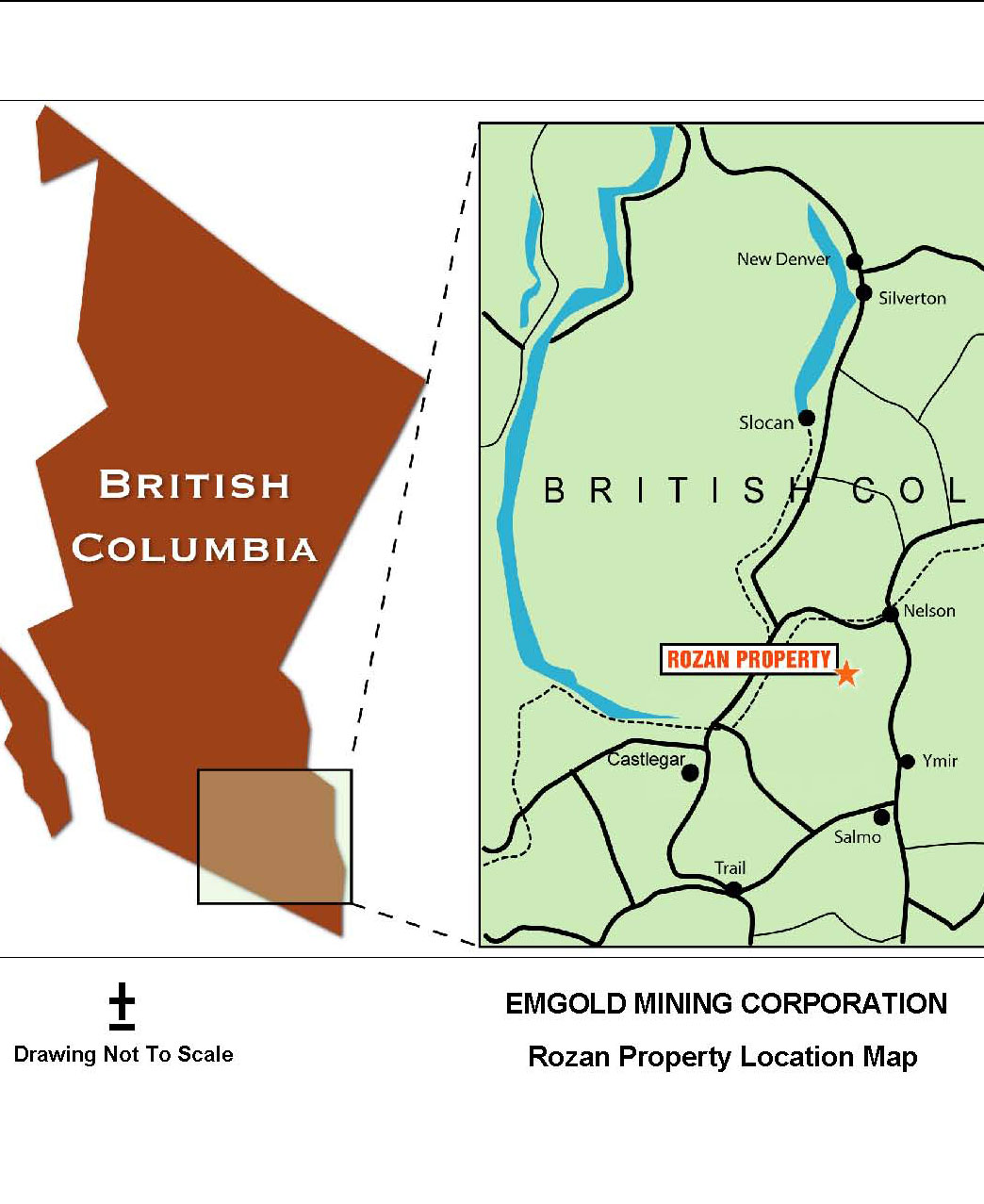
| Location | British Columbia |
| Location Details | 10 km southwest of Nelson |
| Type of Project | Early stage exploration |
| Number of Claims | 32 mineral tenures |
| Est. Property Size | 1,950 ha |
| Emgold Ownership | 100% |
| Underlying Royalties | 3% NSR of which 2% can be purchased for C$1.0 million |
| Exploration Completed | · Soil and rock chip sampling
· Trenching · Geophysics · 18 diamond drill holes drilled totaling 1,907m from 2000 to present |
| Exploration Targets | 10 gold anomalies |
| Technical Report | None |
| Resources | None yet defined |
| Highlights | · Strategic property located south of and abuts the Kena Property, owned by Prize Mining Corporation. The Kena Property as a indicated resource of 24.9 million tonnes at an average grade of 0.60 grams per tonne gold containing 481,000 ounces of gold and a inferred resource of 85.8 million tonnes at an average grade of 0.48 grams per tonne gold containing 1,318,000 ounces of gold
· Property held until 2023 without additional work · Potential for a Au and Ag, plus other base metals |
The Rozan Property is an early stage poly-metalic property located in the Nelson Mining District of B.C. It is located in a region of historic mining activity and is part of a large north-south geologic trend containing occurrences of gold, silver, molybdenum, tungsten, copper, and other mineralization. Emgold has completed initial drilling on the Property intersecting gold mineralization. Multiple exploration targets have been identified, including the Main Zone, where historic mining occurred.
SUMMARY
The Rozan Property (“Rozan” or the “Property”) is an early stage poly-metallic property located in the Nelson Mining District and is located approximately 10 kilometres southwest of Nelson, B.C. William Rozan staked the area in 1928 and operated a small scale high grade gold mining operation on the property until the early 1970’s. The Property consists of 32 mineral claims covering an area of 1,950 hectares. It is located in a region of historic mining activity and is part of a large north-south geologic trend containing occurrences of gold, silver, molybdenum, tungsten, copper, and other mineralization.
The Property is located south of and abuts the Kena Property, owned by Prize Mining Corporation. The Kena Property as a indicated resource of 24.9 million tonnes at an average grade of 0.60 grams per tonne gold containing 481,000 ounces of gold and a inferred resource of 85.8 million tonnes at an average grade of 0.48 grams per tonne gold containing 1,318,000 ounces of gold (source: Technical Report for the Kena Project, Nelson B.C., Giroux and Park, Report Date January 16, 2017, Effective Date January 7, 2017, Revised Date: June 2, 2017). Note that the presence of the resource on the Kena Property does not imply a similar resource will be delineated on the Rozan Property. However, geological mapping of the Rozan, Stewart, and Kena Properties does show similar geologic structures that overlap on these properties.
Rozan
Location Map
Rozan is underlain by a sequence of meta-sedimentary and meta-volcanic rocks of the Early Jurassic Archibald and Elise formations, respectively. The units are part of the Rossland Group and are highly prospective for hosting economic mineralization (gold, molybdenum, tungsten, copper, and silver), especially where the rocks are intruded by later Mid-Late Jurassic granite-granodiorite bodies correlative with the Nelson Intrusions. The claims straddle a NW-SE trending package of sheared rocks proximal to the Silver King Shear Zone and cored within the Hall Creek Syncline. Emgold is currently focused on exploring for high-grade gold veins and bulk mineable disseminated gold zones.
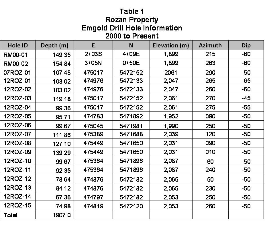
Exploration by Emgold to date has included geological mapping, geochemical sampling and geophysical surveys along with diamond drilling. Drilling to date includes 18 holes totaling 1,906.8 metres.
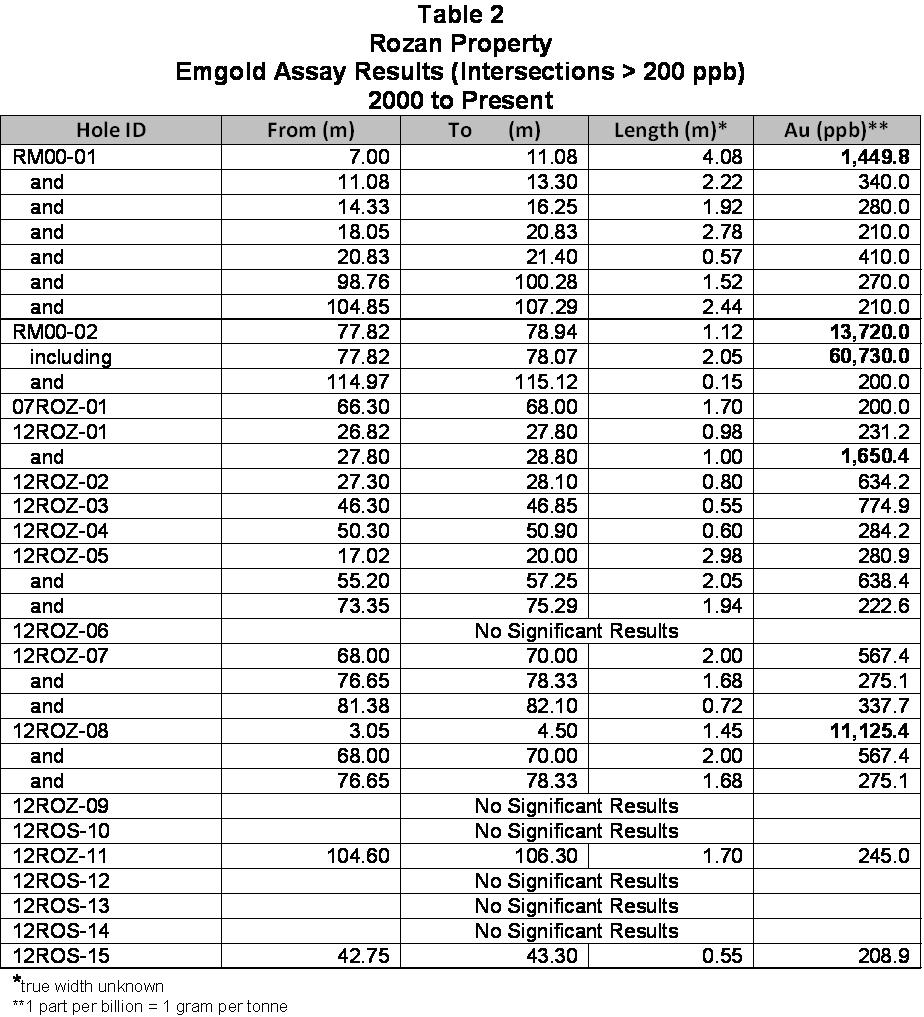
Highlights of the drilling to date (intersections over 1.0 gram per tone) include:
- Hole RM00-01 returned 1.45 grams per tonne gold over 4.08 metres (7.00 to 11.08 metres);
- Hole RM00-02 returned 13.72 grams per tonne gold over 1.12 metres (77.82 to 78.94);
- Hole 12ROZ-01 returned 1.65 gram over 1.00 metres (27.80 to 28.80 metres); and
- Hole 12ROZ-08 returned 11.13 grams per tonne gold over 1.45 metres (3.05 to 4.5 metres).
Details on the drilling our outlined below. The Property has the potential for high-grade gold veins, bulk mineable disseminated gold zones, as well as discovery of other minerals.
LOCATION AND OWNERSHIP
Rozan is located ten kilometers southwest of the community of Nelson and 12 kilometers northwest of the historic mining town of Ymir, in the Red Mountain area of southeastern British Columbia, Canada, as shown on the Location Map. The Property consists of 1,950 hectares, representing 32 mineral claims. It is centered at 49 degrees 24 minutes north latitude and 117 degrees 20 minutes west longitude on NTS map sheet 82F06.
The Property is currently 100 percent owned by Emgold, subject to a three percent underlying Net Smelter Royalty (NSR) held by Jack and Eric Denny (the “Denny Royalty”). Emgold currently has the right to acquire two thirds (a two percent NSR) of this three percent NSR by making a cash payment of CDN $1,000,000 to the Denny’s. Emgold also has first right of refusal on the remaining one third (a one percent NSR) of the three percent NSR, should the Denny’s elect to sell it to a third party.
HISTORIC EXPLORATION WORK BY OTHERS PRIOR TO 2000
The Rozan Property was initially staked by William Rozan in 1928 and was worked until 1972. He developed six underground workings and did about 600 metres of trenching. A small high grade mining operation yielded a reported 146 tons of ore containing 215 ounces of gold with small amounts of silver, lead and zinc. In 1972, William Rozan passed away and the property reverted to the public domain.
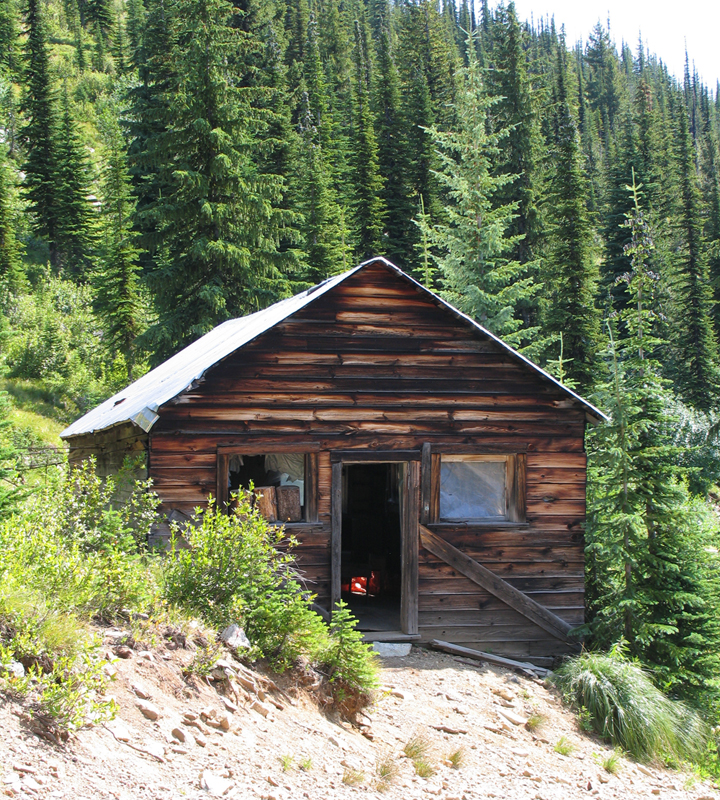
Bill Rozan’s
Historic Cabin
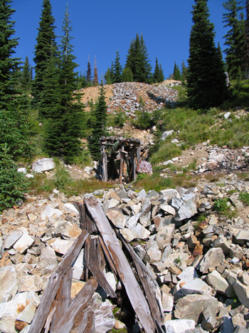
Rozan
Historic Main Vein Portal
Prospectors Eric and Jack Denny and Frank Cameron acquired the Property in 1974. The next year, additional claims were added to the group. They rehabilitated the main workings and repaired the access road.
In 1983, Patrick Resources Corporation acquired the Property through an option agreement. Their compilation report outlines the collection of 11 rock samples focused mainly on the underground mine and ore dump and includes several detailed surface and underground maps. The best assay collected came from a stockpile grab sample at the main portal that returned 2.47 oz/ton gold (Source, Santos P.J., Report on the Rozan Project, Patrick Resources, 1983).
In 1983, Rex Silver Mines Ltd. conducted a reconnaissance program consisting of geology, prospecting, and stream silt sampling on the HC 1-4 mineral claims. During 1984, Rex Silver continued the reconnaissance work and collected several non-anomalous pyritic samples (Source, Aussant, C.H., Geological and Prospecting Report on the HC 1-4 Mineral Claims, Rex Silver Mines Limited, Assessment Report 11782, 1983 and Prospecting and Geochemical Report on the HC 1-4 Mineral Claims, Rex Silver Mines Limited, Assessment Report 13489). Additionally, Greenwich Resources Inc. geochemically surveyed the Actinolite claims and collected 48 rock samples and 99 stream sediment samples (Source, Sinden, G.W. and Evans, D.S., Geochemical Survey and Prospecting Report, Actinolite 5/6 Claims, Greenwich Resources, Inc., Assessment Report 12984).
In June 1986, Lacana Mining Corp. completed three days of traversing on the Property collecting 14 rock and 51 ‘B’ horizon soil samples. Anomalous gold soil samples were associated with epidote altered andesites which assayed up to 210 ppb gold (Source, Johnston, R.J., Geochemical Assessment Report on the Rozan Mineral Claim, Lacana Mining Corp. Assessment Report 15277).
In October 1986, Hiawatha Resources Inc. collected six representative rock and 194 grid based soil samples from the top of Red Mountain to below Rozan’s historic cabin. Strongly anomalous gold in five of the rock samples ranged from 0.15-0.77 oz per ton and over 21 soil samples returned more than 100 ppb gold. During 1988 to 1992, Hiawatha optioned the Rozan claim group and conducted property wide mapping and the collection of some 1,000 soil samples. The soils successfully outlined a 600 by 600 meter gold-in-soil anomaly where the best result was 560 ppb gold (Source, Sevensma, P.H., Geological and Geochemical Report, Rozan Property, Hiawatha Resources Inc., Assessment Report 19357; Geochemical Report, OGG Property, Hiawatha Resources Inc., Assessment Report 19357, 1989; Geochemical-Geological Report, Rozan and OGG Properties, Hiawatha Resources Inc., Assessment Report 21730, 1990; Geochemical Report, Rozan and OGG Properties, Hiawatha Resources Inc., Assessment Report 21730, 1991; and Geochemical Report, Rozan and OGG Properties, Hiawatha Resources Inc., Assessment Report 22568, Hiawatha Resources Inc., 1992).
Also during 1988, Geostrategic Consultants conducted a detailed magnetometer survey of the Honky Tonk claim group (correlating with the Flying Dutchman occurrence) to attempt to identify the source of mineralization. The survey was unsuccessful in identifying a possible source (Source, Evans, D.S., Magnatometer Survey on the honky Tonk Claim Group, Geostrategic Consultants, Assessment Report 18939, 1988).
In the summer of 1996, Yukon Revenue Mines investigated the Property attempting to ascertain the source of Hiawatha’s gold-in-soil anomaly. The exploration work consisted of geological mapping, soil sampling and a detailed analysis of the surficial materials (Source, Craig, L.O., Geochemical and Geological Report on the Rozan Group, Yukon Revenue Mines Limited, Assessment Report 24843, 1997).
In summary, from 1983 to 1997, exploration of the Property consisted primarily of geological mapping and geochemical (soil and rock) sampling, which resulted in the definition of two veins with gold values reported to be up to half-ounce per ton. In addition, stockwork veins were discovered in granodiorite.
The historic exploration work is documented in assessment reports files with the B.C. Ministry of Energy and Mines. Historic sample matches closely with modern exploration results. Historic data acts as a guide for ongoing exploration activities.
GEOLOGY AND MINERALIZATION
The Rozan Property is underlain by Early Jurassic Rossland Group volcanic (Elise Formation) and sedimentary (Archibald Formation) rocks, which have been intruded by the Nelson Batholith, Tertiary dikes and small stocks. Quartz veins have cut the Nelson Batholith and older formations. A zone of silicification in the intrusives is normally developed on both sides of these quartz veins. Lamprophyre dikes also cut across the Nelson Intrusives.
The quartz veins appear to follow two directions, northwest and northeast. The northwest direction is the regional trend, which is also followed by the lamprophyre dikes. The northeast trend of the larger quartz veins is reflected by the gold soil geochemistry contours.
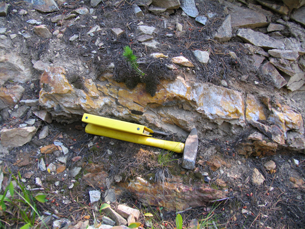
Rozan
Quartz Vein in Trench
HISTORIC EXPLORATION BY EMERGENT AND OTHERS SINCE 2000
During 2000, Emgold acquired the Rozan Property and collected 169 ‘B’ horizon soils, 19 rock chip samples, conducted a magnetometer geophysical survey amounting to 5.8 line kilometres and diamond drilling. Three BQ holes were completed on two primary targets (hole RZ00-01 tested a granodiorite ridge hosting sheeted and stockwork quartz veining and hole RZ00-02 tested the extension of the main Rozan vein at depth). RZ00-01 returned 1.45 grams per tonne gold over 4.08 meters. Hole RZ00-02 which returned 60.73 grams per tonne gold over 0.25 meters (see press release dated December 4, 2000). Assaying was done by ACME Analytical Laboratories in Vancouver following standard procedures.
In the winter of 2003, Emgold retained Fugro Airborne Surveys Corp. flew 161 line kilometres along NE-SW oriented flight lines utilizing a DIGHEM V EM-MAG geophysical system covering the majority of the Property. The survey identified 167 anomalies, with 88 being traceable to discrete bedrock sources often indicative of conductive sulphides and several discrete weak conductors were located.
In late 2004, Emgold completed a follow-up soil sampling program over the airborne anomalies. A total of 333 soil samples and nine rock samples were collected. Several correlations were discovered between areas of anomalous magnetic and electromagnetic features, areas of mineralized veining and alteration mapped during prospecting and gold-in-soil geochemical anomalies.
In 2007, a third diamond drill hole was undertaken by Emgold. Hole 07ROZ-01 was drilled to a depth of 104.29 metres and was designed to further test the extension of the main Rozan Main Vein. The highest assay result from this drill hole, which failed to intercept the vein, was 0.2 grams per tonne gold over 1.7 metres (see press release dated January 11, 2008). Assaying was done by ACME Analytical Laboratories in Vancouver following standard procedures. In total, three holes totaling 410 meters have been drilled at Rozan.
In January, 2010, Emgold completed a Lease and Option to Purchase Agreement with Valterra Resource Corporation who owned the nearby Star and Toughnut Properties. All previous soil sampling campaigns on the Property were digitally compiled into a single database (1,637 samples) and tied to corrected UTM, NAD83 coordinates based on available grid stations identified/found from the old grid. The historic soil geochemical data was scanned and optically recognized using analytical certificates from assessment and company reports.
Geological mapping indicated that the Jurassic aged Nelson Intrusions consisting of granodiorite and porphyritic diorite extend further north than previously thought, expanding the potential for further precious and base mineralization within and adjacent to the intrusives and Elise Formation mafic to intermediate tuffaceous rocks. The mapping also revealed that the Mount Verde fault consists of an approximately 200 metre wide breccia zone with local zones of extensive shearing. Coincident with the Mount Verde fault is spotty but strongly anomalous gold and molybdenum in soils.
Soil sampling, comprising approximately 150 samples, was completed to infill a gap in the historic soil sampling coverage and to expand the soil survey to the north. Results of the 2011 soil sampling compiled with previous soil surveys has defined an area 1.8 by 1.6 kilometers in size with several gold anomalies based on a 55 part per billion gold grade contour. The gold in soil anomaly appears to have two preferential orientations being NW-SE and NE-SW. The northwest orientation is related to the contact between Elise Formation tuffaceous rocks to the west and granodiorite to the east. Gold values in soils ranged from 0.300 to 2,625 parts per billion. Mapping was completed for gold, arsenic, molybdenum, iron, tungsten, and manganese. Assaying was done by Acme Labs of Vancouver, and independent laboratory, following standard laboratory procedures, with standard quality control measures.
A total of 10 gold anomalies were identified by Valterra. A NW-SE trending gold soil anomaly (Target A) extends for some 1.8 kilometres and is up to 200 meters wide (true width is unknown). Along the surface trace of the Mount Verde fault there is a strong anomaly (Target B) identified by gold, tungsten, arsenic, and manganese in the soils. The remaining gold soil anomalies are generally NE-SW orientated and are considered related to high grade or sheeted quartz vein gold mineralization (most of which remain unexplained) on the property.
Of the NE ‘trends’, three Trends C, D and G appear to be the most significant. Trends C and D are two sub-parallel NE trending gold in soil anomalies located within granodiorite and may suggest that the sheeted quartz vein system located at the NE end of the soil anomalies extends some 500 meters further to the SW. Trend G appears to originate at the historic Rozan workings and extends some 450 meters to the SW.
Valterra recommended that additional geological mapping be completed initially on five soil anomalies (A-D and G). They also recommended geological sampling and mapping be extended to the entire property. Targets are to be followed up with a core drilling program to explore the extent of mineralization to depth. (Source, McGrath, B. and Baker, B., Prospecting and Airborne Geophysical Interpretation, Valterra Resource Corporation, Assessment Report 32128; and Payne, C., 2011 Geological Mapping and Soil Sampling Report, Valterra Resources, Assessment Report, 2011).
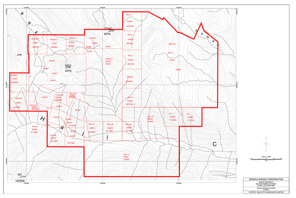
In 2012, the Property was returned to Emgold when Valterra was unable to meet its work commitments. Subsequently, Emgold completed 1,495.3 metres of BTW size diamond core drilling in 15 drill holes on the Property focusing on gold exploration targets. The 2012 diamond drilling program continued to test the Main Vein Zone, where historic mine workings are located. The vein was considered open to the north and south, and to depth. Drill holes 12ROZ01 to 12ROZ04 and 12ROZ06 tested the extents of the Main Vein. The Sheeted Vein Zone was further tested by holes 12ROZ07, 12ROZ08 and 12ROZ09. In addition, drill holes 12ROZ10 and 12ROZ11 tested a soil geochemical trace to the north from the area previously tested within the Sheeted Vein Zone. The Mount Verde Fault and associated West Vein Zone were tested with drill holes 12ROZ05, and 12ROZ12 to 15, respectively.
The Main Vein Zone drilling returned several elevated gold values, with a high of 1,650.4 parts per billion (1.65 grams per tonne) gold over 1.00 metre from hole 12ROZ01. Hole 12ROZ-06 was collared 150 metres to the south of holes 12ROZ03 and 12ROZ-04, to test the Main Vein. Hole 12ROZ-06 drilled through silicified granite with narrow quartz veins in places, but failed to return significant values of gold. This indicates that the Main Vein structure might continue in this direction. Further testing may be required to verify the extent of the Main Vein.
Drilling within the Sheeted Vein Zone returned the highest gold value of 11,125.4 parts per billion (11.13 grams per tonne) over 1.45 metres from hole 12ROZ08. This was a very shallow intercept in the drill hole, and reflects the narrow quartz veining in altered and pyritic granite mapped at surface in this area. Further testing of this area has potential to reveal additional areas of higher-grade gold intercepts in bedrock.
Drilling of the Mount Verde fault and associated West Vein Zone returned elevated values from hole 12ROZ-05 only. A high of 638.4 parts per billion (0.63 grams per tonne) gold was returned from a 2.05 metre sample from 55.20 meters to 57.25 meters, an interval that contained quartz carbonate veining within a weakly crackly brecciated andesite. This may be part of the mapped regional scale fault tested in this drill hole. The West Vein drilling did not intercept any significant structure that might suggest either a fault or vein system is located within the area tested.
Table 1 and 2 below provide information on drilling programs conducted by Emgold to date.
Since acquiring the Property in 2000, Emgold and others have completed geological mapping, conducted geochemical sampling and geophysical surveys, and completed small drilling programs. This has resulted in the discovery of new mineralized structures while also confirming the presence of subsurface mineralization.
Soil and rock geochemistry sampling of quartz and quartz-sulphide veins and veinlets identified areas of elevated gold values. Both low grade sheeted or stockwork veining and higher grade quartz-sulphide veining (the Main or Rozan Vein) are present. Intrusive-related gold occurrences may also exist on the property. Exploration results also suggest that there is a correlation between areas of elevated gold in soil, anomalous airborne geophysical survey data and veining and alteration.
A DIGHEM electromagnetic-resistivity-magnetic survey indicates the presence of a large magnetic high area on the western margin of the property. Higher gold soil geochemical values were associated with this magnetic high.
Drilling results indicate that low grade stockwork veins are present, with quartz-pyrite veining in granodiorite ranging in width from 0.5 to 2.0 centimeters. Drilling also indicated the presence of high grade gold vein mineralization. Thus far, exploration indicates that the Rozan Property has the potential to host both high-grade gold in individual quartz veins and stockwork style disseminated gold in quartz vein systems. Exploration also shows that the Rozan Main Vein is open at depth. Other types of polymetallic mineralization may also be present.
EMERGENT”S QUALITY ASSURANCE AND QUALITY CONTROL PROGRAM
Emgold’s geologists utilized a strict quality assurance plan during the exploration programs that included communication with contractors about the needs for appropriate quality assurance, procurement of supplies and services capable of delivering the desired level of quality, sample handling to ensure integrity, inspection and testing to ensure that all work met or exceeded quality criteria, using methods that reduced the potential for errors, proper training of staff, and statistical analysis that ensured quality criteria were met. The Company completed drill core logging and processing at its facility in Salmo, BC. Samples were shipped to Acme Analytical Laboratories (“Acme”), an independent assay laboratory, in Vancouver for analysis. Acme Vancouver is ISO 9001 Certified. The exploration program was supervised by Perry Grunenberg, P.Geo., a Qualified Person as defined in National Instrument 43-101.
The assay laboratory cataloged all samples, maintained complete chain of custody throughout the analytical process. All sample preparation was done at the laboratory by their staff following standard procedures. As part of their quality assurance, the laboratory incorporated assaying standards, test blanks, and duplicate analyses of samples, and included those results in final reports. The final signed reports completed the chain of custody process. Thus far, no factors of any kind have been encountered in sampling programs conducted by Emgold on the Rozan Property that could materially affect the accuracy or reliability of Emgold’s sample data. All assay results to date have been tabulated and reviewed.
DISTRICT EXPLORATION POTENTIAL
Rozan is located in a region of much historic mining activity, with the Ymir, Erie, Sheep Creek and Nelson districts being sites of extensive exploration and production for over 100 years. Rozan is part of a large geologic trend of gold, silver, molybdenum, tungsten, copper, and other mineralization (Silver King Shear Zone). The trend contains:
- Emgold’s Rozan Property (gold, silver, molybdenum, tungsten)
- Emgold’s Stewart Property (gold, silver, molybdenum, tungsten)
- Prize Mining Corporation’s Kena Property (gold)
- Margaux Resource Corporation’s Jersey Emerald Property (tungsten, lead-zinc, molybdenum) – past producting mine
- Armex Gold Corporation’s Yankee Dundee Property (gold)
- Valterra Resource Corporation’s Swift Katie Property (copper)
The Property is located south of and abuts the Kena Property, owned by Prize Mining Corporation. The Kena Property as a indicated resource of 24.9 million tonnes at an average grade of 0.60 grams per tonne gold containing 481,000 ounces of gold and a inferred resource of 85.8 million tonnes at an average grade of 0.48 grams per tonne gold containing 1,318,000 ounces of gold (source: Technical Report for the Kena Project, Nelson B.C., Giroux and Park, Report Date January 16, 2017, Effective Date January 7, 2017, Revised Date: June 2, 2017). Note that the presence of the resource on the Kena Property does not imply a similar resource will be delineated on the Rozan Property. However, geological mapping of the Rozan, Stewart, Kena and other properties does show similar geologic structures that overlap on these properties.
RESOURCES AND RESERVES
Rozan is considered an early stage property. No NI 43-101 compliant resources have been defined for the property at this time.
MINING
Exploration would target high grade veins and disseminated gold deposits suitable for mining by either surface or underground methods. Selection of mining methods would be determined following exploration and economic studies.
METALLURGY
Selection of a metallurgical process would be determined following additional exploration activity, metallurgical test work, and economic studies.
CONCLUSIONS
The Rozan Property is favorable for gold exploration because mineralization is present and new veins have been delineated from recent exploration. Also, it is part of a regional trend of mineralization and potential exists for discovery of polymetallic mineralization.
The development strategies could include advancing Rozan as a stand alone exploration project or alternatively, and subject to agreements with other companies, combining the Rozan Property with other properties in the region to create a larger regional exploration program.
QUALIFICATION
Technical information included on this web page and been reviewed an approved by Perry Grunenberg, P.Geo., a Qualified Person as defined by National Instrument 43-101.
REFERENCES
Aussant, C.H. (1983): Geological and Prospecting Report on the HC 1-4 Mineral Claims, Nelson Mining Division, BC; Rex Silver Mines Limited, Assessment Report 11782.
Aussant, C.H. (1984): Prospecting and Geochemical Report on the HC 1-4 Mineral Claims, Nelson Mining Division, BC; Rex Silver Mines Limited, Assessment Report 13488
Blanchflower, J.D. (1983): Exploration Proposal for the Rozan-Golden Eagle Property; Unpublished Report.
BC Annual Reports: 1946-ppA141-142; 1953-pA114; BC EMPR.
Craig, L.O. (1997): Geochemical and Geological Report on Rozan Group, Nelson Mining Division, BC; Yukon Revenue Mines Limited, Assessment Report 24843.
Demarchi, D. A. (1996): An Introduction to the Ecoregions of British Columbia; Wildlife Branch Ministry of Environment Lands and Parks Victoria British Columbia.
Evans, D.S. (1988): Magnetometer Survey on the Honky Tonk Claim Group, Nelson Mining Division, BC; Geostrategic Consultants, Assessment Report 17662.
Evans, D.S. (1989): Geological and Geochemical Studies, Actinolite 6 Claim, Honky Tonk Claim Group, Nelson Mining Division, BC; Geostrategic Consultants, Assessment Report 18939.
Fyles, J.T. (1967): Geology of the Ainsworth-Kaslo Area British Columbia; BC Department of Mines, Bulletin 53.
Granger, R. (1995): Miscellaneous for Yukon Revenue Mines on Rozan Group; Yukon Revenue Mines, Unpublished Report.
Grunenberg, P. (2001): Geological, Geophysical, Geochemical and Diamond Drilling Report on the Rozan Property, Nelson Mining Division, BC; Emgold Mining Corporation, Assessment Report 26606.
Grunenberg, P. (2005): Geological and Geochemical Report on the Rozan Property, Nelson Mining Division, BC; Emgold Mining Corporation, Assessment Report 27702.
Gruenberg, P. (2013); Rock Sampling, Soil Sampling, Diamond Drilling Report on the Rozan Property, Nelson Mining Division, B.C., Emgold Mining Corporation, Assessent Report No. TBD.
Höy, T. and Andrew, K. (1988): Rossland Group, Nelson Map Area, Southeastern British Columbia; BC Ministry of Energy, Mines and Petroleum Resources, Geological Fieldwork 1988, Paper 1989-1.
Höy, T. and Dunne, K.P.E. (1998): Geological Compilation of the Trail Map-Area, Southeastern British Columbia; BC Ministry of Energy and Mines, Geoscience Map 1998-1.
Johnston, R.J. (1986): Geochemical Assessment Report on the Rozan Mineral Claim, Nelson Mining Division, BC; Lacana Mining Corp, Assessment Report 15277.
Little, H.W. (1960): Nelson Map-Area, West Half, British Columbia; Geological Survey of Canada, Memoir 308
Logan, J. (2002): Intrusion-Related Mineral Occurrences of the Cretaceous Bayonne Magmatic Belt Southeast BC; BC Ministry of Energy and Mines; Geoscience Map 2002-1.
McGrath, B. (2010): 2009 Diamond Drilling Report on the Star Project, Nelson Mining Division, BC, NTS 82F/06; Valterra Resource Corporation.
McGrath, B. and Baker, B. (2011): 2010 Prospecting and Airborne Geophysical Interpretation Assessment Report on the Rozan Property, Nelson Mining Division, BC; Valterra Resource Corporation, Assessment Report 32128.
Paradis, S. and Underhill, K.B. (2009): Bedrock Geology, Nelson, British Columbia; Geological Survey of Canada, Open File 6213, Scale 1:50 000.
Payne, C.W. (2011): NI43-101 Technical Report, Compilation Report on the Star-Toughnut Property, Nelson Mining Division, BC; Valterra Resource Corporation.
Ricker, K.E. (1989): Photogeology of the O.G.G. Group, Nelson Mining Division, B.C., in Airphoto Geological Interpretation, OGG Property, Nelson Mining Division, B.C. Assessment Report 18741, Appendix B.
Santos, P.J. (1983): Report on the Rozan Project; Patrick Resources Corp., Unpublished Report.
Santos, P.J. (1995): Report on the Rozan Property; Yukon Revenue Mines, Unpublished Report.
Sevensma, P.H. (1988): Geological and Geochemical Report, Rozan Property, Nelson Mining Division, BC; Hiawatha Resources Inc., Assessment Report 18188.
Sevensma, P.H. (1989): Geochemical Report, OGG Property, Nelson Mining Division, BC; Hiawatha Resources Inc., Assessment Report 19357.
Sevensma, P.H. (1990): Geochemical – Geological Report, Rozan and OGG Groups, Nelson Mining Division, BC; Hiawatha Resources Inc., Assessment Report 20131.
Sevensma, P.H. (1991): Geochemical Report, Rozan and OGG Properties, Nelson Mining Division, BC; Hiawatha Resources Inc., Assessment Report 21730.
Sevensma, P.H. (1992): Geochemical Report, Rozan and OGG Properties, Nelson Mining Division, BC; Hiawatha Resources Inc., Assessment Report 22568.
Sinden, G.W. and Evans, D.S. (1984): Geochemical Survey and Prospecting Report, Actinolite 5/6 Claims, Nelson Mining Division, BC; Greenwich Resources, Inc, Assessment Report 12984.
Smith, P.A. (2004): Dighem Survey, Rozan and Stewart Properties, Nelson Area, BC; Emgold Mining Corporation, in Assessment Report 27453.
Note: Assessment Reports can be found at the B.C. Ministry of Energy and Mines ARIS Website.
DISCLAIMER
Readers are cautioned to review the Disclaimer Page on this website for qualifications that may be applicable to the information contained on this Project Page, including Forward Looking Statements.