
PROPERTY OVERVIEW
|
LOCATION |
45 mi southeast of Fallon, NV |
|
TYPE OF PROJECT |
Early stage exploration |
|
NUMBER OF CLAIMS |
36 unpatented claims |
|
PROPERTY SIZE |
720 ac. |
|
OWNERSHIP |
100% owned by Emgold |
|
PROPERTY STATUS |
Available for sale or option |
|
UNDERLYING ROYALTIES |
2% NSR, which can be purchased for US$1 million, less any advance royalties paid |
|
EXPLORATION COMPLETED |
|
|
KEY EXPLORATION TARGETS |
|
|
NI 43-101 TECHNICAL REPORT |
None completed to date |
|
MINERAL RESOURCES |
None defined to date |
|
EXPLORATION HIGHLIGHTS |
|
INTRODUCTION
The Koegel Rawhide Property (“Koegel Rawhide” or the “Property”) is an early stage gold and silver exploration property located in the Walker Lane Gold Belt in the Rawhide Mining District, Mineral County, Nevada. It is located four miles south of Rawhide Mining LLC’s operating Rawhide Mine (aka Denton Rawhide Mine).
Gold was originally discovered at Rawhide, NV in 1906. In the 1980’s, Kennecott Exploration Company consolidated a large land package and, in 1988, Kennecott Minerals Company developed the Rawhide Mine. As of 2018, the latest available public data, Rawhide Mine has produced 1.7 million ounces of gold and 16.5 million ounces of silver (Nevada Bureau of Mines).
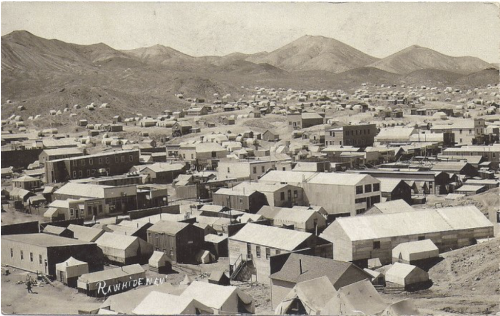
Town of Rawhide, NV Circa 1910
(source: onlyinyourstate.com)
Note that the location of the Property in the vicinity of Rawhide Mine or other nearby mineral properties does not guarantee exploration success or that mineral resources or reserves will be delineated at Koegel Rawhide.
The Property contains a major alteration zone that runs north and northwest and has an approximate width of 600 feet and length of 5,000 feet. This alteration zone has been mapped and has been sampled with rock chip geochemistry. It hosts both bulk disseminated gold and silver mineralization, and also contains a zone of higher grade gold and silver mineralization called the T-10 High Grade Zone.
LOCATION & OWNERSHIP
The Property is located approximately 45 miles southeast of Fallon, NV and four miles south of the Rawhide Mine. It is also four miles south of two other properties owned by Emgold – Buckskin Rawhide East (leased to RMC) and Buckskin Rawhide West.
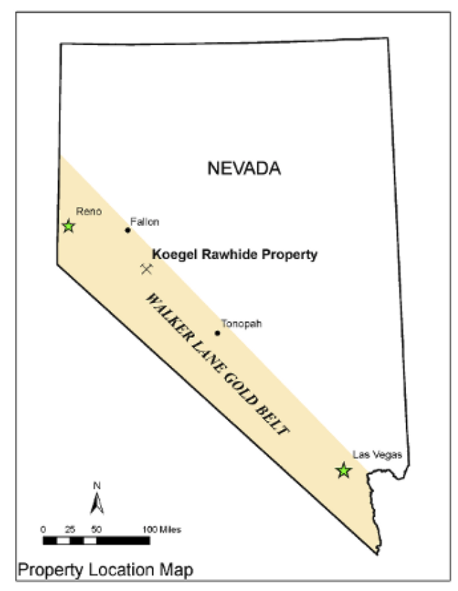
Koegel Rawhide Property
Location Map
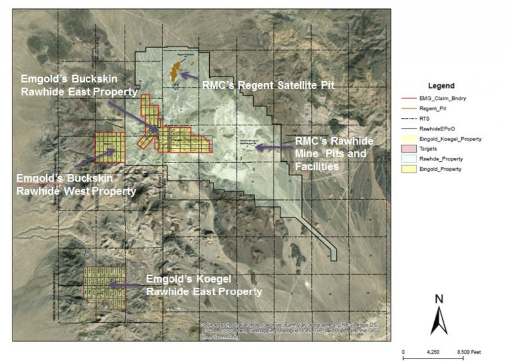
Koegel Rawhide Property
(Location South of Rawhide Mine and Other Emgold Properties)
Emgold originally optioned the Koegel Rawhide Property from Jeremy Wire under a lease and option to purchase agreement (see February 13, 2012 news release). At that time, the Property consisted of 19 unpatented mineral lode claims totaling 380 acres. Shortly thereafter, Emgold staked 17 unpatented mining claims, totaling 340 acres (see February 5, 2012 press release).
Emgold made advance royalty payments of US$140,000 from 2012 and 2018 and exercised its option to acquire the Property. Jeremy Wire retains a 2% Net Smelter Royalty (“NSR”) on the Property that Emgold has the option of acquiring for US$1.0 million, less any advance royalty payments already made.
GEOLOGY & MINERALIZATION
The Property is a volcanic-hosted, structurally controlled, epithermal gold-silver target situated in the Walker Lane gold belt of western Nevada. The Walker Lane is a regional shear zone and known gold trend that has hosted large and small historic and recent gold-silver mines in western Nevada, including mines of the Comstock Lode, Tonopah District and Rawhide District. From 1981 through 2009, mines located in Mineral County that were situated in the Walker Lane gold trend produced 2,800,448 ounces of gold and 56,112,442 ounces of silver (Muntean, 2010).
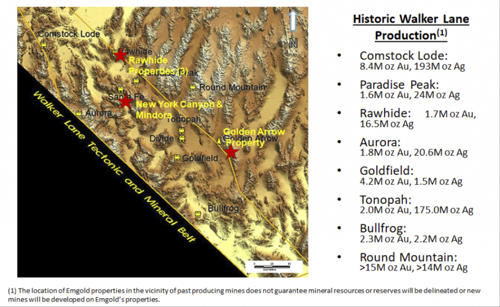
Emgold Properties and Historic
Walker Lane Gold Production
Property geology and mineralization is similar to the nearby Rawhide Mine, and Emergent's Buckskin Rawhide East Property. Mineralization is associated with structures from the Walker Lane and the Basin and Range along with lithologic units and structures of the Rawhide volcanic center.
Charles P. Watson, geologist, mapped the area in the early 1990’s and described the lithologic units as being late Tertiary age felsic to intermediate volcanics, including andesitic tuff flows and tuff flow breccias, that were intruded by numerous dikes and sills. These rocks were subsequently folded into a broad anticline. Faulting then took place, with the dominant orientation being west-northwest, and with west, and northeast-trending cross faults. Dominant hydrothermal alteration (silicification and argillic) occurs along the west-northwest trending structures. Watson felt that multiple generations of fault movement and hydrothermal alteration had occurred.
Watson identified a major alteration zone on the Property that runs north and northwest called the T-10 Alteration Zone. It is approximately 600 feet in width and 5,000 feet in length. Within this alteration zone, the T-10 High Grade Zone was identified from historic sampling and confirmed by Emgold sampling.
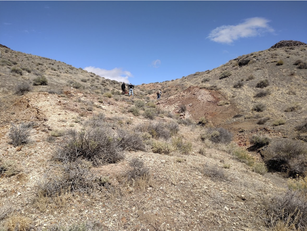
Koegel Rawhide Property
Alteration Zone Looking North
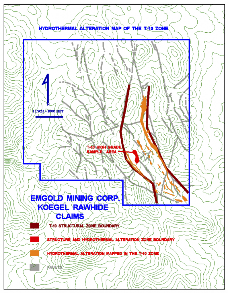
Koegel Rawhide Property
Alteration Zone and T-10 High Grade Vein Zone
EXPLORATION
Gold was originally discovered on the Buckskin Rawhide claims in the year 1906. A gold rush in the area led to a number of mining claims being staked, ultimately forming the Regent Mining District (now known as the Rawhide Mining District). The gold rush led to the formation of the town of Rawhide, which grew to a population of 7,000 by 1908, falling back to 500 by the year 1910. By the 1940’s, the town was essentially abandoned.
The Rawhide District was active with mining from 1908-1920, during which time 46,218 fine ounces of gold and 685,901 fine ounces of silver were produced from the historic mines. From 1921 through 1935, only 2,815 fine ounces of gold and 51,463 fine ounces of silver were produced from the Rawhide Mining District (Vanderburg, 1937).
There is also evidence of historic exploration activity on the Koegel Rawhide Property. Shallow historic prospects are present. However, information on the extent of these workings is unknown at this time.
Modern exploration in the Rawhide area appears to have begun in the 1980’s, most of which was done by Kennecott Exploration Company. At that time, Kennecott was exploring the entire Rawhide District, eventually discovering and developing the Rawhide Mine, which Kennecott Minerals Company and others have operated from 1988 to present.
Modern exploration of the Koegel Rawhide Property began in 1991 when property owner Jeremy Wire commissioned Charles P. Watson, a consulting geologist, to conduct geologic mapping, rock sampling, and geochemical interpretation of the Property. A detailed geologic map was produced and 221 surface rock samples were taken from the RHT claim group and assayed for gold and other pathfinder elements. A separate investigation was completed by Watson on the GEL claims in 1992, and 207 samples were taken. The results of this work defined the T-10 High Grade Zone, which is part of the T-Trend vein system that has a strike length of 5,000 feet and a width of 600 feet. Other structures were also identified that are potential exploration targets.
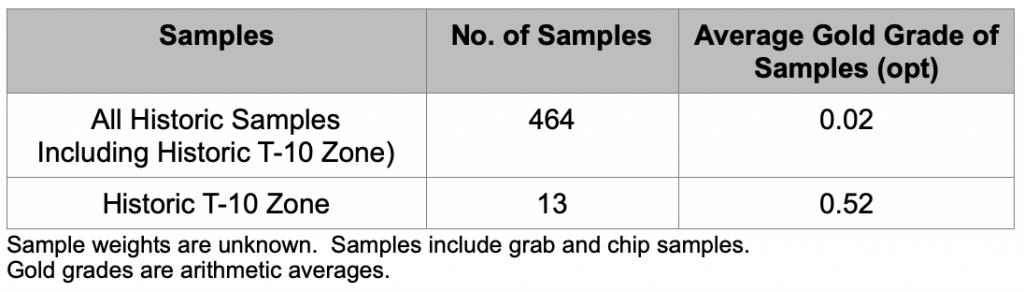
The results of the historic sampling on the Property ranged from non-detectable to 1.99 ounce per ton gold, with 98 percent of those samples having gold grades less than 0.10 ounces per ton gold and two percent being greater than 0.10 ounces per ton gold. The average gold grade of all historic samples is shown in Table 1, below:
Table 1
Average Grades of Historic Gold Assays
Koegel Rawhide Property, NV
In 2011, Emergent's geologists performed rock chip sampling of the Property, and confirmed the presence of high grade mineralization along the T-10 High Grade Zone (see news release dated February 27, 2012). Fourteen samples were taken. This work was part of Emergent's due diligence investigation of the Property prior to acquisition.
Dimensions of the T-10 High Grade Zone have not yet been defined (i.e. it is open for expansion in several directions and true width is unknown). Exposures sampled to date have a width of approximately eight feet.
Ten rock chip-channel samples, each 12 inches in length, and four grab samples were taken from outcrops of bedrock and structures. The average gold grade of all samples is shown in Table 2. Dry sample weights varied from one to two pounds.
Table 2
Average Grades of Emgold Gold Assays
Koegel Rawhide Property, NV
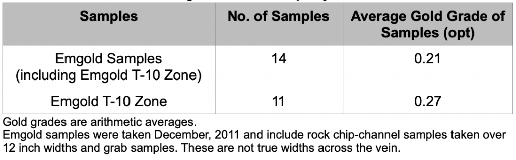
Emergent's sampling results from all 14 samples ranged from non-detectable to 1.60 ounces per ton gold, with 79 percent of the samples having gold grades less than 0.10 ounce per ton gold. Twenty-one percent had grades greater than 0.10 ounce per ton gold. Note that the average grade of Emergent's 14 gold assays, as shown in Table 2, is higher than the average grade from the 464 samples historically assayed on the Property, and shown in Table 1. This is because most of Emergent's samples were taken from known higher grade mineralized structures and did not evaluate bulk disseminated targets.
The grade of the 11 samples taken in the T-10 High Grade Zone ranged between non-detectable and 1.60 ounce per ton gold. The average grade was 0.27 opt gold. Results of Emergent's sampling compared favorably with historic sampling on the Property.
Historic samples were taken prior to the implementation of NI 43-101 and CIM Standards for Disclosure, therefore quality assurance and quality control measures are unknown. They have not been verified by Emergent's geologist. However, the historic sampling does compare with modern sampling done by Emgold.
Emgold’s quality assurance program and quality control measures at Koegel Rawhide used for its sampling program included representative sampling, proper numbering, and accurately locating samples in the field both visually on maps and also with a GPS instrument. Samples were transported by the geological staff from the field to Emgold’s office-warehouse facility to assure secure storage, and were then packaged for shipment to the assay laboratory. Samples were shipped by Emgold employees or via commercial carriers directly to the assay laboratory for analysis.
Emergent's Qualified Person Mr. Robert Pease, Chief Geologist of the Company, visited the assay laboratory to review the general sample handling and preparation measures, to make sure they were adequate. The assay laboratory catalogued all samples, maintained complete chain of custody throughout the analytical process, and electronically mailed the chain of custody forms to Emgold for review prior to initiating sample preparation. All sample preparation was done at the laboratory by their staff. As part of their quality assurance, the laboratory incorporated assaying standards, test blanks, and duplicate analyses of samples, and included those results in final reports. The final signed reports complete the chain of custody process. Thus far, no factors have been encountered in sampling programs conducted by Emgold on the Koegel Rawhide Property that would materially affect the accuracy or reliability of Emergent's sample data or cause loss of confidence in the laboratory. American Assay Laboratories, Inc. of Sparks, Nevada, an independent and adequately certified laboratory, conducted the laboratory analyses of Emergent's samples. Samples taken by Emgold were analyzed using standard fire assaying and ICP methods.
TECHNICAL REPORT
No Technical Report has yet been completed for the Property.
QUALIFICATIONS
Mr. Robert Pease, CPG, acting as the Qualified Person for Emgold, has reviewed and approved the information on this webpage.
REFERENCES
Muntean, J. L., 2010, Major Precious-Metal Deposits, in the Nevada Mineral Industry 2009: Nevada Bureau of Mines and Geology Special Publication MI-2009.
Nevada Bureau of Mines and Geology Special Publications (multiple years used to obtain Rawhide Mine production data).
Vanderburg, W. O., 1937, Reconnaissance of Mining Districts in Mineral County, Nev.: Dept. of the Interior United States Bureau of Mines Information Circular 6941.
DISCLAIMER
Readers are cautioned to review the Disclaimer Page on this website for qualifications that may be applicable to the information contained on this Property Page, including forward looking statements, definitions of mineral resources and reserves, etc. Readers are also cautions to review Emergent's financial statements and management’s discussion and analysis available on this website or at www.sedar.com for additional information.
PROPERTY OVERVIEW
|
LOCATION |
45 mi southeast of Fallon, NV |
|
TYPE OF PROJECT |
Early stage exploration |
|
NUMBER OF CLAIMS |
36 unpatented claims |
|
PROPERTY SIZE |
720 ac. |
|
OWNERSHIP |
100% owned by Emgold |
|
PROPERTY STATUS |
Available for sale or option |
|
UNDERLYING ROYALTIES |
2% NSR, which can be purchased for US$1 million, less any advance royalties paid |
|
EXPLORATION COMPLETED |
|
|
KEY EXPLORATION TARGETS |
|
|
NI 43-101 TECHNICAL REPORT |
None completed to date |
|
MINERAL RESOURCES |
None defined to date |
|
EXPLORATION HIGHLIGHTS |
|
INTRODUCTION
The Koegel Rawhide Property (“Koegel Rawhide” or the “Property”) is an early stage gold and silver exploration property located in the Walker Lane Gold Belt in the Rawhide Mining District, Mineral County, Nevada. It is located four miles south of Rawhide Mining LLC’s operating Rawhide Mine (aka Denton Rawhide Mine).
Gold was originally discovered at Rawhide, NV in 1906. In the 1980’s, Kennecott Exploration Company consolidated a large land package and, in 1988, Kennecott Minerals Company developed the Rawhide Mine. As of 2018, the latest available public data, Rawhide Mine has produced 1.7 million ounces of gold and 16.5 million ounces of silver (Nevada Bureau of Mines).
Town of Rawhide, NV Circa 1910
(source: onlyinyourstate.com)
Note that the location of the Property in the vicinity of Rawhide Mine or other nearby mineral properties does not guarantee exploration success or that mineral resources or reserves will be delineated at Koegel Rawhide.
The Property contains a major alteration zone that runs north and northwest and has an approximate width of 600 feet and length of 5,000 feet. This alteration zone has been mapped and has been sampled with rock chip geochemistry. It hosts both bulk disseminated gold and silver mineralization, and also contains a zone of higher grade gold and silver mineralization called the T-10 High Grade Zone.
LOCATION & OWNERSHIP
The Property is located approximately 45 miles southeast of Fallon, NV and four miles south of the Rawhide Mine. It is also four miles south of two other properties owned by Emgold – Buckskin Rawhide East (leased to RMC) and Buckskin Rawhide West.
Koegel Rawhide Property
Location Map
Koegel Rawhide Property
(Location South of Rawhide Mine and Other Emgold Properties)
Emgold originally optioned the Koegel Rawhide Property from Jeremy Wire under a lease and option to purchase agreement (see February 13, 2012 news release). At that time, the Property consisted of 19 unpatented mineral lode claims totaling 380 acres. Shortly thereafter, Emgold staked 17 unpatented mining claims, totaling 340 acres (see February 5, 2012 press release).
Emgold made advance royalty payments of US$140,000 from 2012 and 2018 and exercised its option to acquire the Property. Jeremy Wire retains a 2% Net Smelter Royalty (“NSR”) on the Property that Emgold has the option of acquiring for US$1.0 million, less any advance royalty payments already made.
GEOLOGY & MINERALIZATION
The Property is a volcanic-hosted, structurally controlled, epithermal gold-silver target situated in the Walker Lane gold belt of western Nevada. The Walker Lane is a regional shear zone and known gold trend that has hosted large and small historic and recent gold-silver mines in western Nevada, including mines of the Comstock Lode, Tonopah District and Rawhide District. From 1981 through 2009, mines located in Mineral County that were situated in the Walker Lane gold trend produced 2,800,448 ounces of gold and 56,112,442 ounces of silver (Muntean, 2010).
Emgold Properties and Historic
Walker Lane Gold Production
Property geology and mineralization is similar to the nearby Rawhide Mine, and Emergent's Buckskin Rawhide East Property. Mineralization is associated with structures from the Walker Lane and the Basin and Range along with lithologic units and structures of the Rawhide volcanic center.
Charles P. Watson, geologist, mapped the area in the early 1990’s and described the lithologic units as being late Tertiary age felsic to intermediate volcanics, including andesitic tuff flows and tuff flow breccias, that were intruded by numerous dikes and sills. These rocks were subsequently folded into a broad anticline. Faulting then took place, with the dominant orientation being west-northwest, and with west, and northeast-trending cross faults. Dominant hydrothermal alteration (silicification and argillic) occurs along the west-northwest trending structures. Watson felt that multiple generations of fault movement and hydrothermal alteration had occurred.
Watson identified a major alteration zone on the Property that runs north and northwest called the T-10 Alteration Zone. It is approximately 600 feet in width and 5,000 feet in length. Within this alteration zone, the T-10 High Grade Zone was identified from historic sampling and confirmed by Emgold sampling.
Koegel Rawhide Property
Alteration Zone Looking North
Koegel Rawhide Property
Alteration Zone and T-10 High Grade Vein Zone
EXPLORATION
Gold was originally discovered on the Buckskin Rawhide claims in the year 1906. A gold rush in the area led to a number of mining claims being staked, ultimately forming the Regent Mining District (now known as the Rawhide Mining District). The gold rush led to the formation of the town of Rawhide, which grew to a population of 7,000 by 1908, falling back to 500 by the year 1910. By the 1940’s, the town was essentially abandoned.
The Rawhide District was active with mining from 1908-1920, during which time 46,218 fine ounces of gold and 685,901 fine ounces of silver were produced from the historic mines. From 1921 through 1935, only 2,815 fine ounces of gold and 51,463 fine ounces of silver were produced from the Rawhide Mining District (Vanderburg, 1937).
There is also evidence of historic exploration activity on the Koegel Rawhide Property. Shallow historic prospects are present. However, information on the extent of these workings is unknown at this time.
Modern exploration in the Rawhide area appears to have begun in the 1980’s, most of which was done by Kennecott Exploration Company. At that time, Kennecott was exploring the entire Rawhide District, eventually discovering and developing the Rawhide Mine, which Kennecott Minerals Company and others have operated from 1988 to present.
Modern exploration of the Koegel Rawhide Property began in 1991 when property owner Jeremy Wire commissioned Charles P. Watson, a consulting geologist, to conduct geologic mapping, rock sampling, and geochemical interpretation of the Property. A detailed geologic map was produced and 221 surface rock samples were taken from the RHT claim group and assayed for gold and other pathfinder elements. A separate investigation was completed by Watson on the GEL claims in 1992, and 207 samples were taken. The results of this work defined the T-10 High Grade Zone, which is part of the T-Trend vein system that has a strike length of 5,000 feet and a width of 600 feet. Other structures were also identified that are potential exploration targets.
The results of the historic sampling on the Property ranged from non-detectable to 1.99 ounce per ton gold, with 98 percent of those samples having gold grades less than 0.10 ounces per ton gold and two percent being greater than 0.10 ounces per ton gold. The average gold grade of all historic samples is shown in Table 1, below:
Table 1
Average Grades of Historic Gold Assays
Koegel Rawhide Property, NV
In 2011, Emergent's geologists performed rock chip sampling of the Property, and confirmed the presence of high grade mineralization along the T-10 High Grade Zone (see news release dated February 27, 2012). Fourteen samples were taken. This work was part of Emergent's due diligence investigation of the Property prior to acquisition.
Dimensions of the T-10 High Grade Zone have not yet been defined (i.e. it is open for expansion in several directions and true width is unknown). Exposures sampled to date have a width of approximately eight feet.
Ten rock chip-channel samples, each 12 inches in length, and four grab samples were taken from outcrops of bedrock and structures. The average gold grade of all samples is shown in Table 2. Dry sample weights varied from one to two pounds.
Table 2
Average Grades of Emgold Gold Assays
Koegel Rawhide Property, NV
Emergent's sampling results from all 14 samples ranged from non-detectable to 1.60 ounces per ton gold, with 79 percent of the samples having gold grades less than 0.10 ounce per ton gold. Twenty-one percent had grades greater than 0.10 ounce per ton gold. Note that the average grade of Emergent's 14 gold assays, as shown in Table 2, is higher than the average grade from the 464 samples historically assayed on the Property, and shown in Table 1. This is because most of Emergent's samples were taken from known higher grade mineralized structures and did not evaluate bulk disseminated targets.
The grade of the 11 samples taken in the T-10 High Grade Zone ranged between non-detectable and 1.60 ounce per ton gold. The average grade was 0.27 opt gold. Results of Emergent's sampling compared favorably with historic sampling on the Property.
Historic samples were taken prior to the implementation of NI 43-101 and CIM Standards for Disclosure, therefore quality assurance and quality control measures are unknown. They have not been verified by Emergent's geologist. However, the historic sampling does compare with modern sampling done by Emgold.
Emgold’s quality assurance program and quality control measures at Koegel Rawhide used for its sampling program included representative sampling, proper numbering, and accurately locating samples in the field both visually on maps and also with a GPS instrument. Samples were transported by the geological staff from the field to Emgold’s office-warehouse facility to assure secure storage, and were then packaged for shipment to the assay laboratory. Samples were shipped by Emgold employees or via commercial carriers directly to the assay laboratory for analysis.
Emergent's Qualified Person Mr. Robert Pease, Chief Geologist of the Company, visited the assay laboratory to review the general sample handling and preparation measures, to make sure they were adequate. The assay laboratory catalogued all samples, maintained complete chain of custody throughout the analytical process, and electronically mailed the chain of custody forms to Emgold for review prior to initiating sample preparation. All sample preparation was done at the laboratory by their staff. As part of their quality assurance, the laboratory incorporated assaying standards, test blanks, and duplicate analyses of samples, and included those results in final reports. The final signed reports complete the chain of custody process. Thus far, no factors have been encountered in sampling programs conducted by Emgold on the Koegel Rawhide Property that would materially affect the accuracy or reliability of Emergent's sample data or cause loss of confidence in the laboratory. American Assay Laboratories, Inc. of Sparks, Nevada, an independent and adequately certified laboratory, conducted the laboratory analyses of Emergent's samples. Samples taken by Emgold were analyzed using standard fire assaying and ICP methods.
TECHNICAL REPORT
No Technical Report has yet been completed for the Property.
QUALIFICATIONS
Mr. Robert Pease, CPG, acting as the Qualified Person for Emgold, has reviewed and approved the information on this webpage.
REFERENCES
Muntean, J. L., 2010, Major Precious-Metal Deposits, in the Nevada Mineral Industry 2009: Nevada Bureau of Mines and Geology Special Publication MI-2009.
Nevada Bureau of Mines and Geology Special Publications (multiple years used to obtain Rawhide Mine production data).
Vanderburg, W. O., 1937, Reconnaissance of Mining Districts in Mineral County, Nev.: Dept. of the Interior United States Bureau of Mines Information Circular 6941.
DISCLAIMER
Readers are cautioned to review the Disclaimer Page on this website for qualifications that may be applicable to the information contained on this Property Page, including forward looking statements, definitions of mineral resources and reserves, etc. Readers are also cautions to review Emergent's financial statements and management’s discussion and analysis available on this website or at www.sedar.com for additional information.