PROPERTY OVERVIEW
| LOCATION | 40 miles east of Tonopah, NV |
| TYPE OF PROJECT | Early stage exploration |
| NUMBER OF CLAIMS | 511 patented and unpatented claims |
| PROPERTY SIZE | 10,000 ac |
| EMERGENT OWNERSHIP | 100% (17 patented claims owned, 309 unpatented claims owned, 185 unpatented claims leased) |
| UNDERLYING ROYALTIES |
|
| EXPLORATION COMPLETED |
|
| KEY EXPLORATION TARGET | Gold Coin, Hidden Hill, and Page Fault |
| TECHNICAL REPORT | Amended 2018 Updated Technical Report on the Golden Arrow Project, Nye County, Nevada, U.S.A., Ristorcelli, Christensen, and McPartland, Report Date September 24, 2018, Effective Date August 28, 2018 |
| RESOURCES | M&I – 12.2M tons at 0.024 opt Au and 0.33 opt silver containing 296,500 oz. Au and 4.0M oz. Ag
I – 2.8 M tons at 0.013 opt Au and 0.33 opt Ag containing 50,400 oz. Au and 1.2M oz. Ag |
| HIGHLIGHTS | Project with a significant Measured and Indicated gold equivalent resource and an Environmental Assessment and Plan of Operations in place to allow a major drill program with the goal of increasing the resource size to 0.5M t0 1 M which would have potential to support an open pit heap leach operation |
INTRODUCTION
On October 5, 2018, Emgold announced it had acquired a 100% interest in the Golden Arrow Property, NV (“Golden Arrow” or the “Property”),rom Nevada Sunrise Gold Corporation (TSXV: NEV). The Property is an early stage gold and silver exploration property located about 40 miles east of Tonopah. It consists of 357 contiguous unpatented lode mineral claims and 17 patented lode mineral claims covering about 7,050 acres, including the historic Golden Arrow Mining District.
Golden Arrow has a Canadian Institute of Mining compliant measured and indicated resource of 12.2 million tons with an average gold grade of 0.028 ounces per ton (opt) totaling 296,500 ounces and an average silver grade of 0.33 opt totaling 4.0 million ounces (see details below). Two main resource areas have been drilled to date – Gold Coin and Hidden Hill. Potential exists for expansion of these resources in the vicinity of known resource areas and by exploration of other targets on the Property.
Drilling to date exceeds 201,000 feet from 361 reverse circulation and diamond core holes. The property comes with an extensive exploration database including geologic mapping, geochemical sampling, and geophysics. Potential exists for both bulk disseminated mineralization and high grade vein mineralization. The deposit has similar geologic characteristics to the Rawhide Mine and Emergent's other Nevada properties in the vicinity of Rawhide Mine.
On May 11, 2016, Nevada Sunrise obtained approval of a Plan of Operations (the “Plan”) and an Environmental Assessment (the “EA”) for the Golden Arrow Property from the U.S. Bureau of Land Management (the “BLM”). The Plan and EA contemplate approximately 240,000 feet of drilling of an estimated 240 holes to explore for new areas of gold mineralization on 1,500 acres of the property and to potentially expand the known gold resources. Having the Plan and EA already in place will allow Emgold to move forward with a major drilling program at Golden Arrow, subject to funding.
On September 27, 2018 Emgold filed the “Amended 2018 Updated Technical Report on the Golden Arrow Project, Nye, County, Nevada, USA, prepared for Emgold Mining Corporation and Nevada Sunrise Gold Corporation by Mine Development Associates, Reno, Nevada (“MDA”). The Authors or the report recommend a two-phased approach to advance the Property, with the goal of completing a Preliminary Economic Assessment (“PEA”) by the end of Phase 2. They recommend Phase 1 include a comprehensive review of presently available technical data to define potential drilling targets for discovery of new mineral centers and identify locations for drilling within the current resource areas to upgrade mineral resources from Inferred to Indicated classification. Following a review of the technical data, preparation of a new geological map for the project area is recommended for clarification of district volcanic stratigraphy, as well as preparation of several geological cross sections based upon the mapping and drilling information. Rock-chip and soil geochemistry will complement the geological mapping. The proposed budget for Phase 1 recommended work is US$150,000.
Following the completion of Phase 1, a decision would be made whether or how to proceed with Phase 2. Phase 2 would include drilling and metallurgical test work followed by a scoping study and potentially a PEA, depending on the scoping study results. The budget for Phase 2 could potentially range from $1,000,000 to $3,000,000. Exploration drilling is presently warranted even without Phase 1, but Phase 1 will be used to design the drill program for Phase 2.
On January 12, 2021, Emgold announced it has staked an additional 137 unpatented claims at Golden Arrow. This increased the size of the property to 17 patented claims and 494 unpatented claims. The size of the Property is currently about 10,000 acres.
LOCATION & OWNERSHIP
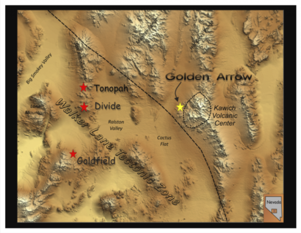
Golden Arrow is located about 40 miles east of Tonopah, NV. Emgold has a 100% interest in the Property, subject to underlying lease royalty agreements. The Property consists of 494 unpatented and 17 patented load mineral claims covering an area of approximately 10,000 acres (4,000 hectares).
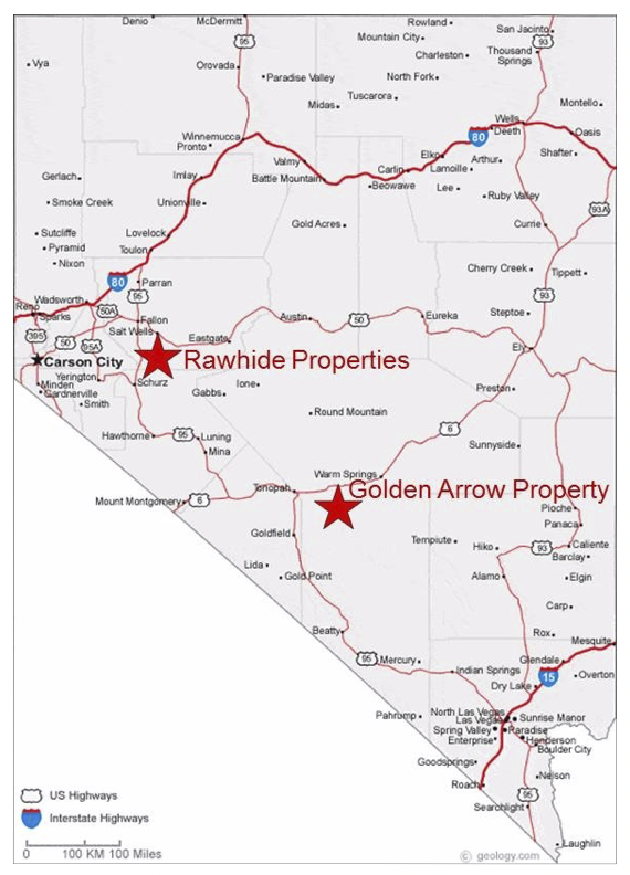
Golden Arrow Property, NV
Location Map
The 17 patented mining claims are subject to a 1% NSR. The royalty is payable to Mary Kane et al. (6 claims) after smelting costs and operating costs. The royalty is payable to Nevada Agricultural Foundation (11 claims) after smelting and transportation costs only.
Six unpatented mineral lode claims are subject to a 3% NSR royalty to Pomroy Neighbors et al. Emgold retains the right to purchase up to 2% of this royalty interest for US$100,000 per percentage point. Emgold makes US$25,000 per year advance royalty payments to Pomroy Neighbors et al., which credit toward production royalty payments.
Several claim blocks, totaling 185 unpatented lode claims are held through a lease controlled by Maverix Metals Inc. (a royalty company). Emgold is required to make Advance Royalty Payments to Maverix Metals Inc. of US$25,000 per year. Emgold may purchase 1% of the royalty for US$1.0 million and any time.
Golden Arrow Mining District
Circa 1920
GEOLOGY & MINERALIZATION
Golden Arrow is situated along the northeastern margin of the Walker Lane structural zone and along the western margin of the Kawich volcanic caldera. Walker Lane is a zone of complicated geological formations including complex faulting, igneous intrusion, volcanism, and hydrothermal mineralization resulting from the North American continent colliding with the Pacific tectonic plate. This has created the formation of a great variety of gold, silver and other mineral deposits. The Walker Lane has past production and defined resources of more than 30 million ounces of gold and 400 million ounces of silver. Notable districts include the Comstock Lode, the historic Tonopah and Goldfield districts, and Round Mountain, one of the most significant gold mines in Nevada.
Walker Lane
Historic Production
Bedrock geology is characterized by a thick sequence of volcanic rocks ranging in composition from andesite to rhyolite and including the complex geological formations typical of caldera margin settings: flows, flow-domes, tuffs, lithic tuff breccias, ignimbrites, graben-filling units, lithologic wedges and volcaniclastic maar sediments. In the immediate deposit area, the oldest rocks are andesite flows and volcaniclastic rocks. These were intruded by a cluster of rhyolite flow-domes and a large alaskite stock, and are overlain by rhyolite ash-flow tuffs and ignimbrite.
Gold and silver mineralization at Golden Arrow includes mineral zones typical of both low-sulfidation quartz-adularia veins and high-sulfidation hot-spring type mineralization related to the Kawich caldera. Historic production was realized from discrete high-grade ore shoots within larger fault-controlled quartz-adularia-gold veins in andesite of the volcanic basement. More recent exploration has mainly focused upon definition of large-tonnage disseminated mineralization, with the discovery and delineation of two centers of mineralization – the Gold Coin and Hidden Hill deposits.
The Gold Coin deposit outcrops and extends northwestward from the Confidence Mountain rhyolite flow dome. The Hidden Hill deposit, located approximately 1,000 feet northwest from Gold Coin, is largely hosted in silicified rhyolite-arkose maar sediments deposited in a basin extending away from the rhyolite center. Much of the higher grade mineralization is spatially associated with pepperite breccia at the margin of latite dikes. Both high grade vein and bulk disseminated mineralization can be found on the Property.
Golden Arrow Deposit
in Relation to the
Kawich Caldera and Walker Lane
Golden Arrow Deposit
High Grade Vein Mineralization
(vein approximately 4 feet in width)
Golden Arrow Deposit
Bulk Disseminated Mineralization
(Gold Coin Deposit, Confidence Mountain
The figure below shows a plan view of Golden Arrow and the location of the Gold Coin and Hidden Hill deposits. These are both hot springs style bulk disseminated deposits associated with the Kawich caldera to the east. Historic mineralization was associated with northwest trending Walker Lane faults and northeast trending Basin and Range faults. Many of the historic underground workings are found along the Page Fault.
Golden Arrow Deposit
Plan View Showing Known Deposits, Geology, and Structural Controls
The following figure shows a conceptual cross section of the Golden Arrow deposit showing the hot springs mineralization and also mineralization associated with faults and shear zones (which co-exist in some cases).
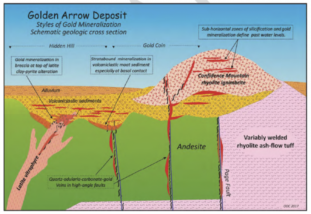
Golden Arrow Deposit
Conceptual Geologic Cross Section
Showing Styles of Mineralization
A variety of exploration targets at Golden Arrow and priorities are shown in the figure below. Exploration targets include expanding existing resource areas, the Page Fault and other potentially parallel northeast trending faults and structures, northwest trending faults and structures associated with the Walker Lane, and targets identified by geophysics.
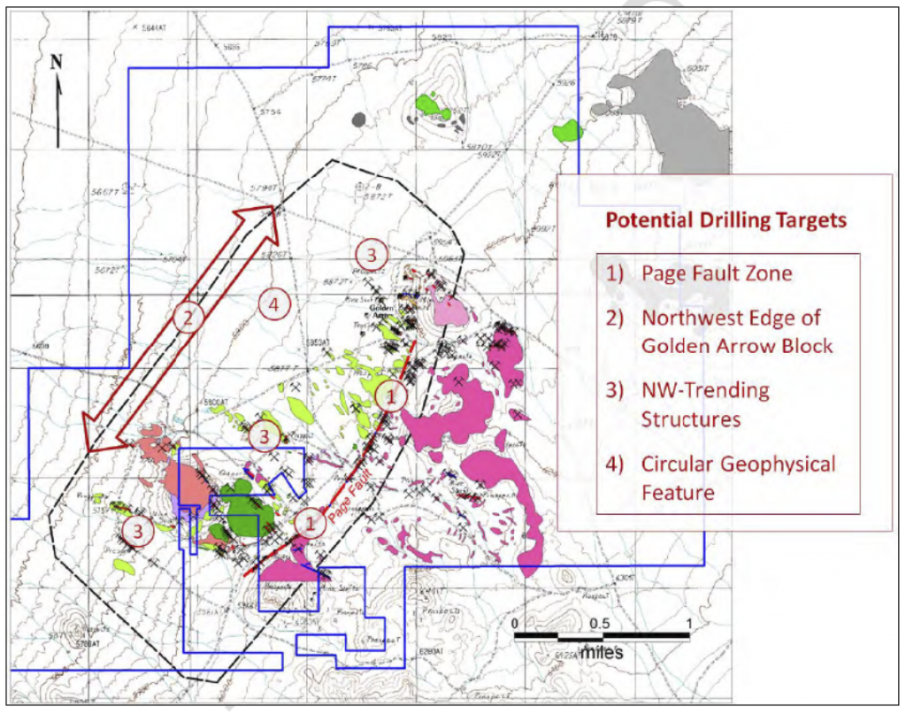
Golden Arrow Deposit
Exploration Targets
A link to a paper titled Exploration Geology of the Golden Arrow Gold-Silver District, Nye County, Nevada written by Odin Christensen and presented at the 2010 Geologic Society of Nevada 2010 Symposium is below.
EXPLORATION
High-grade gold-quartz veins were discovered at Golden Arrow in 1905 and mined from 1917 through the 1930’s from numerous shafts to about 500 feet in depth (to the water table). Historic production was from veins and tabular breccia bodies with ore occurring in lenses and shoots. A link to a paper written by H.G. Ferguson on the Golden Arrow, Clifford, and Ellendale Districts, Nye County Nevada, USGS Bulletin 640-F, 1916 is below outlines historic mining activities in the Golden Arrow District.
Exploration and Geology of the Golden Arrow Gold Silver District
Golden Arrow has been subject to a succession of exploration programs and companies since 1981. B.M. Clem and Golden American Joint Venture explored the property from 1981 to 1984. They drilled 24 rotary holes totaling 4,130 feet to a depth of 200 feet. They conducted column-leach tests of waste dump samples from historic underground mining activities, did minor geological mapping, and took 254 rock chip samples. No records of this exploration activity have been located.
From 1984 to 1985, Vector Exploration Inc. (subsequently Vector International Inc.) and Hydromet Ltd. Joint Venture completed backhoe trenching (4,200 feet), dozer scrapes (1,500 feet), and geochemical sampling (600 samples). They drilled 19 hammer holes from 8 to 28 feet in depth. No records of this exploration activity have been located.
In 1986 and 1987, Clogau Gold Mines (also described as Clogau Ltd. and Clogau (Nevada) Inc.) conducted aerial photography, produced orthophoto and topographic maps, conducted district scale geological mapping, and drilled 89 air-track holes totalling 4,540 feet. No records of this exploration activity have been located.
The Property was explored by a number of companies in subsequent years. Much of the exploration data from this exploration work has been located. In total, data from more than 361 drill holes exceeding 201,000 feet in total has been located, plus numerous geochemical and geophysical surveys. Exploration work led to the discovery of the Gold Coin deposit on Confidence Mountain and the Hidden Hill deposit northeast of Gold Coin. Numerous other exploration targets have been identified. A summary of exploration work done by the various companies is shown in the table below.
|
Golden Arrow Property |
||
|
Company |
Year |
Work Completed |
| Homestake |
1988 |
|
| Westgold |
1989-90 |
|
| Independence |
1991-92 |
|
| Coeur |
1994-94 |
|
| Kennecott |
1996 |
|
| Tombstone |
1997 |
|
| Bonanza Exploration |
2000-01 |
|
| Nevada Sunrise LLC |
2003 |
|
| Pacific Ridge |
2003-04 |
|
| Nevada Sunrise Gold Corporation |
2005-08 |
|
| Animas |
2009 |
|
| Nevada Sunrise Gold Corporation |
2010-17 |
|
| Emgold Mining Corporation |
2018-present |
|
A historical archive of drilling data was assembled by Nevada Sunrise that includes drill core and cuttings. It contains technical data for 361 drill holes – 342 reverse-circulation percussion holes and 19 diamond core holes. All of the available core and cuttings were re-logged in a consistent format by Nevada Sunrise geologists.
|
Golden Arrow Property |
|||||||||
|
Company |
Year |
Number of RC Holes |
RC Footage |
Number of Core Holes |
Core Footage |
Total Holes |
Total Footage |
||
| Homestake |
1988 |
38 |
16,580 |
0 |
0 |
38 |
16,580.0 |
||
| Westgold |
1989-90 |
81 |
36,206 |
6 |
3,599 |
87 |
39,805 |
||
| Independence |
1992 |
13 |
6,795 |
0 |
0 |
13 |
6,795 |
||
| Coeur |
1993-94 |
25 |
17,153 |
4 |
3,007 |
29 |
20,160 |
||
| Kennecott |
1996 |
8 |
5,570 |
0 |
0 |
8 |
5,570 |
||
| Tombstone |
1997 |
86 |
40,150 |
0 |
0 |
86 |
40,150 |
||
| Pacific Ridge |
2003-04 |
30 |
19,041 |
0 |
0 |
30 |
19,041 |
||
| Nevada Surnise Gold Corp. |
2008 |
28 |
16,880 |
5 |
3,584 |
33 |
20,464 |
||
| Animas Resources |
2009 |
12 |
10,400 |
4 |
3,785 |
16 |
14,185 |
||
| Nevada Sunrise Gold Corp. |
2012 |
Nevada Sunrise Gold Corp. |
2012 |
21 |
18,265 |
0 |
0 |
21 |
18,265 |
| Total |
342 |
187,040 |
19 |
13,975 |
361 |
201,014 |
|||
The table below is a summary of selected significant intercepts from drilling with gold equivalent intercepts greater than or equal to 0.01 opt gold equivalent grade and with lengths greater than or equal to 100 feet. Higher grade intercepts with grades greater than or equal to 0.1 opt gold equivalent are highlighted in grey in the table. Lengths do not represent true widths. A gold to silver ratio of 70:1 was used to calculate the significant intercepts with no adjustment for metallurgical recovery. GC represents holes in the Gold Coin resource area and HH represents holes in the Hidden Hill Resource area.
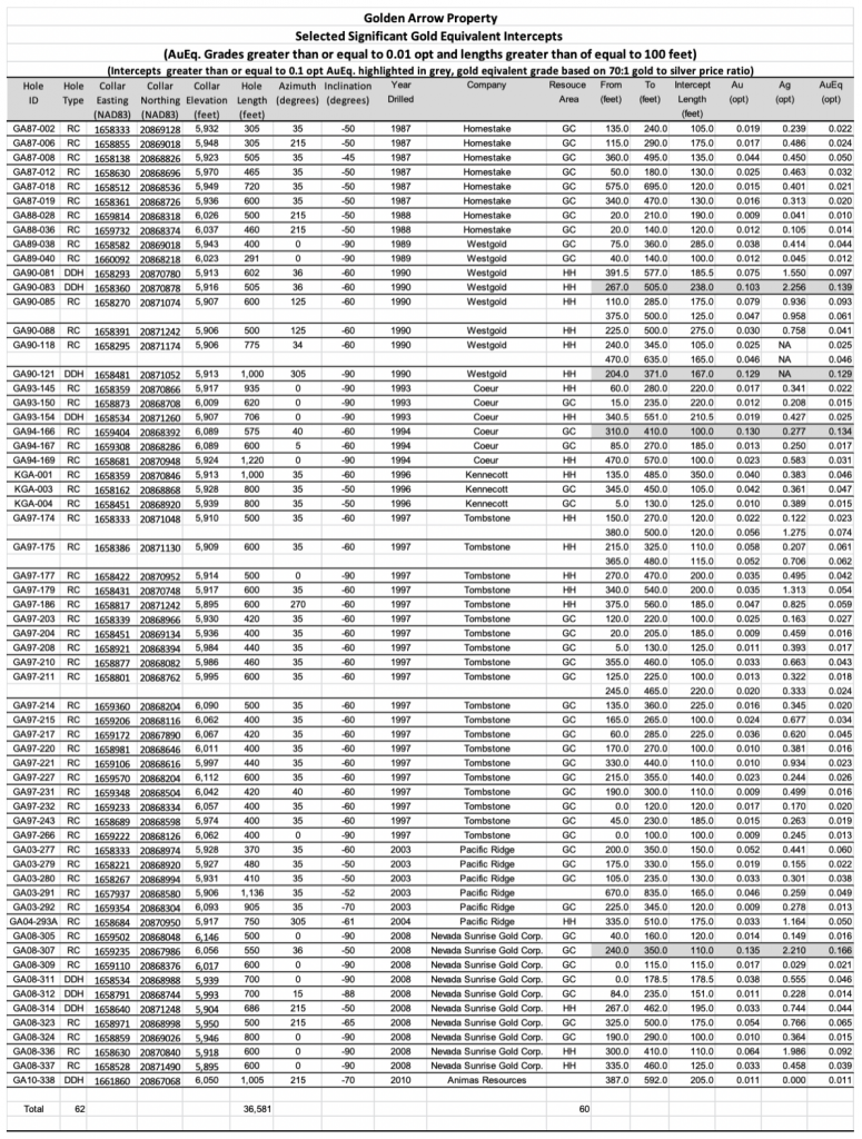
A link to a table showing all significant drill results with gold equivalent grades greater than 0.01 opt gold equivalent is shown below. Lengths are not true widths. A 70:1 gold to silver ratio is used to calculate gold equivalent grades.
Table of significant Drill Intercepts
The table below is a summary of selected significant intercepts from drilling with gold equivalent intercepts greater than or equal to 0.075 opt gold equivalent grade and with lengths greater than or equal to 15 feet. Lengths do not represent true widths. A gold to silver ratio of 70:1 was used to calculate the significant intercepts with no adjustment of metallurgical recovery. GC represents holes in the Gold Coin resource area and HH represents holes in the Hidden Hill Resource area.
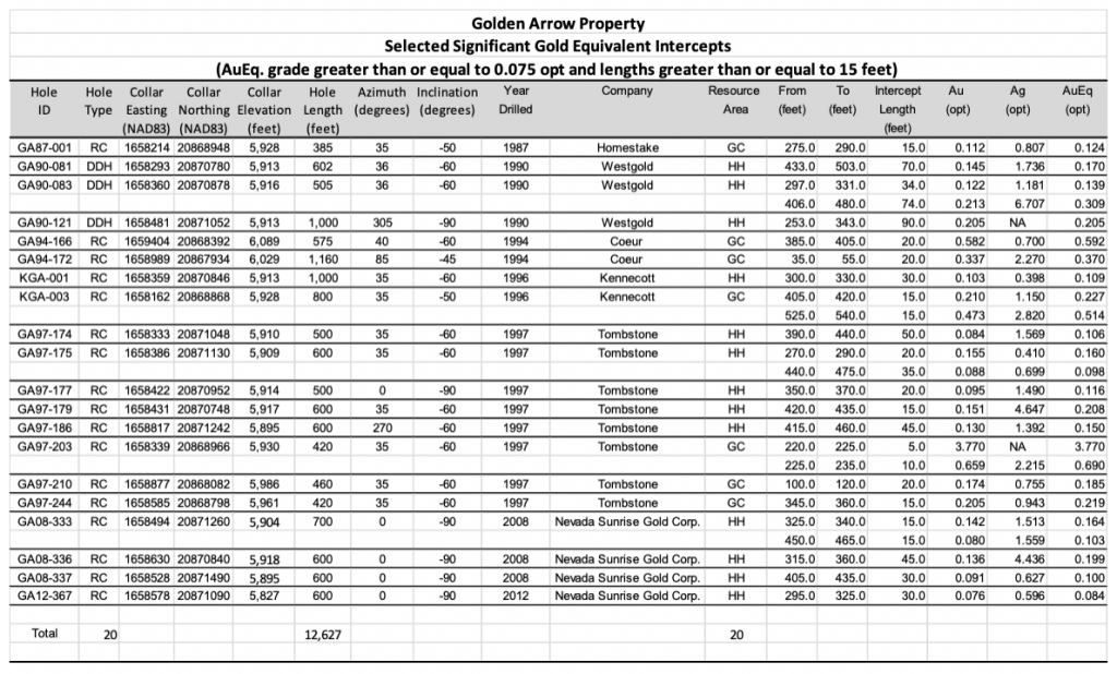
A link to a table showing all significant drill results with gold equivalent grades greater than 0.075 opt gold equivalent is shown below. Lengths are not true widths. A 70:1 gold to silver ratio is used to calculate gold equivalent grades.
Significant Gold Equivalent Intercepts
These tables illustrate the potential for bulk disseminated mineralization that may be recoverable by open pit mining methods (subject to permitting, economic studies, and other factors). They also illustrate the potential of higher grade vein mineralization that may be recoverable by either open pit or underground mining methods (subject to permitting, economic studies, and other factors.
Nevada Sunrise went through a considerable effort to assure the integrity of the historic drill hole database including re-surveying of hole collars and re-logging of drill core and chip samples. They were also able to obtain the original assay reports for much of the historic drilling. Note that historic work prior to 2001 was done before to the adoption of NI 43-101 and standards for drilling and assaying being adopted by the mining industry.
Modern work done by Nevada Sunrise was done under a QA/QC program which included representative sampling, proper numbering, and accurately locating sample locations in the field. Field duplicates, internal duplicates, pulp duplicates, insertion of blanks, use of gold standards where incorporated into the program. All samples were kept secure. Drill core and cuttings were processed by American Assay Labs in Sparks< NV. Checks were done by ALS Chemex in Reno, NV. Both are independent and adequately certified laboratories.
Past exploration has included several programs of rock-chip and soil geochemistry. Rock chip geochemistry has defined high concentrations of gold associated with the Confidence Mountain rhyolite flow-dome and extending 1 mile southward along the Page Fault system. The most extensive multi-element soil geochemical survey, completed in 2003, covered 8.5 square kilometers. Gold and pathfinder elements highlight the known deposits and point toward several exploration targets.
A considerable array of geophysical information has been collected on Golden Arrow over the years using various methods of measurement, including gravity, ground and aeromagnetic surveys, airborne EM, IP-resistivity, and radiometrics. The known deposits occur in distinct geologic settings, with discsernable geophysical signatures. New geophysical models define additional exploration targets for drill testing.
In 2011, Nevada Sunrise carried out Quantec Geoscience’s state-of-the-art Orion 3-D geophysical survey at Golden Arrow to search for other centers of mineralization. The Orion 3-D survey collects three sets of data in multi-directions – DC resistivity, IP (induced polarization) to depths of 2,500 feet, and deep MT (magnetotellurics) resistivity to depths greater than 6,000 feet. Interpretation of the Orion results led to follow-up drilling in 2012. Nevada Sunrise subsequently reinterpreted historic and modern geophysical studies in 2016, identifying a number of geophysical targets for follow up.
A total of four known metallurgical studies have been conducted on samples from Golden Arrow. Kennecott completed scoping-level metallurgical testing by analyzing a large suite of core and cuttings samples for gold and silver, both by fire assay and cyanide-extraction atomic absorption. Dawson Metallurgical Laboratories, Inc. conducted preliminary bottle-roll, cyanide leach tests on seven drill-hole composite samples in 1987. METCON Research Inc. completed 13 bottle-roll tests on five drill-hole composite samples in 1994. McClelland Laboratories, Inc. completed a more detailed metallurgical testing program initiated in 2008 by Nevada Sunrise on a total of 26 drill core composite samples. The McClelland Laboratories testing included bottle roll cyanidation tests on 23 samples, column leach cyanidation tests (five total) on three “master” composite samples, milling/cyanidation and milling/flotation tests on four high grade samples and gravity concentration tests on seven samples. Minerlized material at Golden Arrow can be characterized as oxide and unoxidized.
Results from cyanidation testing conducted at Dawson, METCON and McClelland Laboratories indicate that the Golden Arrow oxide material is amenable to cyanidation treatment, and that the Golden Arrow sulfide material tends to be more refractory to cyanidation treatment. Results from column testing conducted at McClelland Laboratories indicate that gold recoveries of 55% to 75% (65% recovery projected on average) can be expected by heap leaching of the Golden Arrow oxide material at a minus 13mm (½”) feed size. Reagent consumptions for heap leaching of the Golden Arrow oxide material are expected to be low to moderate.
Gold recovery from heap leaching of the sulfide material is expected to be lower, with existing test work indicating a 55% recovery.. Additional test work will be required prior to reserve definition to characterize the mineralized material and optimize gold and silver recovery.
There are no major environmental liabilities associated with the property. There are historic workings (shafts and adits) on the property and these have been fenced and signage posted. Exploration work has been done to date under Notices of Intent, which allow disturbance of less than 5 acres of land and require a reclamation bond.
In early 2015, Nevada Sunrise submitted a Plan of Operations (the “Plan”) for Golden Arrow to the BLM. The Plan contemplates approximately 73,000 metres (240,000 feet) of drilling in 240 holes to explore for areas of new gold mineralization at Golden Arrow, and to further refine the known gold resources. In support of the PLan, Nevada Sunrise completed biological surveys and a cultural survey in 2014 and in August 2015, an Environmental Assessment was filed by the Company. After a public review period, the Enviormental Assessment and Plan were approved by the BLM in May 2016.
A major advantage for Emgold in acquiring the Golden Arrow Property is that an Environmental Assessment assessment has been completed and a Plan of Operation is in place to allow Emgold to move forward with a significant exploration program. Emgold will be required to submit a reclamation bond prior to commencing this exploration work.
TECHNICAL REPORT
A Technical Report, entitled “Amended 2018 Updated Technical Report on the Golden Arrow Project, Nye County, Nevada, U.S.A.” was prepared for Emgold and Nevada Sunrise by Mine Development Associates in Reno, Nevada, and has an effective date of August 28, 2018 and a report date of September 24, 2018. The Technical Report was prepared by qualified persons Steven Ristorcelli, CPG, Odin D. Christensen, PhD, CPG, and Jack S. McPartland, MMSA (collectively, the “Authors”), in support of Emergent's first-time disclosure of a mineral resource for the Property. The Authors are independent of both Emgold, the issuer, and Nevada Sunrise, the vendor.
Ammended 2018 Technical Report
The Technical Report discloses a mineral resource, which particulars are set out in the table below. The mineral resource was modeled for the Property and estimated by evaluating the drill data statistically and utilizing a three‐dimensional geological solid model. Mineral domains were interpreted on northeast‐southwest geological cross sections spaced at approximately 100 foot intervals throughout the extent of the Property mineralization. The mineral domain interpretations were then rectified to east‐west cross sections spaced at 20 foot intervals. Estimation was done by inverse‐distance. The Authors were certified to make their own independent investigations based on what they deemed necessary, in their professional judgment, to be able to reasonably rely on the provided information to make the conclusions and recommendations presented in the Technical Report.
Golden Arrow Property
Mineral Resource1,2,3,7,8
|
Classification |
Cut-Off Grade4,5 |
Tons |
Au opt |
Ag opt |
Au Ounces |
Ag Ounces |
|
Measured |
Variable |
1,850,000 |
0.028 |
0.43 |
52,400 |
796,000 |
|
Indicated |
Variable |
10,322,000 |
0.024 |
0.31 |
244,100 |
3,212,000 |
|
Measured and Indicated |
Variable |
12,172,000 |
0.024 |
0.33 |
296,500 |
4,008,000 |
|
Inferred6 |
Variable |
3,790,000 |
0.013 |
0.33 |
50,400 |
1,249,000 |
- CIM Standards were followed in reporting the mineral resource estimate.
- Effective date of the mineral resource is November 28, 2017.
- Any known legal, political, environmental, or other risks that could materially affect the potential development of the Mineral Reserves are detailed below in the section entitled “Cautionary Note Regarding Forward-Looking Statements”.
- Cut-off grades are 0.01 gold equivalent opt for oxide material and 0.015 gold equivalent opt for sulfide material. Mine Development Associated derived these cut-off grades using mining costs of US$2.00 per ton, heap-leach costs of US$4.00 per ton, milling costs of US$12.00 per ton, and G&A costs of US$3.50 per ton. Metallurgical recoveries were assumed to range from 70% to 95% for gold, depending upon the oxidation state and sulfide content of the material, and heap-leach or milling scenarios envisioned. Multiple economic evaluations were done including pit optimization that demonstrated the economic viability.
- Gold equivalent cut-off grade calculated using a 55:1 gold to silver price ratio. No adjustment was made for metallurgical recovery.
- The quality and grade of inferred resources are uncertain in nature and there has been insufficient exploration to define these inferred resources as measured or indicated resources and it is uncertain whether further exploration will result in upgrading them to measured or indicated resource categories.
- Mineral resources that are not mineral reserves do not have demonstrated economic viability.
- The Authors verified the data in the Technical Report through a combination of data audits, where drilling data compiled in the project database was compared to paper logs, maps, assay certificates and other records, and independent verification sampling. There have been no limitations on, or failure to conduct the verification
As outlined in the Technical Report, the Authors have determined that the Golden Arrow Property is a property of merit that warrants continued exploration and recommend that Emgold undertake continued systematic exploration to discover additional centers of mineralization within the Property.
The Authors or the report recommend a two-phased approach to advance the Property, with the goal of completing a Preliminary Economic Assessment (“PEA”) by the end of Phase 2. They recommend Phase 1 include a comprehensive review of presently available technical data to define potential drilling targets for discovery of new mineral centers and identify locations for drilling within the current resource areas to upgrade mineral resources from Inferred to Indicated classification. Following a review of the technical data, preparation of a new geological map for the project area is recommended for clarification of district volcanic stratigraphy, as well as preparation of several geological cross sections based upon the mapping and drilling information. Rock-chip and soil geochemistry will complement the geological mapping. The proposed budget for Phase 1 recommended work is US$150,000.
Following the completion of Phase 1, a decision would be made whether or how to proceed with Phase 2. Phase 2 would include drilling and metallurgical test work followed by a scoping study and potentially a PEA, depending on the scoping study results. The budget for Phase 2 could potentially range from $1,000,000 to $3,000,000. Exploration drilling is presently warranted even without Phase 1, but Phase 1 will be used to design the drill program for Phase 2.
QUALIFICATIONS
Mr. Robert Pease, CPG, acting as the Qualified Person for Emgold, has reviewed and approved the information on this webpage.
REFERENCES
Christensen, O.D. Exploration Geology of the Golden Arrow Gold-Silver District, Nye County, Nevada 2010.
Ferguson, H.G., Golden Arrow, Clifford, and Ellendale Districts, Nye County Nevada, USGS Bulletin 640-F, 1916
Ristorcelli, S., and Christensen, O.D., 2008, Technical Report on Golden Arrow Project, Nye County, Nevada: Technical Report prepared for Nevada Sunrise Gold Corporation and filed on SEDAR,.
Ristorcelli, S., and Christensen, O.D., 2009, Updated Technical Report on Golden Arrow Project, Nye County, Nevada: Technical Report prepared for Nevada Sunrise Gold Corporation and filed on SEDAR.
Ristorcelli, S., and Christensen, O.D., 2010, Updated Technical Report on Golden Arrow Project, Nye County, Nevada: Technical Report prepared for Animas Resource Corporation and filed on SEDAR.
Ristorcelli, S., Christensen, O.D., and McPartland, J, 2018 Updated Technical Report on the Golden Arrow Project, Nye County, Nevada: Technical Report prepared for Emgold Mining Corporation and Nevada Sunrise Gold Corporation and filed on SEDAR.
Ristorcelli, S., Christensen, O.D., and McPartland, J, Amended 2018 Updated Technical Report on the Golden Arrow Project, Nye County, Nevada: Technical Report prepared for Emgold Mining Corporation and Nevada Sunrise Gold Corporation and filed on SEDAR.
DISCLAIMER
Readers are cautioned to review the Disclaimer Page on this website for qualifications that may be applicable to the information contained on this Property Page, including forward looking statements, definitions of mineral resources and reserves, etc. Readers are also cautions to review Emergent's financial statements and management’s discussion and analysis available on this website or at www.sedar.com for additional information.
PROPERTY OVERVIEW
| LOCATION | 40 miles east of Tonopah, NV |
| TYPE OF PROJECT | Early stage exploration |
| NUMBER OF CLAIMS | 511 patented and unpatented claims |
| PROPERTY SIZE | 10,000 ac |
| EMERGENT OWNERSHIP | 100% (17 patented claims owned, 309 unpatented claims owned, 185 unpatented claims leased) |
| UNDERLYING ROYALTIES |
|
| EXPLORATION COMPLETED |
|
| KEY EXPLORATION TARGET | Gold Coin, Hidden Hill, and Page Fault |
| TECHNICAL REPORT | Amended 2018 Updated Technical Report on the Golden Arrow Project, Nye County, Nevada, U.S.A., Ristorcelli, Christensen, and McPartland, Report Date September 24, 2018, Effective Date August 28, 2018 |
| RESOURCES | M&I – 12.2M tons at 0.024 opt Au and 0.33 opt silver containing 296,500 oz. Au and 4.0M oz. Ag
I – 2.8 M tons at 0.013 opt Au and 0.33 opt Ag containing 50,400 oz. Au and 1.2M oz. Ag |
| HIGHLIGHTS | Project with a significant Measured and Indicated gold equivalent resource and an Environmental Assessment and Plan of Operations in place to allow a major drill program with the goal of increasing the resource size to 0.5M t0 1 M which would have potential to support an open pit heap leach operation |
INTRODUCTION
On October 5, 2018, Emgold announced it had acquired a 100% interest in the Golden Arrow Property, NV (“Golden Arrow” or the “Property”),rom Nevada Sunrise Gold Corporation (TSXV: NEV). The Property is an early stage gold and silver exploration property located about 40 miles east of Tonopah. It consists of 357 contiguous unpatented lode mineral claims and 17 patented lode mineral claims covering about 7,050 acres, including the historic Golden Arrow Mining District.
Golden Arrow has a Canadian Institute of Mining compliant measured and indicated resource of 12.2 million tons with an average gold grade of 0.028 ounces per ton (opt) totaling 296,500 ounces and an average silver grade of 0.33 opt totaling 4.0 million ounces (see details below). Two main resource areas have been drilled to date – Gold Coin and Hidden Hill. Potential exists for expansion of these resources in the vicinity of known resource areas and by exploration of other targets on the Property.
Drilling to date exceeds 201,000 feet from 361 reverse circulation and diamond core holes. The property comes with an extensive exploration database including geologic mapping, geochemical sampling, and geophysics. Potential exists for both bulk disseminated mineralization and high grade vein mineralization. The deposit has similar geologic characteristics to the Rawhide Mine and Emergent's other Nevada properties in the vicinity of Rawhide Mine.
On May 11, 2016, Nevada Sunrise obtained approval of a Plan of Operations (the “Plan”) and an Environmental Assessment (the “EA”) for the Golden Arrow Property from the U.S. Bureau of Land Management (the “BLM”). The Plan and EA contemplate approximately 240,000 feet of drilling of an estimated 240 holes to explore for new areas of gold mineralization on 1,500 acres of the property and to potentially expand the known gold resources. Having the Plan and EA already in place will allow Emgold to move forward with a major drilling program at Golden Arrow, subject to funding.
On September 27, 2018 Emgold filed the “Amended 2018 Updated Technical Report on the Golden Arrow Project, Nye, County, Nevada, USA, prepared for Emgold Mining Corporation and Nevada Sunrise Gold Corporation by Mine Development Associates, Reno, Nevada (“MDA”). The Authors or the report recommend a two-phased approach to advance the Property, with the goal of completing a Preliminary Economic Assessment (“PEA”) by the end of Phase 2. They recommend Phase 1 include a comprehensive review of presently available technical data to define potential drilling targets for discovery of new mineral centers and identify locations for drilling within the current resource areas to upgrade mineral resources from Inferred to Indicated classification. Following a review of the technical data, preparation of a new geological map for the project area is recommended for clarification of district volcanic stratigraphy, as well as preparation of several geological cross sections based upon the mapping and drilling information. Rock-chip and soil geochemistry will complement the geological mapping. The proposed budget for Phase 1 recommended work is US$150,000.
Following the completion of Phase 1, a decision would be made whether or how to proceed with Phase 2. Phase 2 would include drilling and metallurgical test work followed by a scoping study and potentially a PEA, depending on the scoping study results. The budget for Phase 2 could potentially range from $1,000,000 to $3,000,000. Exploration drilling is presently warranted even without Phase 1, but Phase 1 will be used to design the drill program for Phase 2.
On January 12, 2021, Emgold announced it has staked an additional 137 unpatented claims at Golden Arrow. This increased the size of the property to 17 patented claims and 494 unpatented claims. The size of the Property is currently about 10,000 acres.
LOCATION & OWNERSHIP
Golden Arrow is located about 40 miles east of Tonopah, NV. Emgold has a 100% interest in the Property, subject to underlying lease royalty agreements. The Property consists of 494 unpatented and 17 patented load mineral claims covering an area of approximately 10,000 acres (4,000 hectares).
Golden Arrow Property, NV
Location Map
The 17 patented mining claims are subject to a 1% NSR. The royalty is payable to Mary Kane et al. (6 claims) after smelting costs and operating costs. The royalty is payable to Nevada Agricultural Foundation (11 claims) after smelting and transportation costs only.
Six unpatented mineral lode claims are subject to a 3% NSR royalty to Pomroy Neighbors et al. Emgold retains the right to purchase up to 2% of this royalty interest for US$100,000 per percentage point. Emgold makes US$25,000 per year advance royalty payments to Pomroy Neighbors et al., which credit toward production royalty payments.
Several claim blocks, totaling 185 unpatented lode claims are held through a lease controlled by Maverix Metals Inc. (a royalty company). Emgold is required to make Advance Royalty Payments to Maverix Metals Inc. of US$25,000 per year. Emgold may purchase 1% of the royalty for US$1.0 million and any time.
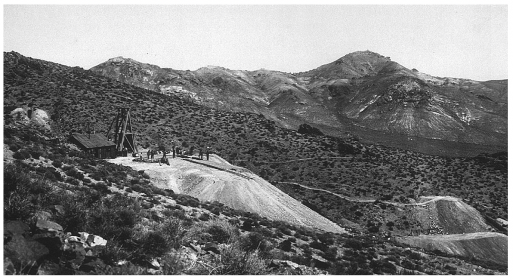
Golden Arrow Mining District
Circa 1920
GEOLOGY & MINERALIZATION
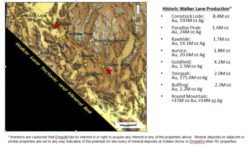
Golden Arrow is situated along the northeastern margin of the Walker Lane structural zone and along the western margin of the Kawich volcanic caldera. Walker Lane is a zone of complicated geological formations including complex faulting, igneous intrusion, volcanism, and hydrothermal mineralization resulting from the North American continent colliding with the Pacific tectonic plate. This has created the formation of a great variety of gold, silver and other mineral deposits. The Walker Lane has past production and defined resources of more than 30 million ounces of gold and 400 million ounces of silver. Notable districts include the Comstock Lode, the historic Tonopah and Goldfield districts, and Round Mountain, one of the most significant gold mines in Nevada.
Walker Lane
Historic Production
Bedrock geology is characterized by a thick sequence of volcanic rocks ranging in composition from andesite to rhyolite and including the complex geological formations typical of caldera margin settings: flows, flow-domes, tuffs, lithic tuff breccias, ignimbrites, graben-filling units, lithologic wedges and volcaniclastic maar sediments. In the immediate deposit area, the oldest rocks are andesite flows and volcaniclastic rocks. These were intruded by a cluster of rhyolite flow-domes and a large alaskite stock, and are overlain by rhyolite ash-flow tuffs and ignimbrite.
Gold and silver mineralization at Golden Arrow includes mineral zones typical of both low-sulfidation quartz-adularia veins and high-sulfidation hot-spring type mineralization related to the Kawich caldera. Historic production was realized from discrete high-grade ore shoots within larger fault-controlled quartz-adularia-gold veins in andesite of the volcanic basement. More recent exploration has mainly focused upon definition of large-tonnage disseminated mineralization, with the discovery and delineation of two centers of mineralization – the Gold Coin and Hidden Hill deposits.
The Gold Coin deposit outcrops and extends northwestward from the Confidence Mountain rhyolite flow dome. The Hidden Hill deposit, located approximately 1,000 feet northwest from Gold Coin, is largely hosted in silicified rhyolite-arkose maar sediments deposited in a basin extending away from the rhyolite center. Much of the higher grade mineralization is spatially associated with pepperite breccia at the margin of latite dikes. Both high grade vein and bulk disseminated mineralization can be found on the Property.
Golden Arrow Deposit
in Relation to the
Kawich Caldera and Walker Lane
Golden Arrow Deposit
High Grade Vein Mineralization
(vein approximately 4 feet in width)
Golden Arrow Deposit
Bulk Disseminated Mineralization
(Gold Coin Deposit, Confidence Mountain
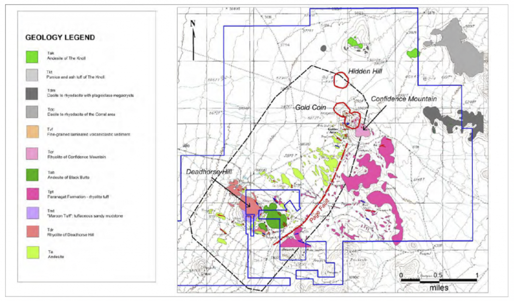
The figure below shows a plan view of Golden Arrow and the location of the Gold Coin and Hidden Hill deposits. These are both hot springs style bulk disseminated deposits associated with the Kawich caldera to the east. Historic mineralization was associated with northwest trending Walker Lane faults and northeast trending Basin and Range faults. Many of the historic underground workings are found along the Page Fault.
Golden Arrow Deposit
Plan View Showing Known Deposits, Geology, and Structural Controls
The following figure shows a conceptual cross section of the Golden Arrow deposit showing the hot springs mineralization and also mineralization associated with faults and shear zones (which co-exist in some cases).
Golden Arrow Deposit
Conceptual Geologic Cross Section
Showing Styles of Mineralization
A variety of exploration targets at Golden Arrow and priorities are shown in the figure below. Exploration targets include expanding existing resource areas, the Page Fault and other potentially parallel northeast trending faults and structures, northwest trending faults and structures associated with the Walker Lane, and targets identified by geophysics.
Golden Arrow Deposit
Exploration Targets
A link to a paper titled Exploration Geology of the Golden Arrow Gold-Silver District, Nye County, Nevada written by Odin Christensen and presented at the 2010 Geologic Society of Nevada 2010 Symposium is below.
EXPLORATION
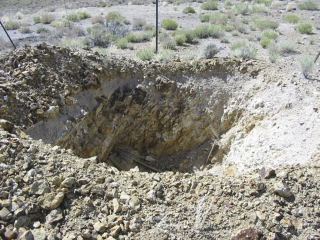
High-grade gold-quartz veins were discovered at Golden Arrow in 1905 and mined from 1917 through the 1930’s from numerous shafts to about 500 feet in depth (to the water table). Historic production was from veins and tabular breccia bodies with ore occurring in lenses and shoots. A link to a paper written by H.G. Ferguson on the Golden Arrow, Clifford, and Ellendale Districts, Nye County Nevada, USGS Bulletin 640-F, 1916 is below outlines historic mining activities in the Golden Arrow District.
Exploration and Geology of the Golden Arrow Gold Silver District
Golden Arrow has been subject to a succession of exploration programs and companies since 1981. B.M. Clem and Golden American Joint Venture explored the property from 1981 to 1984. They drilled 24 rotary holes totaling 4,130 feet to a depth of 200 feet. They conducted column-leach tests of waste dump samples from historic underground mining activities, did minor geological mapping, and took 254 rock chip samples. No records of this exploration activity have been located.
From 1984 to 1985, Vector Exploration Inc. (subsequently Vector International Inc.) and Hydromet Ltd. Joint Venture completed backhoe trenching (4,200 feet), dozer scrapes (1,500 feet), and geochemical sampling (600 samples). They drilled 19 hammer holes from 8 to 28 feet in depth. No records of this exploration activity have been located.
In 1986 and 1987, Clogau Gold Mines (also described as Clogau Ltd. and Clogau (Nevada) Inc.) conducted aerial photography, produced orthophoto and topographic maps, conducted district scale geological mapping, and drilled 89 air-track holes totalling 4,540 feet. No records of this exploration activity have been located.
The Property was explored by a number of companies in subsequent years. Much of the exploration data from this exploration work has been located. In total, data from more than 361 drill holes exceeding 201,000 feet in total has been located, plus numerous geochemical and geophysical surveys. Exploration work led to the discovery of the Gold Coin deposit on Confidence Mountain and the Hidden Hill deposit northeast of Gold Coin. Numerous other exploration targets have been identified. A summary of exploration work done by the various companies is shown in the table below.
|
Golden Arrow Property |
||
|
Company |
Year |
Work Completed |
| Homestake |
1988 |
|
| Westgold |
1989-90 |
|
| Independence |
1991-92 |
|
| Coeur |
1994-94 |
|
| Kennecott |
1996 |
|
| Tombstone |
1997 |
|
| Bonanza Exploration |
2000-01 |
|
| Nevada Sunrise LLC |
2003 |
|
| Pacific Ridge |
2003-04 |
|
| Nevada Sunrise Gold Corporation |
2005-08 |
|
| Animas |
2009 |
|
| Nevada Sunrise Gold Corporation |
2010-17 |
|
| Emgold Mining Corporation |
2018-present |
|
A historical archive of drilling data was assembled by Nevada Sunrise that includes drill core and cuttings. It contains technical data for 361 drill holes – 342 reverse-circulation percussion holes and 19 diamond core holes. All of the available core and cuttings were re-logged in a consistent format by Nevada Sunrise geologists.
|
Golden Arrow Property |
|||||||||
|
Company |
Year |
Number of RC Holes |
RC Footage |
Number of Core Holes |
Core Footage |
Total Holes |
Total Footage |
||
| Homestake |
1988 |
38 |
16,580 |
0 |
0 |
38 |
16,580.0 |
||
| Westgold |
1989-90 |
81 |
36,206 |
6 |
3,599 |
87 |
39,805 |
||
| Independence |
1992 |
13 |
6,795 |
0 |
0 |
13 |
6,795 |
||
| Coeur |
1993-94 |
25 |
17,153 |
4 |
3,007 |
29 |
20,160 |
||
| Kennecott |
1996 |
8 |
5,570 |
0 |
0 |
8 |
5,570 |
||
| Tombstone |
1997 |
86 |
40,150 |
0 |
0 |
86 |
40,150 |
||
| Pacific Ridge |
2003-04 |
30 |
19,041 |
0 |
0 |
30 |
19,041 |
||
| Nevada Surnise Gold Corp. |
2008 |
28 |
16,880 |
5 |
3,584 |
33 |
20,464 |
||
| Animas Resources |
2009 |
12 |
10,400 |
4 |
3,785 |
16 |
14,185 |
||
| Nevada Sunrise Gold Corp. |
2012 |
Nevada Sunrise Gold Corp. |
2012 |
21 |
18,265 |
0 |
0 |
21 |
18,265 |
| Total |
342 |
187,040 |
19 |
13,975 |
361 |
201,014 |
|||
The table below is a summary of selected significant intercepts from drilling with gold equivalent intercepts greater than or equal to 0.01 opt gold equivalent grade and with lengths greater than or equal to 100 feet. Higher grade intercepts with grades greater than or equal to 0.1 opt gold equivalent are highlighted in grey in the table. Lengths do not represent true widths. A gold to silver ratio of 70:1 was used to calculate the significant intercepts with no adjustment for metallurgical recovery. GC represents holes in the Gold Coin resource area and HH represents holes in the Hidden Hill Resource area.

A link to a table showing all significant drill results with gold equivalent grades greater than 0.01 opt gold equivalent is shown below. Lengths are not true widths. A 70:1 gold to silver ratio is used to calculate gold equivalent grades.
Table of significant Drill Intercepts
The table below is a summary of selected significant intercepts from drilling with gold equivalent intercepts greater than or equal to 0.075 opt gold equivalent grade and with lengths greater than or equal to 15 feet. Lengths do not represent true widths. A gold to silver ratio of 70:1 was used to calculate the significant intercepts with no adjustment of metallurgical recovery. GC represents holes in the Gold Coin resource area and HH represents holes in the Hidden Hill Resource area.
A link to a table showing all significant drill results with gold equivalent grades greater than 0.075 opt gold equivalent is shown below. Lengths are not true widths. A 70:1 gold to silver ratio is used to calculate gold equivalent grades.
Significant Gold Equivalent Intercepts
These tables illustrate the potential for bulk disseminated mineralization that may be recoverable by open pit mining methods (subject to permitting, economic studies, and other factors). They also illustrate the potential of higher grade vein mineralization that may be recoverable by either open pit or underground mining methods (subject to permitting, economic studies, and other factors.
Nevada Sunrise went through a considerable effort to assure the integrity of the historic drill hole database including re-surveying of hole collars and re-logging of drill core and chip samples. They were also able to obtain the original assay reports for much of the historic drilling. Note that historic work prior to 2001 was done before to the adoption of NI 43-101 and standards for drilling and assaying being adopted by the mining industry.
Modern work done by Nevada Sunrise was done under a QA/QC program which included representative sampling, proper numbering, and accurately locating sample locations in the field. Field duplicates, internal duplicates, pulp duplicates, insertion of blanks, use of gold standards where incorporated into the program. All samples were kept secure. Drill core and cuttings were processed by American Assay Labs in Sparks< NV. Checks were done by ALS Chemex in Reno, NV. Both are independent and adequately certified laboratories.
Past exploration has included several programs of rock-chip and soil geochemistry. Rock chip geochemistry has defined high concentrations of gold associated with the Confidence Mountain rhyolite flow-dome and extending 1 mile southward along the Page Fault system. The most extensive multi-element soil geochemical survey, completed in 2003, covered 8.5 square kilometers. Gold and pathfinder elements highlight the known deposits and point toward several exploration targets.
A considerable array of geophysical information has been collected on Golden Arrow over the years using various methods of measurement, including gravity, ground and aeromagnetic surveys, airborne EM, IP-resistivity, and radiometrics. The known deposits occur in distinct geologic settings, with discsernable geophysical signatures. New geophysical models define additional exploration targets for drill testing.
In 2011, Nevada Sunrise carried out Quantec Geoscience’s state-of-the-art Orion 3-D geophysical survey at Golden Arrow to search for other centers of mineralization. The Orion 3-D survey collects three sets of data in multi-directions – DC resistivity, IP (induced polarization) to depths of 2,500 feet, and deep MT (magnetotellurics) resistivity to depths greater than 6,000 feet. Interpretation of the Orion results led to follow-up drilling in 2012. Nevada Sunrise subsequently reinterpreted historic and modern geophysical studies in 2016, identifying a number of geophysical targets for follow up.
A total of four known metallurgical studies have been conducted on samples from Golden Arrow. Kennecott completed scoping-level metallurgical testing by analyzing a large suite of core and cuttings samples for gold and silver, both by fire assay and cyanide-extraction atomic absorption. Dawson Metallurgical Laboratories, Inc. conducted preliminary bottle-roll, cyanide leach tests on seven drill-hole composite samples in 1987. METCON Research Inc. completed 13 bottle-roll tests on five drill-hole composite samples in 1994. McClelland Laboratories, Inc. completed a more detailed metallurgical testing program initiated in 2008 by Nevada Sunrise on a total of 26 drill core composite samples. The McClelland Laboratories testing included bottle roll cyanidation tests on 23 samples, column leach cyanidation tests (five total) on three “master” composite samples, milling/cyanidation and milling/flotation tests on four high grade samples and gravity concentration tests on seven samples. Minerlized material at Golden Arrow can be characterized as oxide and unoxidized.
Results from cyanidation testing conducted at Dawson, METCON and McClelland Laboratories indicate that the Golden Arrow oxide material is amenable to cyanidation treatment, and that the Golden Arrow sulfide material tends to be more refractory to cyanidation treatment. Results from column testing conducted at McClelland Laboratories indicate that gold recoveries of 55% to 75% (65% recovery projected on average) can be expected by heap leaching of the Golden Arrow oxide material at a minus 13mm (½”) feed size. Reagent consumptions for heap leaching of the Golden Arrow oxide material are expected to be low to moderate.
Gold recovery from heap leaching of the sulfide material is expected to be lower, with existing test work indicating a 55% recovery.. Additional test work will be required prior to reserve definition to characterize the mineralized material and optimize gold and silver recovery.
There are no major environmental liabilities associated with the property. There are historic workings (shafts and adits) on the property and these have been fenced and signage posted. Exploration work has been done to date under Notices of Intent, which allow disturbance of less than 5 acres of land and require a reclamation bond.
In early 2015, Nevada Sunrise submitted a Plan of Operations (the “Plan”) for Golden Arrow to the BLM. The Plan contemplates approximately 73,000 metres (240,000 feet) of drilling in 240 holes to explore for areas of new gold mineralization at Golden Arrow, and to further refine the known gold resources. In support of the PLan, Nevada Sunrise completed biological surveys and a cultural survey in 2014 and in August 2015, an Environmental Assessment was filed by the Company. After a public review period, the Enviormental Assessment and Plan were approved by the BLM in May 2016.
A major advantage for Emgold in acquiring the Golden Arrow Property is that an Environmental Assessment assessment has been completed and a Plan of Operation is in place to allow Emgold to move forward with a significant exploration program. Emgold will be required to submit a reclamation bond prior to commencing this exploration work.
TECHNICAL REPORT
A Technical Report, entitled “Amended 2018 Updated Technical Report on the Golden Arrow Project, Nye County, Nevada, U.S.A.” was prepared for Emgold and Nevada Sunrise by Mine Development Associates in Reno, Nevada, and has an effective date of August 28, 2018 and a report date of September 24, 2018. The Technical Report was prepared by qualified persons Steven Ristorcelli, CPG, Odin D. Christensen, PhD, CPG, and Jack S. McPartland, MMSA (collectively, the “Authors”), in support of Emergent's first-time disclosure of a mineral resource for the Property. The Authors are independent of both Emgold, the issuer, and Nevada Sunrise, the vendor.
Ammended 2018 Technical Report
The Technical Report discloses a mineral resource, which particulars are set out in the table below. The mineral resource was modeled for the Property and estimated by evaluating the drill data statistically and utilizing a three‐dimensional geological solid model. Mineral domains were interpreted on northeast‐southwest geological cross sections spaced at approximately 100 foot intervals throughout the extent of the Property mineralization. The mineral domain interpretations were then rectified to east‐west cross sections spaced at 20 foot intervals. Estimation was done by inverse‐distance. The Authors were certified to make their own independent investigations based on what they deemed necessary, in their professional judgment, to be able to reasonably rely on the provided information to make the conclusions and recommendations presented in the Technical Report.
Golden Arrow Property
Mineral Resource1,2,3,7,8
|
Classification |
Cut-Off Grade4,5 |
Tons |
Au opt |
Ag opt |
Au Ounces |
Ag Ounces |
|
Measured |
Variable |
1,850,000 |
0.028 |
0.43 |
52,400 |
796,000 |
|
Indicated |
Variable |
10,322,000 |
0.024 |
0.31 |
244,100 |
3,212,000 |
|
Measured and Indicated |
Variable |
12,172,000 |
0.024 |
0.33 |
296,500 |
4,008,000 |
|
Inferred6 |
Variable |
3,790,000 |
0.013 |
0.33 |
50,400 |
1,249,000 |
- CIM Standards were followed in reporting the mineral resource estimate.
- Effective date of the mineral resource is November 28, 2017.
- Any known legal, political, environmental, or other risks that could materially affect the potential development of the Mineral Reserves are detailed below in the section entitled “Cautionary Note Regarding Forward-Looking Statements”.
- Cut-off grades are 0.01 gold equivalent opt for oxide material and 0.015 gold equivalent opt for sulfide material. Mine Development Associated derived these cut-off grades using mining costs of US$2.00 per ton, heap-leach costs of US$4.00 per ton, milling costs of US$12.00 per ton, and G&A costs of US$3.50 per ton. Metallurgical recoveries were assumed to range from 70% to 95% for gold, depending upon the oxidation state and sulfide content of the material, and heap-leach or milling scenarios envisioned. Multiple economic evaluations were done including pit optimization that demonstrated the economic viability.
- Gold equivalent cut-off grade calculated using a 55:1 gold to silver price ratio. No adjustment was made for metallurgical recovery.
- The quality and grade of inferred resources are uncertain in nature and there has been insufficient exploration to define these inferred resources as measured or indicated resources and it is uncertain whether further exploration will result in upgrading them to measured or indicated resource categories.
- Mineral resources that are not mineral reserves do not have demonstrated economic viability.
- The Authors verified the data in the Technical Report through a combination of data audits, where drilling data compiled in the project database was compared to paper logs, maps, assay certificates and other records, and independent verification sampling. There have been no limitations on, or failure to conduct the verification
As outlined in the Technical Report, the Authors have determined that the Golden Arrow Property is a property of merit that warrants continued exploration and recommend that Emgold undertake continued systematic exploration to discover additional centers of mineralization within the Property.
The Authors or the report recommend a two-phased approach to advance the Property, with the goal of completing a Preliminary Economic Assessment (“PEA”) by the end of Phase 2. They recommend Phase 1 include a comprehensive review of presently available technical data to define potential drilling targets for discovery of new mineral centers and identify locations for drilling within the current resource areas to upgrade mineral resources from Inferred to Indicated classification. Following a review of the technical data, preparation of a new geological map for the project area is recommended for clarification of district volcanic stratigraphy, as well as preparation of several geological cross sections based upon the mapping and drilling information. Rock-chip and soil geochemistry will complement the geological mapping. The proposed budget for Phase 1 recommended work is US$150,000.
Following the completion of Phase 1, a decision would be made whether or how to proceed with Phase 2. Phase 2 would include drilling and metallurgical test work followed by a scoping study and potentially a PEA, depending on the scoping study results. The budget for Phase 2 could potentially range from $1,000,000 to $3,000,000. Exploration drilling is presently warranted even without Phase 1, but Phase 1 will be used to design the drill program for Phase 2.
QUALIFICATIONS
Mr. Robert Pease, CPG, acting as the Qualified Person for Emgold, has reviewed and approved the information on this webpage.
REFERENCES
Christensen, O.D. Exploration Geology of the Golden Arrow Gold-Silver District, Nye County, Nevada 2010.
Ferguson, H.G., Golden Arrow, Clifford, and Ellendale Districts, Nye County Nevada, USGS Bulletin 640-F, 1916
Ristorcelli, S., and Christensen, O.D., 2008, Technical Report on Golden Arrow Project, Nye County, Nevada: Technical Report prepared for Nevada Sunrise Gold Corporation and filed on SEDAR,.
Ristorcelli, S., and Christensen, O.D., 2009, Updated Technical Report on Golden Arrow Project, Nye County, Nevada: Technical Report prepared for Nevada Sunrise Gold Corporation and filed on SEDAR.
Ristorcelli, S., and Christensen, O.D., 2010, Updated Technical Report on Golden Arrow Project, Nye County, Nevada: Technical Report prepared for Animas Resource Corporation and filed on SEDAR.
Ristorcelli, S., Christensen, O.D., and McPartland, J, 2018 Updated Technical Report on the Golden Arrow Project, Nye County, Nevada: Technical Report prepared for Emgold Mining Corporation and Nevada Sunrise Gold Corporation and filed on SEDAR.
Ristorcelli, S., Christensen, O.D., and McPartland, J, Amended 2018 Updated Technical Report on the Golden Arrow Project, Nye County, Nevada: Technical Report prepared for Emgold Mining Corporation and Nevada Sunrise Gold Corporation and filed on SEDAR.
DISCLAIMER
Readers are cautioned to review the Disclaimer Page on this website for qualifications that may be applicable to the information contained on this Property Page, including forward looking statements, definitions of mineral resources and reserves, etc. Readers are also cautions to review Emergent's financial statements and management’s discussion and analysis available on this website or at www.sedar.com for additional information.