| Location | British Columbia |
| Location Details | 7 km north of Salmo |
| Type of Project | Early stage exploration |
| Number of Claims | 28 mineral tenures |
| Est. Property Size | 5,789 ha |
| Emgold Ownership | 100% |
| Underlying Royalties | 3% NSR of which 2% can be purchased for C$1.0 million |
| Exploration Completed | · Soil and rock chip sampling
· Trenching · Geophysics · 102 diamond drill holes drilled totaling 13,737m from 1979 to present |
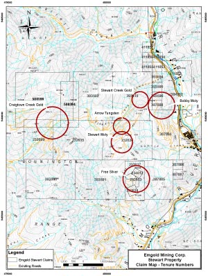
| Exploration Targets | Craigtown Creek Gold Zone, Stewart Creek Gold Zone, Free Silver Zone, Stewart Moly Zone, Bobbi Moly Zone, Arrow Tungsten Zone |
| Technical Report | None |
| Resources | None yet defined |
| Highlights | · Strategic property located south of and abuts the Kena Property, owned by Prize Mining Corporation. The Kena Property as a indicated resource of 24.9 million tonnes at an average grade of 0.60 grams per tonne gold containing 481,000 ounces of gold and a inferred resource of 85.8 million tonnes at an average grade of 0.48 grams per tonne gold containing 1,318,000 ounces of gold
· Property held until 2023 without additional work · Potential for a Cu/Mo porphyry system at depth |
The Stewart Property is an early stage poly-metalic property located in the Nelson Mining District of B.C. It is located in a region of historic mining activity and is part of a large north-south geologic trend containing occurrences of gold, silver, molybdenum, tungsten, copper, and other mineralization. Emgold and others have completed drilling on the Property intersecting gold, molybdenum, and tungsten mineralization. Six key exploration targets have been identified to date.
SUMMARY
Emgold Mining Corporation (“Emgold”) holds a 100 percent interest in the Stewart Property (“Stewart” or the “Property”) located directly west of the town of Ymir in southeastern British Columbia. The Property consists of 28 contiguous mineral tenures covering 5,789 hectares. The Property is located in the Ymir Camp of the Nelson Mining District of British Columbia.
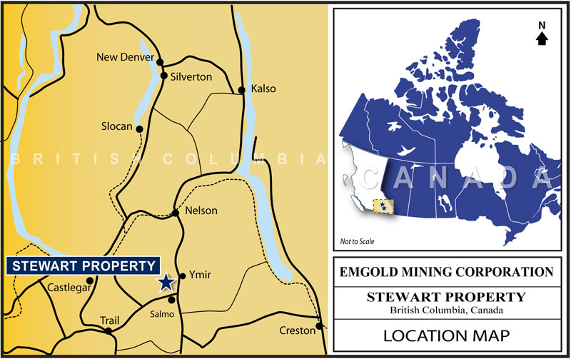
Stewart
Location Map
The Property is located south of and abuts the Kena Property, owned by Prize Mining Corporation. The Kena Property as a indicated resource of 24.9 million tonnes at an average grade of 0.60 grams per tonne gold containing 481,000 ounces of gold and a inferred resource of 85.8 million tonnes at an average grade of 0.48 grams per tonne gold containing 1,318,000 ounces of gold (source: Technical Report for the Kena Project, Nelson B.C., Giroux and Park, Report Date January 16, 2017, Effective Date January 7, 2017, Revised Date: June 2, 2017).
The Property is west of the Yankee Dundee Property which contains one of the largest historic gold and silver mines in the Ymir Camp. The B.C. Ministry of Energy, Mines, and Natural Gas data (available at www.minfile.gov.bc.ca) indicates the Yankee Girl Mine produced an estimated 371,000 tonnes of ore at an average recovered grade of 10.4 grams per tonne gold and 59.5 gram per tonne silver between 1907 and 1951. The Ymir Camp produced 883,000 tonne of ore at an average recovered grade of 12.67 grams per tonne gold and 60.23 grams per tonne silver between 1896 and 1980.
While the presence of historic gold and silver production on the Kena Property, Yankee Dundee Property and in the Ymir Camp does not imply similar results will be achieved at the Stewart Property, geologic mapping and geophysics does show similar geologic structures that overlap the Stewart Property and indicate the Property has good exploration potential for discovery of mineral resources.
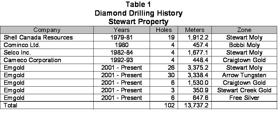
The Property contains a number of gold, silver, molybdenum, tungsten and silver-lead-zinc prospects that have been discovered by historic and recent exploration activity. The Property has been assessed by various operators since 1940’s exploring for various types of mineralization. A significant amount of historic data is available from those programs for use in guiding current exploration efforts. Table 1 shows historic and recent Emgold drilling on the Stewart Property, totaling 102 drill holes and 13,737.2 metres.
Exploration to date has included geological mapping, geochemical sampling, geophysics, trenching, and diamond drilling. This work has identified main six exploration targets to date. From the west side of the Property to the east, the targets include:
- Craigtown Creek Gold Zone;
- Stewart Creek Gold Zone;
- Free Silver Zone;
- Stewart Moly Zone;
- Bobbi Moly Zone; and
- Arrow Tungsten Zone.
These six targets comprise a complex zone of precious and base metal mineralization. In general, gold seems to be concentrated mostly on the northern side of the Property while silver and base metal occurrences are situated south of the gold areas in the center of the Property. Gold and rhenium have also been sampled in the Stewart Moly Zone as potential byproduct metals.
Stewart
View Looking South
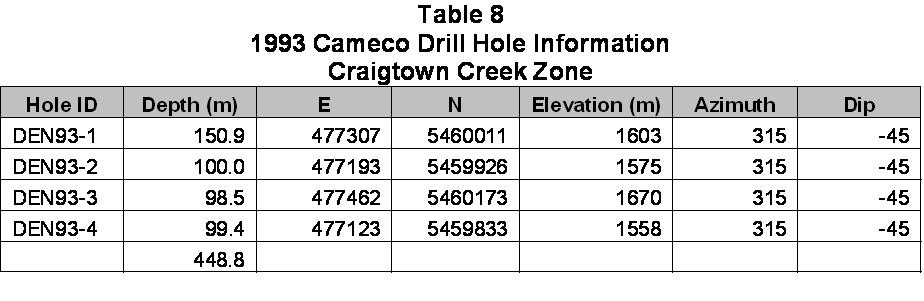
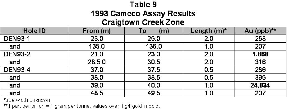
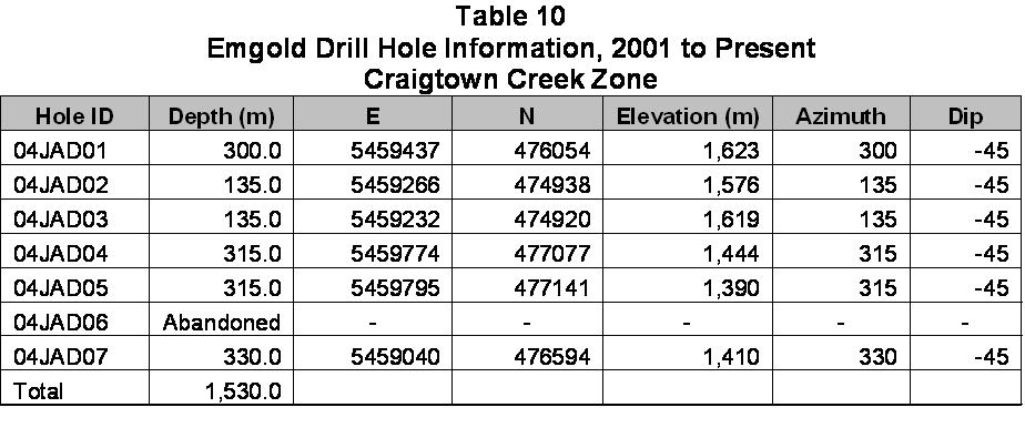
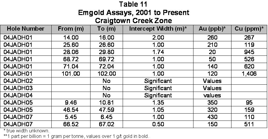
Craigtown Creek Gold Zone
The Craigtown Creek Gold Zone is located on the northwest side of the Property. Gold-bearing quartz veins were identified in historic drilling, and further explored by Emgold. Drilling to date in the Zone has included 10 diamond drill holes totaling 1,978.4 metres. Several intercepts returned elevated gold values greater than 1 gram per tonne gold.
Stewart Creek Gold Zone
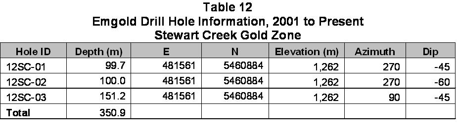
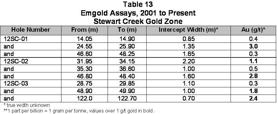
Located east of Craigtown Creek is the Stewart Creek Gold Zone. This exploration target was discovered by Emgold in 2012. Drilling to date to date has included three diamond drill holes totaling 350.9 metres. Several intercepts returned elevated gold values greater than 1 gram per tonne gold.
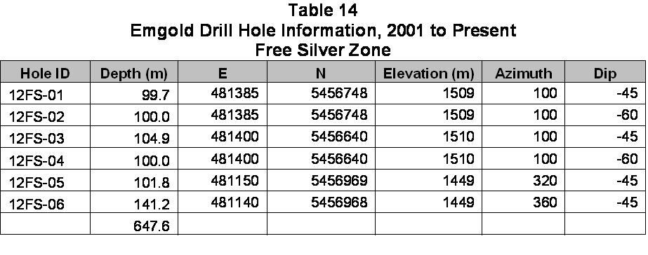
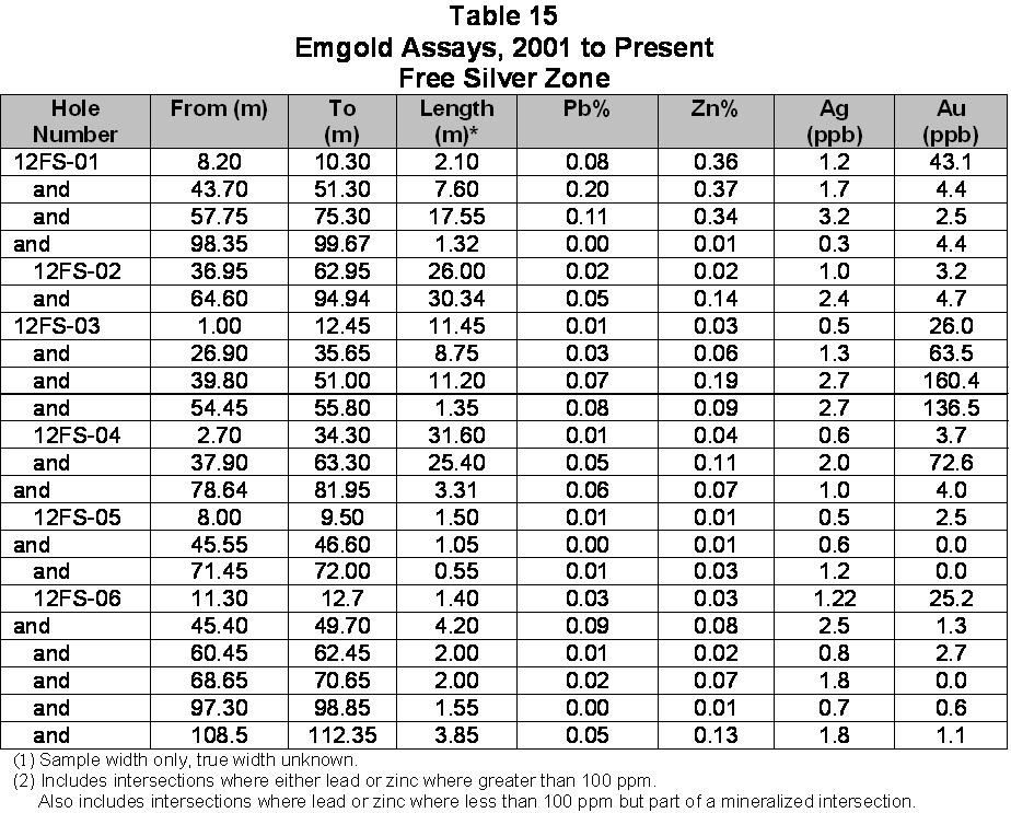
Free Silver Zone
The Free Silver Zone is a base metal target within a complex area of silver, lead, and zinc mineralization, located in the south-central part of the Stewart Property. Drilling to date has included 6 diamond drill holes totaling 647.6 meters. Several long, low grade lead and zinc intercepts were found in initial drilling completed in 2012.
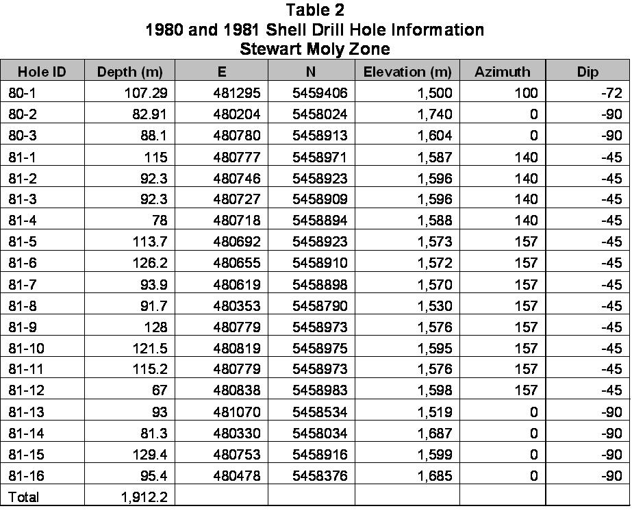
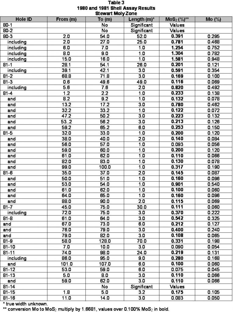
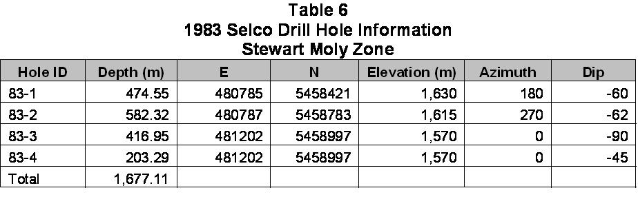
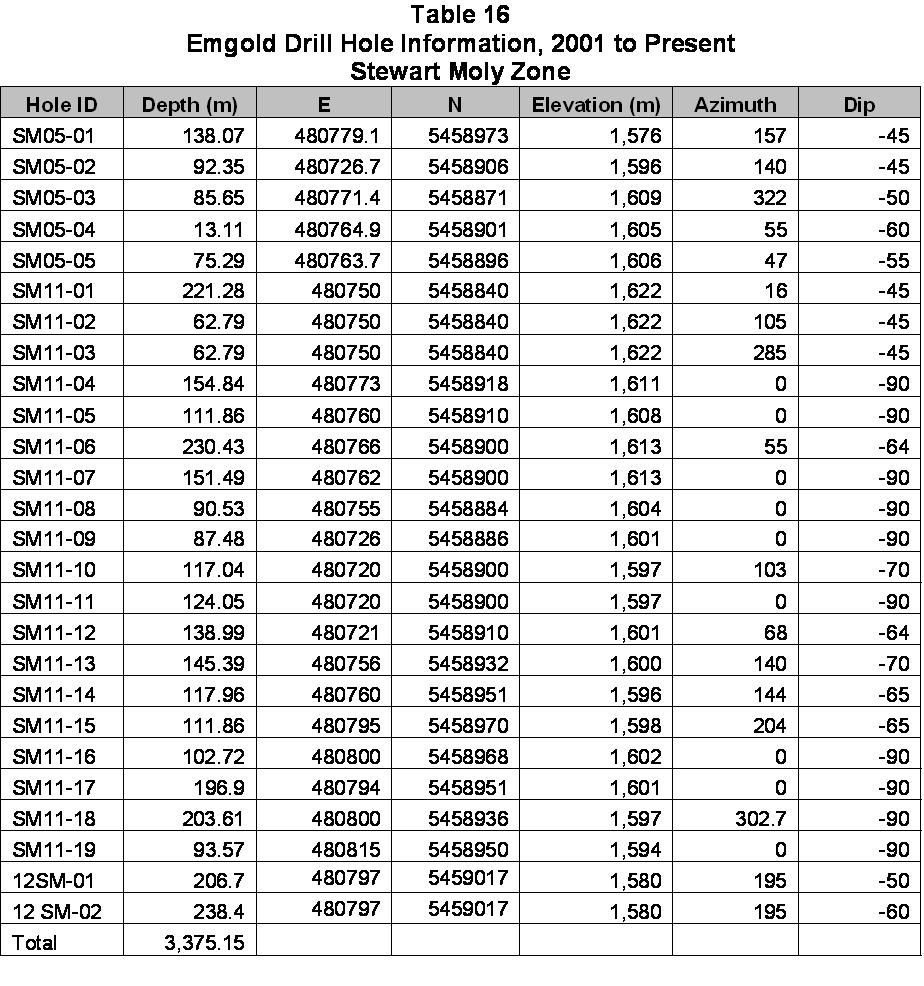
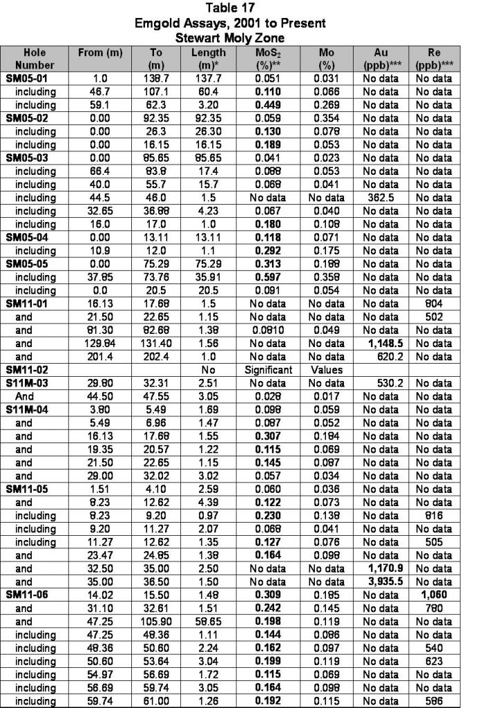
Stewart Moly Zone
The Stewart Moly Zone has been the most extensively investigated of the exploration targets on the Property, and is situated between the Free Silver and Arrow Tungsten Zones. Diamond drilling in the Stewart Moly Zone to date has included 49 holes totaling 6,964.5 metres. Drilling has identified a high grade central zone (breccia) with peripheral low grade molydenum mineralization. Further work is needed to determine the size and ultimate dimensions of this block.
Other potential byproduct metals, including gold and rhenium, have been identified that may play a role in the economics of the Stewart Moly Zone. Rhenium is a rare element used with platinum as catalysts in the production of lead-free, high-octane gasoline. The metal is used in alloys for jet engines and in tungsten and molybdenum based alloys. Nickel based super-alloys for use in jet engines contain up to 6 percent rhenium, making jet engine construction the largest use for the element, with chemical industry catalytic uses being the next most important. It is widely used as filaments for mass spectrographs. Rhenium is also used as an electrical contact material. Because of low availability relative to demand, rhenium is among the most expensive industrial metals. The average rhenium North American Spot Metal Price (99.9% Re) on January 1, 2012 was US$4,359.64 per kilogram (source metalprices.com).
In addition to base metals, gold is also present in the Stewart Moly Zone, as seen in drilling results. Only limited gold sampling has been done on the Stewart Moly Zone to date, based on core visually selected by geologists, and further testing will be needed to determine the significance of gold.
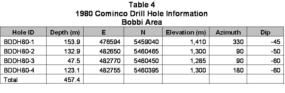
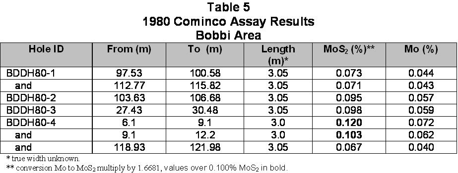
Bobbi Moly Zone
The Bobbi Moly Zone is located northeast of the Stewart Moly Zone and has yet to be drilled by Emgold. Little is known about this area although the historic drilling has included four diamond drill holes totaling 457.4 metres with results indicating the presence of low grade molybdenum. Further exploration is needed to determine the Bobbi Moly Zone is associated with Stewart Moly Zone.
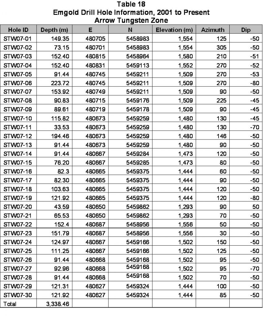
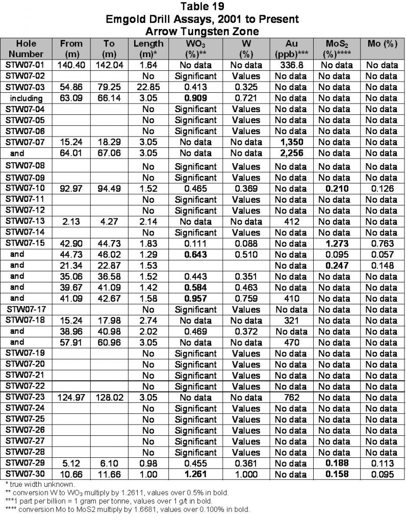
Arrow Tungsten Zone
The Arrow Tungsten Zone is located north of and in close proximity to Stewart Moly Zone. Diamond drilling in the Arrow Tungsten Zone to date has included 30 holes totaling 3,338.5 metres that indicated the presence of low grade tungsten. Detailed information on the drill results above are outlined below. Emgold’s exploration efforts are currently focused on exploration of the Craigtown Creek Gold Zone, the Stewart Creek Gold Zone, and the Free Silver Zone to further analyze the precious metal potential of the property.
LOCATION AND OWNERSHIP
The Stewart Property is located seven kilometres north of Salmo and just west of Ymir, in southeastern British Columbia. The Property is centered on Latitude 49º17’N and Longitude 117º16’W within map sheets 82F/024 and 82F/034. Access to the property is either via the Erie Creek Road, four kilometres west of Salmo on Highway 3, or by the Stewart Creek Road, four kilometres north of Ymir on Highway 6. The property consists of 28 contiguous mineral tenures (claims) covering 5,789 hectares, all of which are 100% owned by Emgold Mining Corporation. The property is subject to a 3 percent underlying Net Smelter Royalty. Emgold retains the right to purchase 2 percent of the underlying Royalty by making a $1,000,000 payment to the underlying royalty holder.
HISTORIC EXPLORATION BY OTHERS
As a poly-metallic property, Stewart has been explored by a number of companies over the years looking for various metals. Exploration activity on the property reportedly goes back to the late 1800’s. In general most of the work was focused on exploring for tungsten and base metals from the 1940’s through the 1960’s. A relatively minor amount of gold exploration was completed in the late 1980’s and 1990’s. Emgold’s assessments have considered all of those metals in the 2000’s.
Premier Gold Mining Company (1942) conducted the initial exploration of Stewart on the Arrow Tungsten prospect. Tungsten mineralization was identified along a 300 meter strike length, with samples up to a few feet wide showing grades reported to be over one percent WO3. This was the first recorded work on the Stewart Property, but Emgold has no reports from it.
Copper Horn Mining Limited (1967) explored for molybdenum. They staked claims, mapped geology, conducted reconnaissance soil geochemistry sampling, and completed magnetometer geophysical surveys (Manning, L.J. 1967).
In 1969 Quintana Minerals Corporation conducted geological and geochemical investigations that resulted in the definition of two copper-molybdenum zones (Gordon, Terrence M., and Malone, A.S. 1970).
Union Carbide acquired and explored the Arrow tungsten area in 1977. They did geochemical surveying for tungsten, molybdenum, copper and zinc (Davidson, Alex, 1978).
Asamera Oil Corporation (1979-1980) carried out a geochemical exploration program on the Bobbi claims on the eastern part of the Stewart property for molybdenum (Barclay, S.W., 1979, 1980).
In 1979 through 1981 Shell Canada Resources Ltd. optioned the property and carried out a detailed evaluation over large areas of the property that included geological mapping, magnetometer and impulse EM geophysics, soil geochemistry and diamond drilling. Much of this work (including extensive drilling) was focused on the Stewart Moly area, with the results suggesting that a molybdenum-bearing porphyry system might exist on the property (Turner, G.W. 1980, 1981).
Cominco Limited (1980) conducted geophysical surveys for porphyry molybdenum deposits on an eastern section of the Stewart property known as the Bobbi claims, an area located approximately two kilometres east of the Stewart Moly Zone. Cominco ran 8.8 kilometres of induced polarization and field magnetic lines and summarized the findings in a report that year. They also completed four drill holes (BDDH801 to BDDH804) within the Bobby area to tests several anomalies (Scott Alan, 1980).
Selco Inc. (1982-1984), a division of BP Exploration Canada Limited, conducted extensive exploration on the property for metals, primarily molybdenum. In 1982 Selco did airborne EM and magnetics surveys and rock chip sampling, and in 1983 they continued with geological evaluations, further geochemical sampling, ground geophysics, and core drilling. Much of their work was on the Stewart Moly Zone. Selco concluded that Stewart contained many showings of base and precious metals. While they thought that the potential would be too small for Selco or BP, they stated that the “property does, however, contain potential for lode deposits which would be amenable to mining by a junior sized mining company…” (Carpenter, T., 1983, 1984).
Selco’s drill program was designed to test areas away from the main molybdenite-bearing breccia body. This drilling met with limited success, with only two samples returning molybdenum values over 500 ppm over 1.0 metre intervals.
Lacana Mining Corporation conducted geochemical sampling in 1987 and summarized the results in a 1988 report. They concentrated on the Rest Creek area, but failed to find targets for further testing (Johnson, D., and R., Klassen), 1987).
Minnova Incorporated (1989-1990) explored the northwest part of the Stewart property in the Craigtown Creek area for gold with soil geochemistry sampling. They also split and re-assayed some historic drill core (Gilmor, W., 1990, Burg, C., 1991).
Cameco Corporation focused on the Craigtown Creek area with programs in years 1992 and 1993. The 1992 program included geological mapping, soil and rock sampling, and backhoe trenching. In 1993 Cameco drilled four core holes and found anomalous gold values ranging with lows in the 10-100 part per billion range up to 24,854 part per billion over one meter in a quartz-sulphide vein. Cameco also ran induced polarization and magnetics geophysics surveys (Humphreys, N., 1992, 1993).
In 1995 Orvana Minerals acquired the Stewart Property to “characterize potentially economic mineralization known to occur on the property” and to develop exploration drilling targets. Their focus was primarily on gold and copper. In 1996-1997, Orvana Minerals conducted geologic mapping, rock, soil and moss mat geochemical sampling, and a ground magnetic and VLF-EM survey, emphasizing the Craigtown Creek area. Orvana described the results of their field work in detail in two reports dated 1997 and 1998, and the conclusions/recommendations in those reports outlined favorable exploration targets to be evaluated during the next field season (Fredericks, Robert, and Thomson, Ian, 1997, 1998).
Kaufman conducted geological evaluations of the property in 1995 and again in 1998, which included writing assessment reports during those years. In addition to geological interpretations, he also examined prior geochemical anomalies, and concluded that potential exists for significant gold mineralization (Kaufman, M. 1995, 1998).
Historic exploration of the Stewart Property has included geochemistry, geophysics, trenching and drilling, resulting in the drilling of 27 diamond core holes for a total of 4,038 metres. Work is documented in assessment reports on file with the B.C. Ministry of MInes and historic data match modern results. As such, it can provides a guide to current exploration activities.
HISTORIC EXPLORATION BY EMERGENT (2001 to Present)
Emgold Mining Corporation acquired the Stewart Property from Jack and Eric Denny in the year 2001. Emgold originally optioned the property for its gold potential but eventually conducted exploration for other previously discovered metals. In the year 2002 Emgold conducted soil geochemistry sampling to verify prior historic work (Dandy, 2002),
In 2003 Emgold added airborne geophysics (magnetics, resistivity, and electromagnetics) (Walcott, P., and Associated, 2004).
In 2004, Emgold completed prospecting, rock, and soil sampling of the Free Silver and Craigtown Creek Zones and diamond drilling of six core holes in the Craigtown Creek Zone. Results indicated anomalous gold-copper and/or minor molybdenum mineralization in the Craigtown Creek Zone. Twenty-nine samples were collected in the Free Silver Zone with an average grade greater than 65 grams per tonne silver. (Brown J., and Dandy L., 2005).
Emgold drilled five core holes in 2005. The program tested historic drill results in the Stewart Moly Zone by twinning two of the Shell Minerals 1980-1981 drill holes. Shell Minerals’ holes numbered 81-3 and 81-9 were twinned by Emgold holes SM05-01 and SM05-02. Drillhole SM05-03 was drilled in the opposite direction of previous drilling to test geologic trending, and holes SM05-04 and SM05-05 were drilled through the breccia body to determine potential grade. Drillhole SM05-04 was discontinued at a shallow depth due to difficult drilling conditions (Grunenberg, P., 2006).
In 2007, Emgold conducted a trenching and diamond drill program over several areas of the property. A total of 28 trenches and 30 diamond drill holes were completed on the property. The program focused the Arrow Tungsten Zone, but also tested the margins of the Stewart Moly zone (Grunenberg, P. 2008). The two zones are closely related, where molybdenite-bearing granitic rocks come into contact with the surrounding sedimentary rocks, creating tungsten-bearing skarn.
In 2011, Emgold completed additional diamond drilling of the Stewart Moly Zone. Nineteen drill holes were completed to get a better understanding of the extent of the Zone and the distribution of high and low grade molybdenum mineralization within the breccia. The element rhenium was also discovered. Both rhenium and gold may be potential byproduct metals in the deposit.
In 2012, the Company completed 11 diamond drill holes. Three holes tested the Stewart Creak Gold Zone, discovering a new gold exploration target. Six holes tested the Free Silver Zone, discovering a base metal exploration target with showing low grade lead and zinc mineralization. Two holes were drilled into the Stewart Moly Zone, to test the extension of the mineralization at depth.
Significant drill results for drilling completed by Emgold from 2001 to present are outlined in Tables 10 to 19 below.
Historic exploration done by Emgold on the Stewart Property has included geochemistry, geophysics, trenching and drilling. In total, including historic work done by others, 102 drill holes and 13,737.2 metres of drilling have been completed to date. Work done by Emgold at the Stewart Property has been done under the supervision of Linda Dandy, P.Geo., or Perry Grunenberg, P.Geo., both of whom are Qualified Persons as defined by National Instrument 43-101. Assay work was done by ACME Laboratories, an independent laboratory, using standard assaying procedures. ACME Laboratories is ISO 9001 certified.
GEOLOGY AND MINERALIZATION
The Stewart Property is located in a region of much historic mining activity, with the Ymir, Erie, Sheep Creek and Nelson districts running in a north-south trend and being sites of extensive exploration and production for over 100 plus years. Stewart is located in the middle of this large geologic trend of gold, molybdenum, tungsten, silver-lead-zinc, copper, and other mineralization. The trend contains:
- Emgold’s Rozan Property (gold, silver-lead-zinc, molybdenum, tungsten);
- Emgold’s Stewart Property (gold, silver-lead-zinc, molybdenum, tungsten);
- Prize Mining Corporation’s Kena Property (gold);
- Margaux Resource’s Jersey Emerald Property (tungsten, lead-zinc, molybdenum);
- Armex Mining Corporation’s Yankee Dundee Property (gold); and
- Valterra Resource Corporation’s Swift Katie Property (copper).
The Property is located in the Ymir Camp of the Nelson Mining District of British Columbia. It s located south of and abuts the Kena Property, owned by Prize Mining Corporation. The Kena Propperty as a indicated resource of 24.9 million tonnes at an average grade of 0.60 grams per tonne gold containing 481,000 ounces of gold and a inferred resource of 85.8 million tonnes at an average grade of 0.48 grams per tonne gold containing 1,318,000 ounces of gold (source: Technical Report for the Kena Project, Nelson B.C., Giroux and Park, Report Date January 16, 2017, Effective Date January 7, 2017, Revised Date: June 2, 2017).
It is west and adjacent to the historic Yankee Dundee Property which contains one of the largest historic gold and silver mines in the Ymir Camp. The B.C. Ministry of Energy, Mines, and Natural Gas data (available at www.minfile.gov.bc.ca) indicates the Yankee Girl Mine produced an estimated 375,000 tonnes of ore at an average recovered grade of 10.26 gram per tonne gold and 13.51 gram per tonne silver between 1907 and 1951. The Ymir Camp produced 883,000 tonne of ore at an average recovered grade of 12.67 grams per tonne gold and 60.23 grams per tonne silver between 1896 and 1980.
While the presence of historic gold and silver production on the Kena Property, Yankee Dundee Property and in the Ymir Camp does not imply similar results will be achieved at the Stewart Property, geologic mapping and geophysics does show similar geologic structures that overlap the Stewart Property and indicate the Property has good exploration potential for discovery of mineral resources.
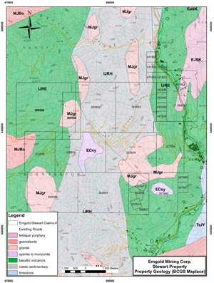
Geology and mineralization of the Stewart Property is well understood following the various exploration programs that have been undertaken over the years, including Emgold’s work. Refer to the Stewart Property Geology Map.
Regional Geology
The oldest rocks in the region are clastic sedimentary rocks of the Proterozoic Aldridge (Belt) Supergroup, which outcrop in the eastern part of the region. The main bedrock units consist of Paleozoic clastic and carbonate sedimentary rocks of the Kootenay Terrane, also situated in the eastern part of the region, and Mesozoic volcanic rocks of the Quesnel Terrane to the west. The stratigraphic units of both the Kootenay and Quesnel Terranes have been folded and faulted along an east-west compressional axis. They are intruded by felsic volcanic rocks that range in age from Jurassic to Tertiary. Small coeval dioritic intrusions are common in the mafic andesitic volcanic rocks of the Jurassic Rossland Group. Extensive late Mesozoic intrusive activity produced the widely distributed Nelson Group of intrusives of granitic to dioritic compositions. Monzonite intrusive rocks of the Eocene-age Coryell Group, are also widely distributed in the region. Young (Tertiary) dikes and sills of rhyolite and felsite are common, and some small, more mafic intrusives are present.
Property Geology
The Stewart Property is underlain primarily by sedimentary and volcanic rocks of the Jurassic Rossland Group, along with intrusive rocks of various younger ages. These rocks have been structurally deformed and faulted, and mineralization appears to be structurally controlled.
Rossland Group
Rocks of the Rossland Group are the Elise Formation, composed of volcanic lithologies, and the Hall Formation, consisting of clastic sedimentary rocks.
The Jurassic age Elise Formation is mostly of basaltic to andesitic composition, but range from andesite to gabbro. The formation includes flows, breccias, pyroclastics, and sub-volcanic intrusives. Diorite intrusives occur in the andesite pile and make up a significant part of the formation. These rocks range from very weakly to moderately magnetic. The volcanics underlie a large portion of the Craigtown Creek area, and host a significant part of the known mineralization. They strike generally north-south and dip moderately to steeply east.
Overlying the Elise Formation on the east is the Hall Formation. Rocks of the Hall Formation are mostly siliceous argillite, siltstone, fine-grained sandstone, conglomerate, and tuffaceous rocks. These rocks strike north-south and dip steeply. Mineralization of these rocks on the Stewart property seems to be restricted to the contact aureole around the “West Moly Intrusion”, to the east. This mineralization is limited to disseminated pyrite/pyrrhotite and minor small quartz-sulphide veins. Alteration in this aureole includes silicification and hornfels.
Intrusives
The Cretaceous Nelson intrusive suite consists mostly of quartz monzonite, monzonite, granite and diorite. The intrusive masses tend to be large, and outcrop most extensively in the northern portion of the property, in the Stewart and Craigtown Creek drainages. Smaller stocks occur in the western portion of the property. The rocks exhibit weak to fairly strong magnetism and propylitically altered near contacts with country rocks. These rocks are important because the porphyry molybdenum mineralization on the property is thought to be related to these intrusives.
Younger intrusives of the Coryell Suite (Eocene or later?) are also monzonitic, but tend to be a little more quartz-poor and alkaline than the Nelson rocks. They occur in both the east central and west central portions of the property.
Younger igneous rocks include intrusive breccias that show several cross-cutting relationships. They are altered and mineralized, and are associated with anomalous Au and Cu geochemistry in both soils and rocks. Several percent magnetite is a common component, both as fine to medium-grained disseminations and as stockwork veinlets, with or without quartz. Potassium feldspar and quartz veining and flooding are present in places.
The youngest intrusives are rhyolite, latite and minor basalt sills/dikes that intrude the older Rossland rocks and both Nelson and Coryell intrusives. They are also probably Tertiary age, as they intrude the Rossland Group and the diorite and monzonite intrusives. They generally strike north-south and dip near vertically. The dikes are a few metres in width and have strikes that range from northwest to northeast with steep dips. They are usually not altered or mineralized, however, a small plug of a trachytic latite and quartz latite porphyry with quartz veinlet stockwork and anomalous Au (>1 g/t) outcrops in the Craigtown Creek area.
Rhyolite, lamprophyre, porphyritic basaltic dikes and small plugs occur on the Stewart Property. Some of them contain disseminated pyrite and some earlier workers concluded that they are the source of the Au soil geochemical anomalies at Craigtown Creek. They also intrude the Rossland Group and the diorite and monzonite intrusives. They are probably late and unrelated to mineralization.
Structures
The dominant structural grain on the property is north-south. The Rossland Group stratigraphy generally strikes north-south, and the Elise and Hall Formations were folded into a broad north-south trending syncline (Hall Creek Syncline) that runs through the property and extends both north and south over a 20 kilometer strike length. Northwest and northeast-trending faults and shear zones exist on the property and appear to be significant controls to mineralization. The younger rhyolite dikes and sills also strike north-south and dip steeply.
Alteration
Various types of alteration have been observed on the Stewart Property. In the area of the porphyry molybdenum occurrences phyllic and potassic alterations were reported by earlier workers. Silicification is common in various rock types. Propylitic alteration of intrusive and volcanic rocks is widespread on the property. In the Craigtown Creek area propylitic, silicification, carbonate, potassic and skarn alterations are present.
Propolylitic alteration, silicification and carbonate alteration are present within the Elise Formation andesite near Craigtown Creek. The silicification is usually accompanied by disseminated pyrite or pyrrhotite and is coincident with gold-copper-arsenic anomalous soil and rock geochemistry in places. Most of the carbonate appears to be a late alteration product.
Potassic alteration is present in places in brecciated and veined fine-grained felsic monzonite intrusive rocks along the Bonnington Pluton/Elise Formation contact. Quartz +/- magnetite veinlets are commonly associated with this alteration.
Stewart
Geology Map
MINERALIZATION
Mineralization on the property is widespread and varied, as shown on the Stewart Property Soil Geochemistry Map. Included are porphyry molybdenum within intrusive breccia (Stewart Moly Zone), contact/skarn related molybdenum and tungsten (Arrow Tungsten Zone), porphyry stockwork gold/copper (Craigtown Creek Area), stratabound sediment hosted gold-rich sulphides (Arlington Mine, Gold Hill), quartz-pyrite-arsenopyrite stockwork in sediments (Trixi V), sediment hosted silver-zinc-lead (Free Silver Zone), and quartz-pyrite veins with gold (Craigtown Creek).
Gold
Several areas have shown indications of gold, which could become an important byproduct or stand-alone metal to be included in assessments at Stewart. Rock chip sampling of surface outcrops has detected gold in several areas.
Surface rock sampling of the Arrow Tungsten Zone has shown spotty gold assays plus visible gold in vuggy quartz. Emgold’s exploration of the Stewart Moly Zone also detected gold. Trenching assay results included a three meter wide chip sample that assayed 1,445 part per billion gold.
In the Craigtown Creek area, six types of mineralization are known. These include:
- Disseminated and fracture filling pyrite and/or pyrrhotite, +/- chalcopyrite;
- Quartz-magnetite veinlets;
- Quartz veinlet stockwork;
- Pyrite veinlets;
- Quartz-carbonate veins; and
- Quartz-sulphide veins.
Pyrite and pyrrhotite as disseminated grains and fracture fillings is common in the Craigtown Creek area. This type of sulphide is also very common in feldspar porphyry. In one area disseminated and fracture-filling pyrite and pyrrhotite in andesite tuff consistently assayed 1 to 2 grams per tonne gold in rock samples.
Quartz-magnetite veinlets are common in the north-northwest trending contact zone between the felsic monzonite intrusives and the Elise volcanics. This zone has strongly anomalous gold and copper in soils. Where sampled on the surface, rocks containing this type of mineralization contain anomalous gold (100 to 300 part per billion range) and copper (200 to 500 part per billion range).
Quartz and quartz-pyrite veinlet stockwork was observed in feldspar porphyry float in several places and in a small latite plug. Several samples have returned gold values greater than 1 gram per tonne gold.
Pyrite veinlets in mafic andesite-basalt contain highly anomalous gold values in a portion of the area explored by Minnova east of Craigtown Creek. Samples of veinlets have run in the 8 to10 gram per tonne gold range.
Quartz-carbonate veinlets are present in both the Bonnington Pluton monzonite-diorite intrusive rocks and the Elise volcanics. Samples of these rocks have weakly anomalous gold and copper.
Quartz-calcite-sulphide veins in Elise volcanic rocks were intersected in one of the 1994 Cameco drill holes. One of these veins contained 24.8 grams per tonne gold over one meter. It is possible that gold-in-soil anomalies located north of Craigtown Creek are related to this type of mineralization.
In 2012, Emgold intersected gold in drilling of the Stewart Creek Gold Zone, This Zone was discovered veining exposed in rock cuts by new logging roads that were constructed in the area. Additional work is required to better understand the mineralization and veining in this area.
Silver, Lead, Zinc
The Free Silver area consists of a cluster of historic showings, located in the southeast portion of the Property. The original Free Silver Claims were staked in 1896. Early work completed on the claims consisted of small trenching programs in 1906 and 1915. In 2004, Emgold completed a trenching program including grab and rock chip sampling of the Free Silver Zone. Nineteen out of 29 samples had grades ranging from 1.1 to 641 g/t silver, zero to 18.3% lead, and 0.03% to 25.89% zinc (see November 26, 2012 press release for additional details). No diamond drilling was carried out in the area until the 2012 program.
A number of parallel to sub-parallel veins occur at the contact of volcanic rocks with a quartz monzonite porphyry. The veins vary from 0.1 to 3.0 m wide and trend in an east-west direction and dip steeply. Mineralization varies from massive pyrite-pyrrhotite to galena with subordinate pyrite and sphalerite. Minor molybdenite is reported locally within the veins. Sylvanite can be found in calcite filled vugs in an andesite host (occurring as a xenolith in monzonite) and is associated with trace amounts of chalcopyrite and galena.
Emgold’s 2012 drill program included a total of six diamond drill holes at three locations in the Free Silver Zone. Holes were drilled to test veins that had been identified by trenching and sampling in 2004 looking for silver, lead, and zinc mineralization.
Drilling encountered low grade lead and zinc mineralization, with minor amounts of gold and silver, in every hole. This included several long intersections in drill holes 12FS-01 (17.55 m), 12FS-02 (26.00 m and 30.34 m), 12FS-03 (11.45 m and 11.20 m), FS-04 (31.60 m and 25.40 m). Note that these are sample lengths, not true widths. The 2004 and 2012 results indicate that, there may be potential for lower grade bulk tonnage base metals and higher grade veining located in the Free Silver Zone.
Molybdenum
The most extensive zone of molybdenite mineralization found on the property thus far, located in the Stewart Moly Zone, is within intrusive breccia and forms a podiform, vertically dipping zone. Mineralization is primarily fine grained disseminations of molybdenite within the matrix but it also occurs as selvages associated with quartz veinlets transecting fragments, and as fracture fillings. Additional molybdenum mineralization has been found in the Bobbi Moly Zone drilled by Cominco Ltd.
Between1980 and 1983, Shell Minerals and Selco drilled 23 diamond core holes in the Stewart Moly Zone, and within this breccia zone, Shell concluded that mineralization was in breccia pipes. Emgold’s exploration drilling of the Stewart Moly Zone further defined that area to be a steep dipping elliptical-shaped (pipe-like) breccia body (see Stewart Moly Zone Map). Selco suggested the possibility of porphyry style molybdenum mineralization occurring adjacent to this breccia zone. In 1980, Cominco Limited drilled four diamond core holes in the Bobbi Moly Zone intersecting low grade mineralization.
Tungsten
Tungsten mineralization occurs as scheelite and is primarily found in skarny sections of metasedimentary rocks, and located in the Arrow Tungsten Zone. Trenching of the Arrow Tungsten Zone has shown tungsten mineralization with values of 1.171% tungsten over widths of two metres and 0.594% over five metres. Diamond drilling results from the Arrow Tungsten Zone included 22.9 metres of 0.413% WO3 representing lower grade material and 1.58 metres of 0.957% W O3 representing higher grade material Significant intercepts occurred to the west of any known tungsten mineralization, which may represent a parallel zone that has not yet been evaluated.
Sampling of the Bobbi claims also showed the presence of molybdenum, tungsten and zinc mineralization.
Rhenium
Rhenium, which appears to associate with molybdenite, has been identified in Emgold drill core within the Stewart Moly Zone. This rare metal may be included in future assays to determine its potential significance to the deposit. Rhenium is a rare element used with platinum as catalysts in the production of lead-free, high-octane gasoline. The metal is used in alloys for jet engines and in tungsten and molybdenum based alloys. Nickel based super-alloys for use in jet engines contain up to 6 percent rhenium, making jet engine construction the largest use for the element, with chemical industry catalytic uses being the next most important. It is widely used as filaments for mass spectrographs. Rhenium is also used as an electrical contact material. Because of low availability relative to demand, rhenium is among the most expensive industrial metals. The average rhenium North American Spot Metal Price (99.9% Re) on January 1, 2012 was US$4,359.64 per kilogram (source metalprices.com).
Stewart
Exploration Targets to Date
CURRENT EXPLORATION ACTIVITIES
The Company plans to focus on exploration for gold and silver In future drilling programs on the Property including the Craigtown Creek Gold Zone, Stewart Creek Gold Zone, and the Free Silver Zone.
RESOURCES
The Stewart Property is an early stage exploration property, and no NI 43-101 compliant resources exist at this time.
MINING
Exploration would target veins and disseminated deposits suitable for mining by either surface or underground methods. Most historic exploration appears to have been searching for deposits that could be mined by surface methods.
METALLURGY
Selection of a metallurgical process would be determined following additional exploration activity, metallurgical test work, and economic studies.
CONCLUSIONS
The Stewart Property lies within a regional geologic trend of mineralization and hosts a variety of mineral occurrences. To date, work on the Property has defined significant zones of molybdenum, tungsten and gold mineralization, indicating polymetallic occurrences. Results from most of the exploration programs undertaken on different parts of the property have shown the presence of mineralization. In addition, much data is available from those programs to use in future exploration.
Although many reconnaissance exploration programs have been conducted at Stewart over the years, most of the work has been conducted near-surface and would be considered early stage exploration. The various exploration programs have focused on specific metals and/or types of deposits, and in certain locations, so it appears that there has not been an in-depth search for one metal type over all the claims (as is the case for gold). Drilling has been localized, and very little deep drilling has been done. As a result, the overall potential of Stewart may not yet be known for gold, silver, molybdenum, tungsten, or other base metals.
Emgold believes that the Stewart Property has very good potential to host a large mineral deposit, but a large-scale exploration program will be required to adequately make this assessment. This program would require deep drilling to test for mineralization at depths greater than previously assessed, and might require more geochemistry or geophysics to define exploration targets.
For these reasons, Emgold is seeking opportunities to advance its Stewart Property through a lease, joint venture or other means. Emgold is encouraged by the results of prior exploration but feels that future exploration should consider the whole property.
QUALIFICATION
Technical information included on this web page has been reviewed and approved by Perry Grunenberg, P.Geo., a Qualified Person as defined by National Instrument 43-101.
REFERENCES
Barclay, S.W., Geo-chem Report, Bobby Group, Stewart Creek, Asamera Oil Corporation, Assessment Report 7656, 1979.
Barclay, S.W., Prospecting Report, Eleanor Group, Asamera Oil, Assessment Report 8017, 1980.
Brown, J., and Dandy, L., Geological, Geochemical, and Diamond Drilling Report on the Jazz Property, Emgold Mining Corporation, Assessment Report 27640, 2005.
Burge, C., 1990 Summary Report Stewart Option, Minova Incorporated, 1990).
Carpenter, T., Assessment Report, Selco Inc., Assessment Report 12251, 1983.
Carpenter, T., Assessment Report, Selco Inc., Assessment Report 13166, 1984.
Dandy, L., Geological and Geochemical Report on the Stewart Property, Emgold Mining Corporation, Assessment Report 26863, 2002.
.
Denny, E., Geochemical, Linecutting, and Prospecting Report on the Stewart Property, Assessment Report 7074, 1979.
Davidson, A., Geochemical Report on the Atlanta and Consolidated Alabama Mineral Claim, Union Carbide Canada Limited, Assessment Report 6654, 1978.
Fredericks, R., and Thomson, I., Report of 1996 Geological, Geochemical and Geophysical Exploration Program, Stewart Property Orvana Minerals, Assessment Report 24789, 1997.
Fredericks, R,, and Thomson, I., Report of 1997 Geological, Geochemical, and Physical Work Program, Stewart Property, Orvana Minerals, Assessment Report 25338, 1998.
Gilmor, W., Summary Report on the Stewart Property, Minova, Assessment Report 19704, 1990.
Grant, B., Assessment Report, Selco Inc. Assessment Report 11670, 1983.
Gordon, T., and Malone, A.S., Geological and Geochemical Report, Salmo Claim Groups, Quintana Minerals Corp., Assessment Report 2301, 1970
Grunenberg, P., Diamond Drilling on the Stewart Property, Assessment Report 28202, 2006.
Grunenberg, P., Trenching on the Stewart Property, Emgold Mining Corporatipn, Assessment Report 29755, 2008.
Grunenberg, P. Diamond Drill and Rock Sampling Report on the Stewart Property, Emgold Mining Coporatoin, 2011
Grunenberg, P. Diamond Drilling Report on the Stewart Property, Emgold Mining Corporation, Assessment Report 33456, 2013.
Hoy T., and Andrew, K, Geology of the Nelson Map Area, Southeastern British Columbia: BC Ministry of Energy, Mines and Petroleum Resources, Open File 1989-1.
Hoy, T. and Andrew K., The Rossland Group, Nelson Map Area, Southeastern British Columbia: BC Ministry of Energy, Mines and Petroleum Resources, Geological Fieldwork, 1988, Paper 1989-1.
Humphreys, N., Final Report on the Geology, Geochemistry and Trenching on the Denny Prospect, Cameco Corp., Assessment Report 22829, 1992.
Humphreys, N., Report on the Diamond Drilling on the Denny Prospect, Cameco Corp., Assessment Report 23092, 1993.
Johnson, D., and R., Klassen, Report on 1987 Geochemical Sampling, Lacana Mining Corporation, 1987.
Kaufman, M., Stewart Claim Group Assessment Report, Assessment Report 24123, 1995.
Kaufman, M., Craigtown Creek Gold Anomaly Area, Assessment Report 25702, 1998.
Manning, L.J. Geochemical, Magnetometer and Geological Surveys of the Fresno Group, Copper Horn Mining Ltd., Assessment Report 1083, 1967.
Scott, A., Geophysical Report on Induced Polarization and Magnetics Surveys, Bobbi Group, Asamara Oil Corp. and Cominco Limited, Assessment Report 8448, 1980.
Turner, G.W., Assessment Report, Stewart Claims, Shell Canada Resources Ltd., Assessment Report 7722, 1980.
Turner, G.W., YMIR Project, Shell Canada Resources, Assessment Report 10072, 1981.
Walcott, P.. and Associates, Report on Heliborne Magnetic & Electromagnetic Surveying, Emgold Mining Corporation., Assessment Report 27454, 2004
Note: Assessment Reports can be found at the B.C. Ministry of Mines ARIS Website.
DISCLAIMER
Readers are cautioned to review the Disclaimer Page on this website for qualifications that may be applicable to the information contained on this Project Page, including Forward Looking Statements.