Location Quebec
Location Details 11 km west of Val d’Or
Type of Project Exploration
Number of Claims 7
Est. Size of Property 184 ha
Emgold Ownership First Option to acquire 50% with Second Option to increase ownership to 55%
Underlying Royalties Pratt Royalty – 1.75%, can be purchased at any time for C$1.5 million
Vendor Royalty – 1.75%, 0.5% can be purchased at any time for C$0.5 million
Exploration Completed Trenching
Soil and rock chip sampling
Geophysics
280 drill holes totaling 58,728 m
Key Exploration Targets East and West Zone
Technical Report NI 43-101 Technical Report Pertaining to the East-West Property, Val d’Or Area, Northwestern Quebec, Abitibi Region NTS 32C04, Prepared for Knick Exploration Inc. by Donald Theberge, P. Eng. M.B.A., November 21, 2017.
Resources None yet defined
Highlights Small strategically placed property between two past producing mines, Kiena and Marban. The Marbanite Fault, associated with mineralization found on all three properties crosses east-west across the Property, hence the name. Extensive drilling has been done, but at a relatively shallow depth of less than 200 m. Property of merit for further exploration. Extending the East and West Zones at depth should be a high priority.
East-West Property, QC
Emgold is in the process of acquiring 55% ownership in the East-West Property, Quebec (the “Property”). The Property is located in the Val d’Or Mining Camp on strike, west of, and adjacent to Wesdome Gold Mines Ltd. (TSX: WDO) Kiena Complex which hosts the past producing Kiena Mine. The Kiena Complex produced more than 2.8 million ounces of gold from 1981 to 2013 and has a permitted 2,000 tonne per day milling and refining complex currently on care and maintenance. It is also on strike, east of, and adjacent to Osisko Mining Inc.’s (TSX: OSK) Marban Block Property which contains three past producing Mines (Marban, Norlartic, and Kierrans) that produced more than 590,000 ounces of gold. The Property appears to be situated on the Marbenite fault and deformation corridor and has similar mineralized structures that trend through the adjacent Kiena and Marban Mines.
Summary
On December 11, 2019, Emgold announced it had signed a Claim Purchase and Option Agreement giving it the Company the option (the “First Option”) to acquire up to a 50% interest in the Property from a private individual (the “Vendor”). The remaining 50% interest in the Property is owned by Knick Exploration Inc. (“Knick”) (TSXV: KNX). Emgold has also acquired, as part of the Transaction, a second option (the “Second Option”) to increase its ownership in the Property to 55%, as outlined below. The Transaction was approved by the Toronto Venture Exchange (the “Exchange”) on January 3, 2020.
A NI 43-101 Technical Report (see link below) was completed on the Property in 2017 by Knick and is available under Knick’s corporate filings at www.sedar.com. Historic work on the Property, prior to 2007, includes more than 41,000 m in drilling in 180 drill holes. Knick acquired the Property in 2007 and subsequently conducted three drilling programs totaling 17,728 m of drilling in 100 drill holes.
Link to Technical Report
The Property is located in Archean-age rock formation that is part of the Abitibi greenstone belt which lies within the Superior Province of the Canadian Shield. The Property is underlain from north to south by the Jacola and Val d’Or formations of the Kewegama Group. A main fault occurs on the Property called the Marbenite fault, with associated deformation corridor, which strikes approximately NW-SE. Mineralization to date has, for the most part, been found in the vicinity of this fault. Two main zones of mineralization have been identified by drilling to date – the West Zone and the East Zone. Three other zones have also been identified but are at an earlier stage of exploration.
The Marbenite Fault is interpreted to cross the West Zone and is closely associated with the East Zone. Note the Marbenite Fault is also associated with the adjacent Marban and Kiena Mines, located to the NW and SE of the Property, respectively.
Significant drill intercepts (intercepts greater than 10.0 g/t Au and with lengths greater than 1.0 m) from Knick drilling that occurred in 2009, 2011, and 2016/17 include:
- 11.146 g/t Au over 1.95 m from a depth of 52.10 m to 54.05 m in hole LEO-09-21
- 10.080 g/t Au over 1.45 m from a depth of 10.55 m to 12.00 m in hole LEO-09-33
- 31.500 g/t Au over 1.25 m from a depth of 101.95 m to 103.20 m in hole EW-16-06
- 15.191 g/t Au over 2.40 m from a depth of 79.15 m to 81.55 m in hole EW-16-10
- 13.300 g/t Au over 1.10 m from a depth of 260.30 m to 261.40 m in hole EW-17-20
- 10.010 g/t Au over 1.40 m from a depth of 195.20 m to 196.60 m in hole EW-17-27
Significant drill intercepts (intercepts greater than 10.0 g/t Au and with lengths greater than 1.0 m) from historic drilling prior to Knick that occurred between 1984 and 1987:
- 13.13 g/t Au over 1.83 m from a depth of 140.21 m to 142.04 m in hole CD-19
- 10.73 g/t Au over 1.22 m from a depth of 96.77 m to 97.99 m in hole CD-28
- 134.64 g/t Au over 1.68 m from a depth of 145.08 m to 146.86 m in hole CD-55
- 51.98 g/t Au over 3.20 m from a depth of 125.27 m to 127.47 m in hole CD-78
- 24.75 g/t Au over 1.52 m from a depth of 141.43 m to 142.95 m in hole CD-81
- 64.83 g/t Au over 2.75 m from a depth of 137.92 m to 140.67 m in hole CD-149
- 226.70 g/t Au over 2.24 m from a depth of 199.03 m to 201.17 m in hole CD-156
- 64.36 g/t AU over 1.68 m from a depth of 81.99 m to 83.36 m in hole CD-172
Significant drill intercepts (intercepts greater than 3.0 g/t and lengths greater than 3.0 m) from historic drilling prior to Knick that occurred between 1984 and 1987:
- 2.26 g/t Au over 5.49 m from a depth of 89.61 m to 95.10 m in hold CD-84-10
- 4.09 g/t Au over 4.73 m from a depth of 96.01 m to 100.74 m in hold CD-84-10
- 4.14 g/t Au over 3.51 m from a depth of 103.17 m to 106.68 m in hole CD-84-10
- 51.98 g/t Au over 3.20 m from a depth of 125.27 m to 127.47 m in hole CD-78
- 2.11 g/t Au over 3.96 m from a depth of 103.02 m to 106.98 m in hold CD-79
- 1.29 g/t Au over 3.66 m from a depth of 78.94 m to 82.60 m in hole CD-83
- 3.60 g/t Au over 5.49 m from a depth of 210.31 m to 215.80 m in hole CD-92
- 2.79 g/t Au over 7.01 m from a depth of 26.88 m to 43.89 m in hole CD-111
- 1.54 g/t Au over 7.62 m from a depth of 201.32 m to 208.94 m in hole CD-114
- 1.03 g/t Au over 4.58 m from a depth of 70.10 m to 74.68 m in hole CD-145
- 1.20 g/t Au over 3.05 m from a depth of 106.68 m to 109.73 m in hole CD-150
- 3.86 g/t Au over 3.51 m from a depth of 150.72 m to 154.23 m in hole CD-152
- 0.86 g/t Au over 3.04 m from a depth of 159.11 m to 162.15 m in hole CD-161
- 0.69 g/t Au over 6.09 m from a depth of 128.02 to 134.11 m in hole CD-165
- 1.08 g/t Au over 4.12 m from a depth of 208.94 m to 213.06 m in hole CD-169
- 1.38 g/t Au over 3.05 m from a depth of 18.59 m to 21.64 m in hole CD-172
- 1.14 g/t Au over 4.57 from a depth of 32.92 m to 37.49 m in hole CD-173
Drilling indicates the potential for both higher grade intercepts (>10 g/t Au) and lower grade bulk disseminated mineralization (>3 g/t and widths > 3 m). Additional information on these significant intercepts is provided below.
Drilling done by Knick was done to meet NI 43-101 Standards for Disclosure and CIM Standards. Historic drilling prior to Knick was done before the introduction of NI 43-101 Standards and CIM Standards. The true width of individual intercepts is unknown. Emergent's geologists have not verified the historic or Knick results.
Note that there are currently no mineral resources or reserves yet defined on the Property that meet NI 43-101 Standards for Disclosure or CIM Standards. Additional exploration is needed to develop mineral resources.
East-West Property – Drill Site
Source: 2017 Knick East-West Technical Report
Location and Ownership
The Property lies on NTS5 sheet 32C04, in Dubuisson Township. The geographic center of the Property is located at UTM coordinates 279 263E/5 334 664N (Zone 18U NAD83), or approximately 11 km west of the town of Val d’Or. The Property consists of 7 mineral claims totaling 184 ha and is 50% owned by Knick Exploration Inc. and 50% owned by a private party (the ”Vendor)). Emgold has a first option to acquire the Vendor’s 50% interest and also a second option to increase the Company’s ownership to a 55% interest.
East-West Property – Location
Source: 2017 Knick East-West Technical Report
East-West Property Claims
Source: 2017 Knick East-West Technical Report
(no scale, north at top)
Terms of the Transaction
On the closing date, the Vendor granted to Emgold the First Option to acquire 50% ownership and title to the claims comprising the Property and all rights under pursuant to a sale agreement between the Vendor and Knick dated November 27, 2018, as amended on November 29, 2019 (together, the “Sale Agreement”). In exchange, Emgold shall pay the Vendor:
- 4,000,000 common shares in the share capital of Emgold (the “Share Consideration”), to be issued to the Vendor at the Closing Date;
- a cash payment of CAD$35,000 to be paid to the Vendor upon the three month anniversary of the Closing Date;
- a cash payment of CAD$50,000 to be paid to the Vendor upon the six month anniversary of the Closing Date; and
- a cash payment of CAD$50,000 to be paid to the Vendor upon the nine month anniversary of the Closing Date.
Upon completion of the share and cash payments, the Vendor’s Property interest in the claims will be transferred to Emgold.
Emgold will assume the Second Option to earn an additional 5% (total 55%) interest in the Property by completing, along with expenditures already completed by the Vendor, a total of CAD$200,000 in expenditures within three years of the original Sale Agreement between the Vendor and Knick dated November 27, 2018. Emgold will have the right to become the operator of the Property during the First Option Period and potentially the Second Option. Upon completing the First or Second Option, at Emergent's discretion, an industry standard joint venture will be formed with Knick with Emgold as the operator.
The Property has two underlying royalties. A 1.75% NSR (Pratt Royalty) can be purchased at any time by the owners of the Property for C$1.5 million. A second 1.75% NSR (Vendor Royalty) of which 0.5% can be purchased at any time by the owners of the Property for C$0.5 million
Historic Exploration Activities by Others
Up until the end of the 1990s, exploration work was carried out separately on the northern and southern parts of the Property. The southern part of the Property is made up of claims 2415484, 2415485 and 2415486. The northern part is made up of claims 2415483, 2415487, 2415488 and 2415489.
Southern Part:
The first exploration work carried out on the southern part of the Property dates back to 1937. From this
Time, until the beginning of the 1970s, little exploration work was reported. Magnetic prospecting was done by Dubuisson Goldfields in 1937, followed by a geological report by Norman Malartic Mines in 1945. During the next 16 years, no exploration was reported.
In 1961 and 1962, two other magnetic surveys were conducted by Ambassador Mining Development and
Dubuisson Goldfields. After that, nothing happened until 1970, when a new magnetic survey was reported by Gold Resources. Finally, in 1976, three holes totaling 508 m were drilled by Babylon Minerals, but no significant gold grades were reported.
From 1980 to 1984, the mineral claims were registered in the name of Rénald Garneau. Magnetic and
VLF7 surveys were completed at that time, followed by an evaluation report. In 1988, the claims were registered in the name of Black Cliff Mines. Magnetic, VLF and IP surveys were reported, followed by one 68 m drill hole. No significant gold grades were reported. In 1989, the claims were optioned by Malartic Hygrade Gold Mines, and four holes totaling 659 m were drilled. No significant gold grades were reported.
In 1993, the claims appear under the name of Alain Guy Garneau. Nine kilometers of magnetic survey were reported. From 1993 to December 31, 2008, no exploration work was recorded.
Northern Part:
From 1933 to 1940, the northern part of the property was held by West Shore Malartic Gold Mines. Trenches were dug in the eastern part of the Property. A 229 m shear zone striking 070 degrees was discovered, and anomalous gold values were reported.
In 1945-1956, Clarnor Malartic Mines took an option on the claims. Eleven holes were drilled, five of them on part of a stratigraphic section in the eastern part of the Property.
In 1959, the Property was part of a large claim block held by Little Long Lac. A program of geophysical surveys was completed. Holes were drilled on lots 17 and 18, outside the East-West Property. In 1974-
1975, the Property was known as the Audet option. Three holes totaling 1,668 feet were drilled by Babylon Minerals, but no significant gold grades were obtained. In 1979, the three claims corresponding to lots 21, 22 and 23, range 10, were known as the Arnold James Property, and in 1980 they were optioned by Auguste Mitto and William Plexman, who sold them to Cache d’Or Resources.
From 1981 to 1987, Cache d’Or Resources completed magnetic and VLF surveys, followed by 184 drill holes totaling approximately 39,600 m. At the beginning of the 1990s, Cache d’Or Resources became
Exploration Auriginor Inc.
Knick acquired the property in 2007.
Geology, Mineralization, and Structure
The Property is located in Archean-age rock formations that are part of the Abitibi greenstone belt, which lies within the Superior Province of the Canadian Shield. The Property is underlain from north to south by the Jacola and Val-d’Or formations and the Kewagama Group. Contacts between the lithological units are generally faulted and oriented NW-SE, with sub-vertical dips toward the south.
The Jacola Formation covers approximately the NE part of lots 21 to 23, range 10. It is made up of ultramafic flows (komatiites) and basalts. Ultramafic flows are Al2O3-poor, with an average of 5 to 7%, and magnesium-rich (+20% MgO). Basalts are of tholeiitic affinity. These structurally controlled rock formations strikes NW-SE.
The Val-d’Or Formation is made up of mafic to intermediate volcanics. These usually form massive flows but can be locally pillowed or brecciated. They are similar to those of the Jacola Formation. These basalts and andesites are often sheared. They are stratified with units of mafic to intermediate tuffs and cut by many intrusives. The upper contact tested by drilling corresponds to an epiclastic sequence composed of lapillis and bedded tuffs of dacitic composition, interlayered with mafic units. The sequence has been tested by drilling over approximately 150 m.
The Kewagama Sedimentary Group underlies the southern part of the Property. These sediments are made up of an interlayering of siltstone and argillaceous schist. They are often aphanitic.
Geology of the East-West Property
Source: 2017 Knick East-West Technical Report
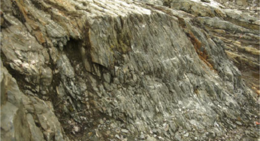
The main fault occurring on the Property is the Marbenite fault, which strikes NW-SE, roughly parallel to the stratigraphy. Its southern limit corresponds to the Jacola and Val d’Or Formation (it is located close to the contact between the Jacola and Val-d’Or formations). Observations from drilling show 50 to 100 m of strong stretching of tuff fragments and a dominant laminated texture. The fault contact position is marked by a pluri-metric talc schist. The typical drilling section of the northern part of the Property cross a succession of high strain zones exploiting contacts between massive mafic to intermediate massive units with komatiite flows of the Jacola Formation over a thickness of about 400 m. A higher deformation level observed is associated with strong chlorite, chlorite-talc, chlorite-talctremolite, and talc carbonate alteration zones. Lamprophyre dykes swarm are commonly embedded in these structures and can also be used to identify faults and shear zones as parts of the Marbenite deformation system.
Example of Shear Zone on the East-West Property
Source: 2017 Knick East-West Technical Reprot
The mineralized zones known to date on the Property are all located in the mafic facies of the Jacola Formation, which also hosts the Marban and Kiena Mines, located NW and SE of the East-West Property, respectively. This formation has a spectacular magnetic signature on the airborne total field map, mainly related to predominant komatiitic flows.
Mineralization is often associated with networks of quartz-tourmaline-ankerite veins in competent basalts/andesites associated with less competent sheared and altered ultramafic flows. Mineralization is in the form of free gold, with specks of gold observed in the drill core. Sulphides content is generally low, with pyrite content usually varying from 0 to 5%. Chalcopyrite is rarely observed. No studies have been done to verify whether gold is associated with the sulphides.
Drilling has identified two main mineralized zones on the Property: the East and West Zones. The West Zone mineralization is associated with a network of quartz-ankerite-tourmaline veins, locally with sulphides (pyrite and pyrrhotite), in an intermediate to mafic lava, itself included in ultramafic flows. The mineralized envelope of the West Zone strikes 110 degrees. It is parallel to, and probably associated with a component of the Marbenite Fault system. This zone is included in a 200 m x 200 m area bounded by UTM coordinates 279 100E, 279 300E, 5 335 000N and 5 335 200N. This Zone has been explored to a depth of 200 m. Since it acquired the Property, Knick has drilled 32 holes on the West Zone area, 20 of which have returned gold grades of over 1 g/t Au.
The usual gold values intersected on the West Zone are in the order of 2 to 3 g/t Au over true widths of less than 1 m. Historical drilling and the drilling done by Knick seem to have defined this zone well, at least to a vertical depth of 200 m.
The East zone is less well defined, being less drilled. It is made up of quart-carbonate veins, sometimes brecciated, containing an average of 1-5% sulphides, mainly as pyrite and pyrrhotite, and more rarely chalcopyrite. It has been traced over a distance of 400 m in an east-west direction, from UTM coordinates 279 900E to 280 300E at 5 334 950N. Knick drilled 19 holes on the East zone in 2009, another four in 2011, and seven more in 2016-17. Sixteen of these returned values of over 1 g/t Au.
Stripping by Knick has revealed at least three new gold zones: Raven, Gilbert and Grand Canyon. All the stripped areas are located in the eastern part of the Property, close to the East Zone.
Geochemistry
Trenching, geological mapping, and grab and channel sampling has was done by Knick. Two trenching programs completed in 2009 and 2010 in the east part of the Property close to the East Zone revealed at least three new showings: Raven, Gilbert and Grand Canyon. The main zone is the Raven Zone, which extends more than 200 m in an ENE direction. Gilbert and Grand Canyon Zones are located 125 m and 90 m south of the Raven zone, respectively.
In each trenched area, gold mineralization was found in quartz veins associated with shear zones. On Raven, quartz veins are located on each side of a gabbroic sill in contact with a quartz feldspar porphyry
(QFP) to the north and a dacite to the south. On Gilbert and Grand Canyon, the quartz veins are included in intermediate volcanics.
Geophysics
On the southern part of the Property, on lot 12 range A Dubuisson, Knick conducted 22.6 km of line cutting, 19 km of magnetic and VLF surveys, and 10.8 km of induced polarization (IP) surveys. In June 2009, the magnetic and VLF-EM surveys were done. The magnetic survey provides information on the magnetic image of the underlying rock formations and contacts between the different geologic units. The VLF-EM survey provides information on several W, NW-E, and SE conduction and resistive zones potentially associated with structural features. The IP survey was conducted between May and June 2009 and defines a wide resistive corridor oriented along and east-west direction and hosing several attractive IP anomalies. In May, 2010, a hole to hole 3D IP survey was conducted identifying eight separate anomalies for follow up.
Drilling
A historical archive of drilling was assembled by Knick from Assessment Reports on file with the Quebec government. Using this data, Emgold has summarized data from data from 181 drill holes totaling 40,192 m of drilling in Table 1 below. This table includes only drilling intercepts greater that 0.05 g/t gold.
Insert Table 1
Knick has conducted three drilling programs since acquiring the Property. The first consisted of 38 holes for a total of 7,228.9 m drilled from July 7 to December 20, 2009, the second totaled 5,635.4 m in 33 holes drilled from February 2, 2011 to April 2, 2011, and the third totaled 6,864 m in 29 holes drilled from October 31, 2016, to March 5, 2017. This results in 100 drill holes totaling 19,728 m of drilling, as shown in Table 2 below. This table includes only drilling intercepts greater that 0.05 g/t gold. In total, these two tables result in 281 drill holes and 52,920 m of drilling – an average of 213.2 m per drill hole.
Insert Table 2
The Knick drill programs are described below.
2009 Drilling Program
From July 7 to December 20, 2009, Knick drilled 38 holes for a total of 7,228.6 m. Forage G4 of Val-d’Or was the drilling contractor. NQ core size was used. Hole deviation was measured using a Flexit instrument in Phase I and a Reflex instrument in Phase II. In both cases, readings were taken every 3 m. Casings were left in the hole where the overburden was less than 3 m deep, and where the geology was judged favorable for gold mineralization. A total of 16 casings were left in place. Sixteen holes were drilled on the West zone and nine on the East zone, and the remaining holes were drilled to test IP anomalies, geological contacts and extensions of the West and East zones.
2011 Drilling Program
From February 2, to April 2, 2011, Knick drilled 33 holes for a total of 5,635.4 m. Forage Performax Inc. of Val-d’Or was the drilling contractor. NQ core size was used. Hole deviation was measured using a Reflex instrument, with readings every 3 m. Casings were left in the hole where overburden was less than 3 m deep and/or where the geology was judged favorable for gold mineralization. A total of 13 casings were left in place.
2016-17 Drilling Program
From October 31, 2016 to March 5, 2017, Knick drilled 29 holes for a total of 6,864 m. Forage Hébert of Amos was the drilling contractor. NQ core was used, hole deviation was measured using a reflex instrument with readings every 3 m. Casings were left in place where the geology was judged favorable for gold mineralization. A total of 22 casings were left in place.
The drill core from the three drilling programs is stored in part at Knick’s offices and in part at its core shack near the airport in Val d’0r.
Emgold has not yet conducted drilling on the Property.
Quality Assurance and Quality Control
Drilling Prior to 2001
As was often the case for exploration work done prior to 2001, the historical assessment reports provide no information on sample preparation, analysis or security. Work was done prior to the implementation of National Instrument 43-101 and CIM standards of disclosure. No core is available for re-assay. As such, the historic information should not be relied upon and is provided for information purposes only. Note that it provides a guide for future exploration. It may be possible to statistically analyze historic data with modern drilling and assaying done to NI 43-101 and CIM standards to validate the historic drilling. However, this analysis had not yet been done.
Historical reports show that almost all the gold assaying reported was done by fire assay. Only a few samples were assayed for copper and silver. It should also be noted that while free gold was observed, there was often no significant gold grade reported in the assays. At the time of the historical drilling, 81 check samples were re-analyzed, which over a total of 5,800 samples represented a verification rate of 1.4%.
A nugget effect is seen locally. In general, check assays showed good correlation, but some samples registered up to 100% variation. As neither the name of the laboratory that did the assays nor the preparation method is indicated in the historical reports, it was impossible to draw conclusions regarding the validity of the results. It appears that no assays were done by metallic sieve, although this is impossible to confirm for sure, which is a method used to assay almost the entire sample when free gold is observed or a strong nugget effect is suspected.
2009 Drilling
Each day, a Knick technician picked up the drill core at the drill site and brought it to Knick core shack, located in the basement of the Knick exploration office in Val-d’Or. Core boxes were then opened and
put on racks. The core was logged as soon as possible, sample intervals defined, and sample numbers inserted into the core boxes. The core was photographed before sampling. Then a Knick technician sampled the core. Samples from Holes LEO-09-01 to LEO-09-18 were split using a core splitter, while other holes were sawed using a diamond blade saw. In both cases, one half of the core was kept in the core box as a witness, while the other half was put in a plastic bag with the sample number, and the bag was sealed. This process was repeated for each sample.
After that, the sample bags were grouped by batch of 15 to 20 bags and put into a shipping bag, which was also identified and sealed by the technician. About once a week, these bags were sent to the assay lab. The entire process was under the supervision of Robert Campbell, P.Geo. During sample preparation, blanks and standards were inserted in the analytical chain, as follows: 1 blank and 1 standard for every 25 samples. Blanks were made of decorative white stones, mainly composed of calcite and to a lesser extent quartz, bought in a garden center in Val-d’Or. Of the 83 blanks assayed, only four revealed values slightly over the detection level, with 0.015, 0.006, 0.008, and 0.007 g/t Au. Three standards were used randomly. Each time, 60 grams were submitted for assaying. Standards were provided by Rocklabs.
Assays by fire assay or metallic sieve and the Pt-Pd assays were performed by Lab Expert of Rouyn-Noranda. Lab Expert is a laboratory certified by the “Standard Council of Canada: proficiency testing provider for specific mineral analysis parameters”, and more precisely for analysis of Au, Pt, Pd, Zn, Ni and Co. It is certified ISO 9001:2008, which is a general quality assurance standard. It is not certified ISO/IEC 17025, which is more specific to analytical and calibration laboratories; however, the results obtained from the blanks, standards and check assays revealed the high quality of the assays performed by Lab Expert. No crosschecks were done by another laboratory during the 2009 drilling program.
Once the samples were prepared and analyzed by Lab Expert, a portion of the powders were sent to Actlabs for analysis in accordance with their 1E1 analytical code, whereby 30 elements were analyzed by ICP (inductively coupled plasma). Actlabs is certified ISO/IEC 17025:2005 (CAN-P-4E).
2011 Drilling
The sampling method was almost the same in 2011 as it was in 2009, and is summarized below. Samples were cut in half using a diamond blade saw, with one half retained in marked, labelled core boxes as a physical record of each sample section and the other half secured in plastic bags closed with tie wraps, placed in large plastic sacks and sealed again using fiber tape and plastic tie wraps. The samples were transported to Expert Laboratories.
The fire assay/instrumental finish method was used for the gold assays and base metals, along with atomic absorption and/or multi-elements scan, as well as metallic sieve gold analysis as warranted. Gold results were reported in ppb or ppm, depending on the type of assay and the laboratory. Only four samples were also analyzed for Ag and Cu, with results reported in ppm; the four assays revealed very low to background content for Ag and Cu. Various standards and blanks were inserted randomly, and about 5% of the rejects from the core samples were re-analyzed by Agat Laboratories as due diligence. Four standards were used. Each time, 60 grams were submitted for assaying. Standards were provided by Rocklabs.
During the program, 66 blanks were inserted in the analytical chain. Blanks were made of decorative stone mainly composed of calcite and to a lesser extent quartz, bought in a garden center in Val-d’Or. All blanks assayed by Lab Experts returned results under the 5 ppb detection limit. Five blanks were sent to Agat for verification; three returned values under the detection limit, and two returned values of 0.016
and 0.028 ppm Au. As check assays, 122 rejects from the core samples were re-analyzed by Agat Laboratories, corresponding to about 7% of the total number of assays.
Agat is also certified ISO/IEC 17025:2005 (CAN-P-4E).
2016-17 Drilling
The sampling method was the same in 2016-17 as it was in 2011, All samples were cut in half using a diamond blade saw, with one half retained in marked, labelled core boxes as a physical record of each sample section and the other half secured in plastic bags closed with tie wraps, placed in large plastic sacks and sealed again using fiber tape and plastic tie wraps. The samples were transported directly from the core shack to Rouyn-Noranda, when the samples were delivered to the laboratory technicians at Expert Labs, and to Val-d’Or when the samples were sent at ALS Chemex.
The fire assay/instrumental finish method was used for the gold assays and base metals, along with metallic sieve gold analysis as warranted. Gold results were reported in ppb or ppm, depending on the type of assay and the laboratory. Only four samples were also analyszed for base metals, only two revealed anomalous results with 1.48% Zn over 1.31 m from Hole EW-16-15 and 0.88% Cu over 0.75 m from Hole EW-17-27.
Various standards and blanks were inserted randomly, for a total of 190 blanks and 188 standards, or about 8% of the total assays. Six standards were used. Each time, 60 grams were submitted for assaying. Standards were provided by Rocklabs. During the program, 190 blanks were inserted in the analytical chain. Blanks were made of decorative stone mainly composed of calcite and to a lesser extent quartz, bought in a garden center in Val-d’Or.
For the 2016-2017 drilling program, Laboratoire Expert was the main laboratory used, with some samples sent to ALS in Val-d’Or. The analytical protocols used were the same as in 2009 and 2011. ALS Chemex is certified ISO/IEC 17025:2005 (CAN-P-4E).
Resources and Reserves
No mineral resources or reserves have yet been estimated for the Property.
Metallurgy
No mineral processing or metallurgical testing was done by Knick or previous operators.
Permitting and Environmental
Emgold will have to apply for exploration permits for any exploration work on the Property. There are no environmental liabilities on the Property.
Conclusions
The Property is a small but strategically placed property between two past producing mines, Kiena and Marban. The Marbanite fault and associated deformation corridor contains mineralization that is found on all three properties. It crosses east-west across the Property, hence the name. Extensive drilling has been done, but at a relatively shallow depth of less than 200 m. The Property is a property of merit for further exploration, and extending the East and West Zones at depth should be a high priority.
Qualification
Emergent's Qualified Person, Mr. Robert Pease CPG, consulting geologist for the Company, has reviewed and approved the scientific and technical information on this webpage.
References
NI 43-101 Technical Report Pertaining to the East-West Property, Val d’Or Area, Northwestern Quebec, Abitibi Region NTS 32C04, Prepared for Knick Exploration Inc. by Donald Theberge, P. Eng. M.B.A., November 21, 2017.
NI 43-101 Technical Report and Mineral Resource Estimate for the Kiena Mine Complex, Quebec, Prepared for Wesdome Gold Mines Limited, by C. Beausoleil, P. Geo., Stephane Faure, P. Geo., Guillaume Noel, P.Eng., and Carl Pelletier P. Geo., effective date Dec. 12, 2019, signature date January 25, 2019.
Updated Mineral Resource Technical Report, Marban Block Property, Quebec, on behalf of Osisko Mining Inc., by Elsear Belzile, ING., report date July 29, 2019, effective date June 13, 2016.
Disclaimer
Readers are cautioned to review the Disclaimer Page on this website for qualifications that may be applicable to the information contained on this Project Page, including Forward Looking Statements.