| Location | Nevada |
| Location Details | 40 miles SE of Fallon |
| Type of Project | Early stage exploration |
| Number of Claims | 21 unpatented claims |
| Est. Property Size | 420 ac |
| Emgold Ownership | 100% |
| Underlying Royalties | 2% NSR, which can be purchased by Emgold for US$1 million, less advance royalties paid to date |
| Exploration Completed | Soil and rock ship sampling |
| Key Exploration Targets | Area adjacent to Toiyabe exploration target on abutting property |
| Technical Report | None |
| Resources | None yet defined |
| Highlights | Located west and adjacent to the operating Rawhide Mine which has produced 1.7M oz. of Au and 14.1M oz. of Ag between 1990-2014. Strategic property next to a known exploration target called Toiyabe that was drilled in the 1990’s by Kennecott Exploration and is now being explored by Rawhide Mining LLC, operators of the Rawhide Mine. |
The Buckskin Rawhide West Property is 100% owned by Emgold, subject to a 2% NSR royalty. It is located to the three miles west of Rawhide Mining LLC’s operating Rawhide Mine and adjacent to their Regent Property. It has potential for high grade vein and bulk disseminated gold and silver mineralization.
SUMMARY
The Buckskin Rawhide West Property (“Bucksin Rawhide West” or the “Property”) is an early stage gold and silver exploration property located in the Walker Lane Gold Belt in the Rawhide Mining District of Nevada. The Property has potential to contain occurrences of both high grade vein and low grade bulk disseminated gold and silver mineralization.
The Property is located three miles west of the operating Rawhide Mine, owned by Rawhide Mining LLC (“RMC”). awhide Mine was historically owned and operated by Kennecott Minerals Company from 1988 to 2010. Operations at the mine were suspended in May 2003 due to low gold prices but the mine continued to produce gold from existing heap leach pads. In 2010, the Rawhide Mine was acquired by Rawhide Mining LLC (“RMC”) who continued to produce gold from the heap leach pads. In 2012, RMC recommenced mining activities at the mine. The Rawhide Mine is reported to have produced 1.7 million ounces of gold and 14.1 million ounces of silver from 1990 through 2014 (Source: Nevada Bureau of Mines and Geology Special Publication MI-2014).
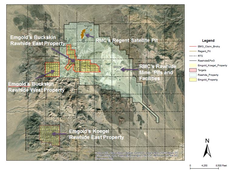
Buckskin Rawhide West is adjacent to the Regent Property. The Regent Property was acquired by RMC in January, 2013 (source: Pilot Gold Corporation press release dated January 10, 2013). The Regent Property was explored by Kennecott Exploration and Newmont Mining Corporation in the 1980’s and 1990’s with over 580 shallow reverse circulation drill holes drilled. This drilling was used by Kennecott to define a mineral resource that would be considered non NI 43-101 compliant by today’s standards. Pilot Gold acquired the Regent Property in 2011 and conducted additional exploration, including reverse circulation drilling, prior to selling the property to RMC. RMC is currently completing and Environmental Impact Statement (“EIS”) to permit mining of this resource as a satellite open pit operation of the Rawhide Mine.
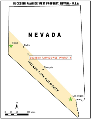
Buckskin Rawhide West
Location Map
Emgold also has the Buckskin Rawhide East Property which is located approximately one mile to the east of Buckskin Rawhide West. The two properties are separated by the RMC’s Regent Property. Buckskin Rawhide East is leased to RMC, who are conducting exploration with the goal of delineating additional resources that may, subject to exploration success, permitting success, and other factors, become potential satellite deposits of the Rawhide Mine.
Emgold management views Buckskin Rawhide West as a strategic acquisition, given its vicinity to Rawhide Mine and other known targets on the Regent and Buckskin Rawhide East Properties. However, the proximity of the Buckskin Rawhide West Property to other exploration or mining properties in the area does not mean a resource will be identified or delineated on the Property or satellite deposits will ultimately be brought into production. However, Emgold management believes the presence of similar geology and structures on the various properties does increase the potential for exploration success at Buckskin Rawhide West.
LOCATION AND OWNERSHIP
The Property is located approximately 40 miles southeast of Fallon, in Mineral County, Nevada, as shown on the Property Location Map. It is in the Rawhide Mining District (formerly known as the Regent Mining District). It is located three miles west of the Rawhide Mine, one mile west of the Buckskin Rawhide East Property, and adjacent to the Regent Property.
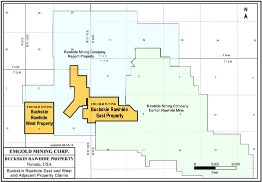
Buckskin Rawhide West
Location of Adjacent Properties
The Buckskin Rawhide West Property consists of 21 unpatented mineral lode claims totaling 420 acres, under the jurisdiction of the BLM. The claims are 100% owned by Emgold and were acquired from Jeremy C. Wire, an individual, located in San Jose, California.
Buckskin Rawhide West
Claim Map
The terms of this agreement with Jeremy Wire were disclosed in Emgold’s February 6, 2012 press release. Emgold agreed to lease, with the option to acquire, the Property from Mr. Wire under the following terms as shown in Table 1 below.
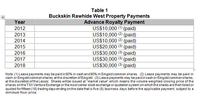
During the lease period, Emgold could conduct exploration and, if warranted, complete a NI 43-101 Technical Report on the Property. On making the above payments. Emgold had the option acquire 100% ownership of the property, which was exercised. Upon commercial production Jeremy Wire will be entitled to a 2 percent Net Smelter Royalty on production from the property. Emgold will retain the right to purchase this royalty for $1 million, less any advance royalty payments already made.
HISTORIC EXPLORATION AND MINING ACTIVITIES BY OTHERS
Gold was originally discovered on the Rawhide District in the year 1906. A gold rush in the area led to a number of mining claims being staked, ultimately forming the Regent Mining District (now known as the Rawhide Mining District). The gold rush led to the formation of the town of Rawhide, which grew to a population of 7,000 by 1908, falling back to 500 by the year 1910. By the 1940’s, the town was essentially abandoned.
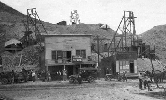
Buckskin Rawhide West
Town of Rawhide, Circa 1915
The Rawhide District was active with mining from 1908-1920, during which time 46,218 fine ounces of gold and 685,901 fine ounces of silver were reportedly produced from the historic mines in the District. From 1921 through 1935, only 2,815 fine ounces of gold and 51,463 fine ounces of silver were reportedly produced from the Rawhide Mining District (Vanderburg, 1937).
Modern exploration at in the Rawhide District, including the Buckskin Rawhide West Property, appears to have begun in 1982. Exploration activities consisted of geologic and alteration mapping, surface rock chip geochemical sampling, geophysics, and reverse circulation drilling, most of which was done by Kennecott Exploration Company. At that time, Kennecott was exploring the entire Rawhide District, eventually discovering and developing the Rawhide Mine. Other companies also conducted reconnaissance exploration in the area.
Modern mining in the Rawhide Mining District began in 1988 with the startup of Kennecott Minerals Company’s Rawhide Mine. The Rawhide Mine was located near the historic town of Rawhide which was where the greatest concentration of historic mine workings had existed. Rawhide Mine was historically owned and operated by Kennecott Minerals Company from 1988 to 2010. Operations at the mine were suspended in May 2003 due to low gold prices but the mine continued to produce gold from existing heap leach pads. In 2010, the Rawhide Mine was acquired by RMC who continued to produce gold from the heap leach pads. In 2012, RMC recommenced mining activities at the mine. The Denton-Rawhide Mine is reported to have produced 1.7 million ounces of gold and 14.1 million ounces of silver from 1990 through 2014 (Source: Nevada Bureau of Mines and Geology Special Publication MI-2014). Buckskin Rawhide West is located three miles west of the Rawhide Mine.
Buckskin Rawhide West is adjacent to the Regent Property. The Regent Property was acquired by RMC in January, 2013 (source: Pilot Gold Corporation press release dated January 10, 2013). The Regent Property was explored by Kennecott Exploration and Newmont Mining Corporation in the 1980’s and 1990’s with over 580 shallow reverse circulation drill holes drilled. This drilling was used by Kennecott to define a small mineral resource that would be considered non NI 43-101 compliant by today’s standards. Pilot Gold acquired the Regent Property in 2011 and conducted additional exploration, including reverse circulation drilling, prior to selling the property to RMC. RMC is currently completing and Environmental Impact Statement (“EIS”) to permit mining of these resource as a satellite operation of the Rawhide MIne.
Emgold also has the Buckskin Rawhide East Property which is located approximately one mile to the east of Buckskin Rawhide West. The two properties are separated by the RMC’s Regent Property. Buckskin Rawhide East is leased to RMC, who are conducting exploration with the goal of delineating additional resources that may, subject to exploration success, permitting success, and other factors, become potential satellite deposits of the Rawhide Mine. Kennecott Exploration drilled 80 reverse circulation drill holes on Buckskin Rawhide East in the 1980’s and 1990’s. RMC drilled additional holes on the property in 2013.
Emgold management views Buckskin Rawhide West as a strategic acquisition, given its vicinity to Rawhide Mine and other known targets on the Regent and Buckskin Rawhide East Properties. However, the proximity of the Buckskin Rawhide West Property to other exploration or mining properties in the area does not mean a resource will be identified or delineated on the Property or satellite deposits ultimately brought into production. However, management believes the presence of similar geology and structures on the various properties does increase the potential for exploration success at Buckskin Rawhide West.
GEOLOGY AND MINERALIZATION
The Buckskin Rawhide West Property is a volcanic-hosted, structurally controlled, epithermal gold-silver target situated in the Walker Lane gold belt of western Nevada. The Walker Lane is a regional shear zone and known gold trend that has hosted large and small historic and recent gold-silver mines in western Nevada, including mines of the Comstock Lode, Tonopah District and Rawhide District. From 1981 through 2009, mines located in Mineral County that were situated in the Walker Lane gold trend have produced 2,800,448 ounces of gold and 56,112,442 ounces of silver (Muntean, 2010). Property geology and mineralization is similar to RMC’s Rawhide Mine. Mineralization is associated with structures from the Walker Lane along with lithologic units and structures of the Rawhide volcanic center.
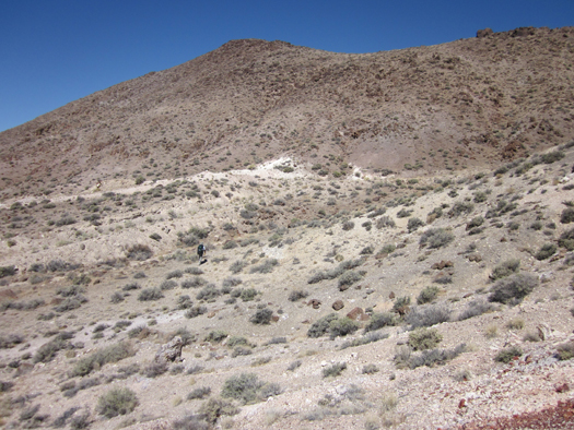
Buckskin Rawhide West
Property Looking North
EMERGENT’S EXPLORATION ACTIVITIES AT BUCKSKIN RAWHIDE WEST
To date, Emgold’s exploration activities at Buckskin Rawhide West have been limited to geological reconnaissance, geological mapping, and rock chip sampling. The Property is at the grass roots exploration stage.
DISTRICT EXPLORATION POTENTIAL
The Rawhide Mine, the Buckskin Rawhide East Property, and the Regent Property, are all indications of the exploration potential of the Rawhide Mining District and the potential for discovery of bulk disseminated and high grade vein mineral deposits. Other properties exist with known gold and silver mineralization in the District and the Walker Lane, as shown in the above map.
The Rawhide Mine represents the largest producing mine in the Rawhide District to date. Several exploration targets have been identified in the vicinity of Denton Rawhide Mine and synergy may exist to developed these targets as satellite deposits of the Mine. However, potential exists for discovery stand alone exploration targets that could be developed independently of Denton Rawhide Mine.
While exploration success at the Rawhide or Regent properties does not guarantee success at Buckskin Rawhide West, it does indicate the potential of the Rawhide District for gold-silver discoveries. There may ultimately be potential synergy for exploration, discovery, and development of the properties, given their close proximity. There may also be potential to expand the Buckskin Rawhide West Property or acquire other properties in the area.

Buckskin Rawhide West
Gold and Silver Properties
in the Walker Lane Gold Belt
RESOURCES AND RESERVES
Buckskin Rawhide West is an early stage exploration property. No NI 43-101 compliant resources have been defined for the property at this time.
MINING
If a resource is delineated by exploration on the Property, the potential might exist for mining of high grade vein zones and bulk mineable disseminated gold targets using either open pit or underground mining methods. Selection of mining methods would be subject to additional exploration activity, mining planning and engineering studies, and economic studies.
METALLURGY
If a resource is delineated by exploration on the Property, heap leaching of low grade ore or milling of higher grade ore would be evaluated. RMC operates a heap leach operation at the adjacent Rawhide Mine. Selection of a metallurgical process would be subject to additional exploration activity, metallurgical test work, and economic studies.
PERMITTING AND ENVIRONMENTAL
The Property is currently an exploration stage project and permits for drilling will be administered by BLM in Carson City, Nevada. Permits for small drilling programs disturbing less than five acres typically can be obtained in about 30 days, although the time can be longer depending on the work load of BLM staff at the time of application. Large programs requiring an Environmental Assessment would take several months to as much as a year, depending on the size and scope of the project.
The Buckskin Rawhide West Property does not appear to be situated close to any restricted areas (such as BLM wilderness areas). The Walker Lake Indian Reservation is situated approximately one mile west of the Buckskin Rawhide West claim block.
The State of Nevada is considered to be one of the best jurisdictions in the world for permitting mining operations. Permitting of a mining operation would be done under the National Environmental Policy Act (NEPA).
CONCLUSIONS
The Buckskin Rawhide West Property is a strategically located property given it location to the Rawhide Mine, Regent Property, and Buckskin Rawhide East Properties, all of which have similar geological structures and mineralogy. That being said, being located adjacent to these adjacent properties does not guarantee exploration success.
Initial exploration on the Property is planned to define potential mineralized areas for drill targets. The goal would ultimately be to define mineral resources on the Buckskin Rawhide West Property that would have potential to be mined at the adjacent Rawhide Mine. Should exploration be successful and such resources be defined, potential would exist to fast track permitting and development of these resources as satellite deposits to the Denton Rawhide Mine. This strategy has the potential to bring cash flow to Emgold in the shortest possible time-frame. Alternatively, the Property could be developed as a stand alone project.
QUALIFICATION
Emgold’s Qualified Person, Mr. Robert Pease CPG, Chief Geologist of the Company, has reviewed and approved the information on this webpage.
REFERENCES
Muntean, J. L., 2010, Major Precious-Metal Deposits, in the Nevada Mineral Industry 2009: Nevada Bureau of Mines and Geology Special Publication MI-2009.
Muntean, J.L., et. al, 2014, Nevada Bureau of Mines and Geology Special Publication MI-2012.
Vanderburg, W. O., 1937, Reconnaissance of Mining Districts in Mineral County, Nev.: Dept. of the Interior United States Bureau of Mines Information Circular 6941.
DISCLAIMER
Readers are cautioned to review the Disclaimer Page on this website for qualifications that may be applicable to the information contained on this Project Page, including Forward Looking Statements.