
| Location | Nevada |
| Location Details | 45 miles SE of Fallon |
| Type of Project | Early stage exploration |
| Number of Claims | 36 unpatented claims |
| Est. Property Size | 720 ac |
| Emgold Ownership | 100% |
| Underlying Royalties | 2% NSR, which can be purchased by Emgold for US$1 million, less advance royalties paid to date |
| Exploration Completed | Soil and rock chip sampling |
| Key Exploration Targets | T-10 high grade zone |
| Technical Report | None |
| Resources | None yet defined |
| Highlights | Located 5 miles southwest of the operating Rawhide Mine which has produced 1.7M oz. of Au and 14.1M oz. of Ag between 1990-2014. T-10 high grade zone identified with 11 samples taken by Emgold with an ave. grade of 0.27 opt Au and 13 historic samples taken by others with an ave. grade of 0.52 opt Au. |
The Koegel Rawhide Property is 100% owned by Emgold Mining Corporation. It is located five miles southwest of Rawhide Mining LLC’s operating Rawhide Mine and four miles south of Emgold’s Buckskin Rawhide East and West Properties. It has potential for high grade vein and bulk disseminated gold and silver mineralization.
SUMMARY
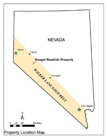
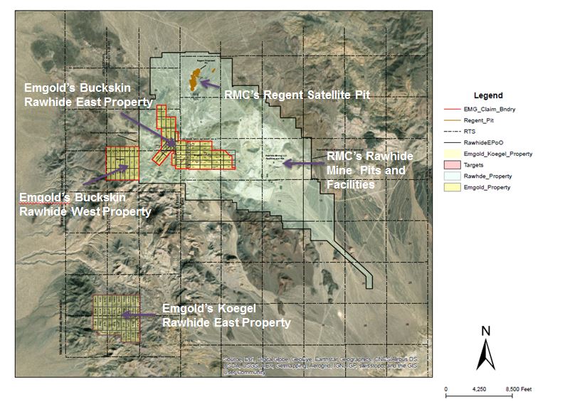
The Koegel Rawhide Property (“Koegel Rawhide” or the “Property”) is located approximately 45 miles southeast of Fallon, Nevada, in the Rawhide Mining District. It is in the Koegel Hills, about five miles southwest of Rawhide Mining LLC’s (“RMC”) Rawhide Mine and four miles south of Emgold’s Buckskin Rawhide East and West Properties.
The geology and mineralization of the Property is similar to the nearby n Rawhide Mine. Rawhide Mine was historically owned and operated by Kennecott Minerals Company from 1988 to 2010. Operations at the mine were suspended in May 2003 due to low gold prices but the mine continued to produce gold from existing heap leach pads. In 2010, the Rawhide Mine was acquired by Rawhide Mining LLC (“RMC”) who continued to produce gold from the heap leach pads. In 2012, RMC recommenced mining activities at the mine. The Rawhide Mine is reported to have produced 1.7 million ounces of gold and 14.1 million ounces of silver from 1990 through 2014 (Source: Nevada Bureau of Mines and Geology Special Publication MI-2014).
To date, exploration on the Property has consisted of grab and rock chip samples taken by former owners or by Emgold. Samples values range from non-detect to 1.99 ounces per ton gold from 464 historic samples and 14 Emgold samples. Exploration targets on the Property include high grade vein and bulk disseminated gold and silver mineralization. It is Emgold’s intent to continue exploration with the goal of ultimately developing an NI 43-101 compliant mineral resource on the Property.
Note that the location of the Property in the vicinity of the Rawhide Mine and other nearby exploration properties does not mean that a resource will be identified on the Property. However, the presence of similar geology and mineralized structures to those on the Buckskin Rawhide East and Rawhide Properties are favorable indicators for the potential of discovery.
Keogel Rawhide
Location Map
LOCATION AND OWNERSHIP
Koegel Rawhide is located approximately 45 miles southeast of Fallon, Nevada in the Rawhide Mining District. It is five miles southwest of the Rawhide Mine, which is owned and operated by RMC. The Property is also situated in the Koegel Hills, four miles south of Emgold’s Buckskin Rawhide East Property.
The Koegel Rawhide Property consists of 36 unpatented lode mining claims totaling 720 acres. Nineteen of the 36 unpatented mining claims, totaling 380 acres, are were acquired through a lease and option to purchase agreement with Jeremy Wire, an individual. Information on that acquisition was disclosed in a February 13, 2012 news release. The other 17 unpatented mining claims, totaling 340 acres, were staked by Emgold, as disclosed in a news release dated February 15. 2012.
Keogel Rawhide
Claim Map
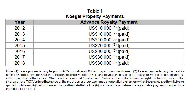
During the lease period for the 19 claims mentioned above, Emgold could conduct exploration and, if warranted, complete a NI 43-101 Technical Report on the Property. On making the payments shown in Table 1 below, Emgold had the option to acquire 100% ownership of the property (exercised in 2018). Upon commercial production Jeremy Wire will be entitled to a 2 percent Net Smelter Royalty on production from the property. Emgold will retain the right to purchase this royalty for $1 million, less any advance royalty payments already made.
Buckskin Rawhide West
Claim Map
HISTORY
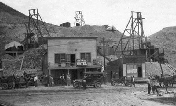
Gold was originally discovered on the Rawhide District in the year 1906. A gold rush in the area led to a number of mining claims being staked, ultimately forming the Regent Mining District (now known as the Rawhide Mining District). The gold rush led to the formation of the town of Rawhide, which grew to a population of 7,000 by 1908, falling back to 500 by the year 1910. By the 1940’s, the town was essentially abandoned.
Koegel Rawhide
Town of Rawhide, Circa 1915
The Rawhide District was active with mining from 1908-1920, during which time 46,218 fine ounces of gold and 685,901 fine ounces of silver were reportedly produced from the historic mines in the District. From 1921 through 1935, only 2,815 fine ounces of gold and 51,463 fine ounces of silver were reportedly produced from the Rawhide Mining District (Vanderburg, 1937).
Modern exploration at in the Rawhide District appears to have begun in 1982. Exploration activities consisted of geologic and alteration mapping, surface rock chip geochemical sampling, geophysics, and reverse circulation drilling, most of which was done by Kennecott Exploration Company. At that time, Kennecott was exploring the entire Rawhide District, eventually discovering and developing the Rawhide Mine. Other companies also conducted reconnaissance exploration in the area.
Modern mining in the Rawhide Mining District began in 1988 with the startup of Kennecott Minerals Company’s Rawhide Mine. The Rawhide Mine was located near the historic town of Rawhide which was where the greatest concentration of historic mine workings had existed. Rawhide Mine was historically owned and operated by Kennecott Minerals Company from 1988 to 2010. Operations at the mine were suspended in May 2003 due to low gold prices but the mine continued to produce gold from existing heap leach pads. In 2010, the Rawhide Mine was acquired by RMC who continued to produce gold from the heap leach pads. In 2012, RMC recommenced mining activities at the mine. The awhide Mine is reported to have produced 1.7 million ounces of gold and 14.1 million ounces of silver from 1990 through 2014 (Source: Nevada Bureau of Mines and Geology Special Publication MI-2014). Koegel Rawhide is located five miles southwest of the Rawhide Mine.
Koegel Rawhide is also about five miles south of the Regent Property. The Regent Property was acquired by RMC in January, 2013 (source: Pilot Gold Corporation press release dated January 10, 2013). The Regent Property was explored by Kennecott Exploration and Newmont Mining Corporation in the 1980’s and 1990’s with over 580 shallow reverse circulation drill holes drilled. This drilling was used by Kennecott to define a small mineral resource that would be considered non NI 43-101 compliant by today’s standards. Pilot Gold acquired the Regent Property in 2011 and conducted additional exploration, including reverse circulation drilling, prior to selling the property to RMC. RMC is currently completing and Environmental Impact Statement (“EIS”) to permit mining of these resource as a satellite operation of the Rawhide Mine.
Koegel Rawhide is about four miles south of Emgold’s Buckskin Rawhide East Property and West Properties. Buckskin Rawhide East is leased to RMC, who are conducting exploration with the goal of delineating additional resources that may, subject to exploration success, permitting success, and other factors, become potential satellite deposits of the Denton Rawhide Mine. Kennecott Exploration drilled 80 reverse circulation drill holes on Buckskin Rawhide East in the 1980’s and 1990’s. RMC drilled additional 22 reverse circulation holes on the property in 2013.
Emgold management views Koegel Rawhide as a strategic acquisition, given its vicinity to Rawhide Mine and other known targets on the Regent and Buckskin Rawhide East Properties. However, the proximity of the Koegel Rawhide Property to other exploration or mining properties in the area does not mean a resource will be identified or delineated on the Property or deposits ultimately brought into production. However, management believes the presence of similar geology and structures on the various properties does increase the potential for exploration success at Keogel Rawhide.
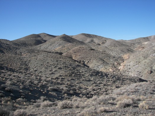
Koegel Rawhide
View Looking East
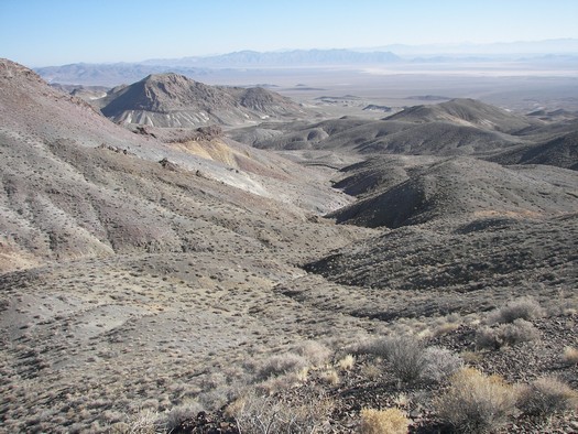
Koegel Rawhide
View Looking Northwest
GEOLOGY AND MINERALIZATION
Regional Geology
Koegel Rawhide is a volcanic-hosted, structurally controlled, epithermal gold-silver prospect in the Walker Lane gold belt of western Nevada. The Walker Lane is a regional shear zone and known gold trend that hosts large and small historic and currently operating gold-silver mines, including mines of the Comstock Lode, Tonopah District and Rawhide District. From 1981 through 2009, mines located in Mineral County that were situated in the Walker Lane gold trend have produced 2.8 million ounces of gold and 56.1 million ounces of silver (Muntean, 2010).
Koegel Rawhide geology and mineralization are associated with lithologic units and structures of the Rawhide volcanic center, as well as structures from the Walker Lane and Basin and Range. The geology and mineralization is similar to the nearby Rawhide Mine, Regent Property, and Emgold’s Buckskin Rawhide Property.
Property Geology
Geologic mapping by Charles P. Watson, a consulting geologist, completed in the years 1991-1992, indicates the area is covered mostly by Tertiary (Pliocene) age intermediate volcanic rocks including andesitic tuff breccias, sills and dikes. The volcanic units have been folded into minor anticlines and faulted. Faults of several orientations occur on the Property with north, northwest and northeast trends. Hydrothermal alteration (clay and silica) is present and is associated with structures and mineralization.
Mineralization
Gold and silver mineralization is known to be present at Koegel Rawhide, based on historic surface sampling, and appears to be structurally controlled and associated with faults and shear zones. Both high grade vein and bulk disseminated gold and silver mineralization has been identified.
HISTORIC EXPLORATION BY OTHERS
Gold and silver mineralization is known to be present at Koegel Rawhide, based on historic randomly spaced surface sampling on the Property. A total of 464 chip and grab samples were taken in geologically derived locations by consulting geologist Charles P. Watson in the years 1991-1992. The average gold grade of these historic samples is shown in Table 2, below:
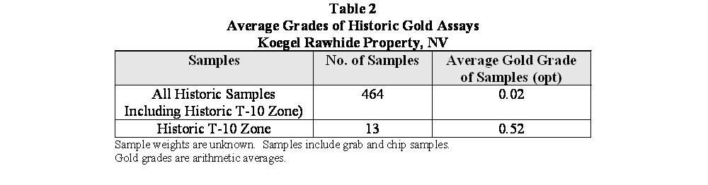
The results of the historic grab samples on the Property ranged from non-detectable to 1.99 ounce per ton gold, with 98 percent of those samples having gold grades less than 0.10 ounces per ton gold and two percent being greater than 0.10 ounces per ton gold. The sampling indicates the potential for both high grade vein and low grade bulk disseminated gold and silver mineralization.
Watson identified the T-10 Zone as one of the potential mineralized high grade vein structures. Historic sampling in the T-10 high grade area included 13 samples ranging in grades from 0.004 to 1.99 ounce per ton gold, with an average grade of 0.52 ounces per ton gold. Dimensions of the zone have not been defined, although the exposure sampled has a width of approximately eight feet. The area is open for expansion in several directions, and the true width of the structure is unknown at this time.
The methods and quality control from the historic sampling are unknown and cannot be verified. They are similar to modern sampling and the results are useful guides for further exploration.
EXPLORATION BY EMERGENT
Emgold’s surface samples were taken in areas of known mineralization on the Property, based on historic sampling done by Mr. Watson. The sampling was intended to confirm historic gold grades as part of due diligence work associated with the acquisition of the property and focused on high grade vein targets.
Ten rock chip-channel samples, each 12 inches in length, and four grab samples were taken from outcrops of bedrock and structures. The average gold grade of all samples is shown in Table 3. Dry sample weights varied from one to two pounds.
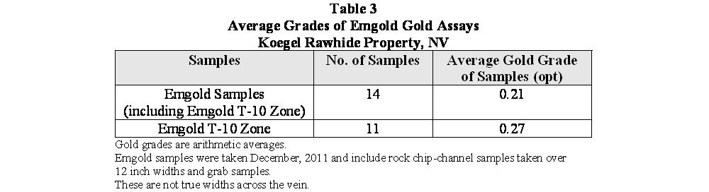
Emgold’s sampling results ranged from non-detectable to 1.60 ounces per ton gold, with 79 percent of the samples having gold grades less than 0.10 ounce per ton gold. Twenty-one percent had grades greater than 0.10 ounce per ton gold. Note that the average of Emgold’s 14 gold assays, as shown in Table 2, are higher than the average from the 464 samples historically assayed on the Property, and shown in Table 1. This is because most of Emgold’s samples were taken from known higher grade mineralized structures and did not evaluate bulk disseminated targets.
Emgold specifically sampled the T-10 high grade area, with results shown in Table 2. The grade of the 11 samples taken in the T-10 Zone ranged between non-detectable and 1.60 ounce per ton gold. The average grade was 0.27 opt gold. Results of Emgold’s sampling compared favorably with historic sampling on the Property.
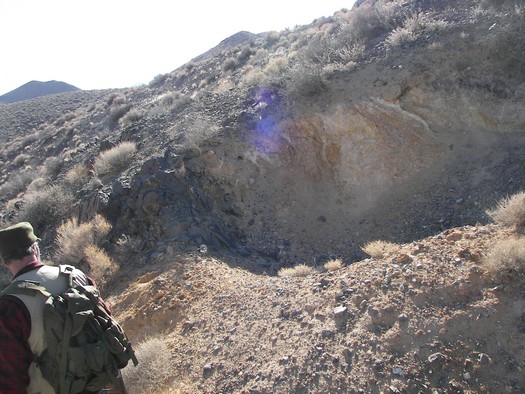
Koegel Rawhide
T-10 Zone Looking South
EMERGENT’S QUALITY ASSURANCE AND QUALITY CONTROL PROGRAM
Emgold’s quality assurance program and quality control measures at Koegel Rawhide pertained to all Emgold samples taken on the Property. Quality control measures included representative sampling, proper numbering, and accurately locating samples in the field both visually on maps and also with a GPS instrument. Samples were transported by the geological staff from the field to Emgold’s office-warehouse facility to assure secure storage, and were then packaged for shipment to the assay laboratory. Samples were shipped by Emgold employees or via commercial carriers directly to the assay laboratory for analysis.
Samples taken by Emgold were analyzed using standard methods. Emgold’s Qualified Person Mr. Robert Pease, Chief Geologist of the Company, visited the assay laboratory to review the general sample handling and preparation measures, to make sure they were adequate.
The assay laboratory cataloged all samples, maintained complete chain of custody throughout the analytical process, and electronically mailed the chain of custody forms to Emgold for review prior to initiating sample preparation. All sample preparation was done at the laboratory by their staff. As part of their quality assurance, the laboratory incorporated assaying standards, test blanks, and duplicate analyses of samples, and included those results in final reports. The final signed reports completed the chain of custody process. Thus far, no factors have been detected in any sampling programs conducted by Emgold on the Koegel Rawhide property that would materially affect the accuracy or reliability of Emgold’s sample data.
Mr. Robert Pease, Chief Geologist of the Company and a Qualified Person as defined in National Instrument 43-101, participated in and directly supervised the sampling program and interpreted historic data.
RESOURCES AND RESERVES
Koegel Rawhide is an early stage exploration property. No NI 43-101 compliant resources have been defined for the property at this time.
MINING
If an economically viable resource is found, the the property might be evaluated for possible mining of high grade vein zones and bulk mineable disseminated gold targets using either open pit or underground mining methods. Selection of mining methods would be subject to additional exploration activity and economic studies.
METALLURGY
No metallurgical work has been done to date on samples from the Property.
PERMITTING AND ENVIRONMENTAL
The Property is currently an exploration stage project and permits for drilling will be administered by BLM in Carson City, Nevada. Permits for small drilling programs disturbing less than five acres typically can be obtained in about 30 days, although the time can be longer depending on the work load of BLM staff at the time of application. Large programs requiring an Environmental Assessment would take several months.
The Koegel Rawhide Property does not appear to be situated close to any restricted areas (such as BLM wilderness areas). However, the Walker Lake Indian Reservation is situated approximately one mile west of the claims.
The State of Nevada is considered to be one of the best jurisdictions in the world for permitting mining operations. Permitting of a mining operation would be done under the National Environmental Policy Act (NEPA).
CONCLUSIONS
Koegel Rawhide is a favorable exploration property for Emgold because mineralization is present and because the geology and mineral deposition is similar to that found at the Rawhide Mine, a large and successful gold mine located nearby. Prior prospecting has delineated areas that can be prepared for further testing in a short time-frame and with minimal cost.
The Property not only represents a favorable exploration property, but also a strategic opportunity, being located near the active Rawhide Mine and other exploration properties.
The development strategies include advancing the Koegel Rawhide Property as a stand alone gold/silver exploration project, developing it in conjunction with Emgold’s nearby Buckskin Rawhide East and West Properties, or alternatively (and subject to agreements with other companies), combining Koegel Rawhide with other existing properties in the area to with the goal of creating a larger combined resource.
QUALIFICATION
Emgold’s Qualified Person, Mr. Robert Pease CPG, Chief Geologist of the Company, has reviewed and approved the scientific and technical information on this webpage.
REFERENCES
Muntean, J. L., 2010, Major Precious-Metal Deposits, in The Nevada Mineral Industry 2009: Nevada Bureau of Mines and Geology Special Publication MI-2009.
Vanderburg, W. O., 1937, Reconnaissance of Mining Districts in Mineral County, Nev.: Dept. of the Interior United States Bureau of Mines Information Circular 6941.
DISCLAIMER
Readers are cautioned to review the Disclaimer Page on this website for qualifications that may be applicable to the information contained on this Project Page, including Forward Looking Statements.