PROPERTY OVERVIEW
| LOCATION | 40 mi southeast of Fallon, NV |
| TYPE OF PROJECT | Early stage exploration |
| NUMBER OF CLAIMS | 21 unpatented claims |
| PROPERTY SIZE | 420 ac |
| OWNERSHIP | 100% owned by Emgold |
| PROPERTY STATUS | Available for sale or option |
| UNDERLYING ROYALTIES | 2% NSR, which can be purchased for US$1 million, less any advance royalties paid |
| EXPLORATION COMPLETED |
|
| KEY EXPLORATION TARGETS |
|
| NI 43-101 TECHNICAL REPORT | None completed to date |
| MINERAL RESOURCES | None defined to date |
| EXPLORATION HIGHLIGHTS |
|
INTRODUCTION
The Buckskin Rawhide West Property (“Buckskin Rawhide West” or the “Property”) is an early stage gold and silver exploration property located in the Walker Lane Gold Belt in the Rawhide Mining District, Mineral County, Nevada. It is located west and adjacent to Rawhide Mining LLC’s (“RMC”) operating Rawhide Mine (aka Denton Rawhide Mine).
Gold was originally discovered at Rawhide, NV in 1906. In the 1980’s, Kennecott Exploration Company consolidated a large land package and, in 1988, Kennecott Minerals Company developed the Rawhide Mine. As of 2018, the latest available public data, Rawhide Mine has produced 1.7 million ounces of gold and 16.5 million ounces of silver (Nevada Bureau of Mines).
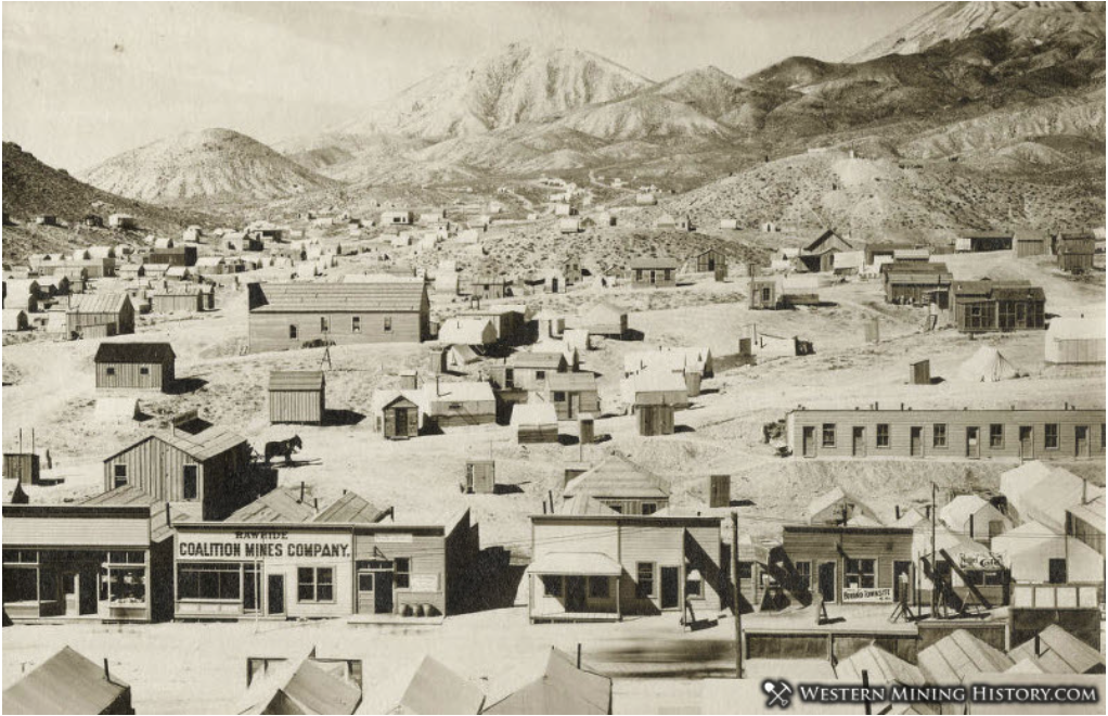
Town of Rawhide, NV Circa 1908
(source: westernmininghistory.com)
Note that the location of the Property in the vicinity of Rawhide Mine or other nearby mineral properties does not guarantee exploration success or that mineral resources or reserves will be delineated at Buckskin Rawhide West.
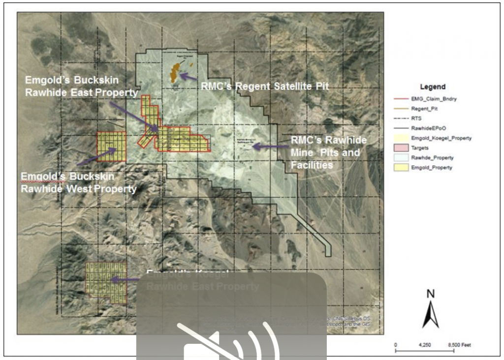
The Property is a strategically held property that is adjacent to a large bulk disseminated exploration target that occurs on the adjacent Rawhide Mine Property and Emergent's Buckskin Rawhide East Property (leased to RMC). Potential exists for this target to overlap onto the Buckskin Rawhide West Property, subject to exploration success. Several NE-SW trending structures have been mapped on the Property that appear to trend toward the Regent open pit on the adjacent Rawhide Mine Property. RMC recently began mining at the Regent deposit, and has plans to conduct exploration drilling on Emergent's Buckskin Rawhide East Property.
LOCATION & OWNERSHIP
The Property is located approximately 40 miles southeast of Fallon, NV in the north end of the Koegel Hills. It is three miles west of the Rawhide Mine facilities and two miles southwest of RMC’s newly permitted Regent satellite open pit. It is one mile west of Emergent's Buckskin Rawhide East Property, leased to and being explored by RMC.
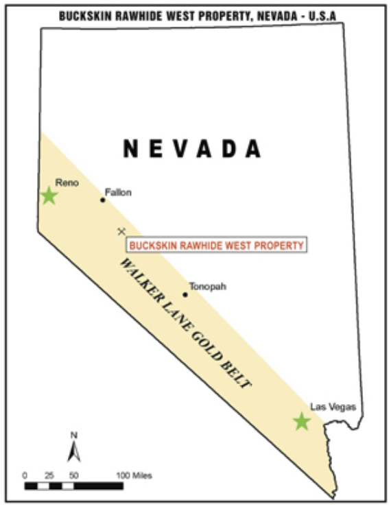
Buckskin Rawhide West Property
Location Map
Buckskin Rawhide Property
(Location West of Rawhide Mine
And Emergent's Buckskin Rawhide East Property)
Emgold originally optioned the Buckskin Rawhide West Property from Jeremy Wire under a lease and option to purchase agreement (see February 6, 2012 news release). The Property consists of 21 unpatented claims totaling 420 acres.
Emgold made advance royalty payments of US$140,000 from 2012 and 2018 and exercised its option to acquire the Property. Jeremy Wire retains a 2% Net Smelter Royalty (“NSR”) on the Property that Emgold has the option of acquiring for US$1.0 million, less any advance royalty payments already made.
GEOLOGY & MINERALIZATION
The Property is a volcanic-hosted, structurally controlled, epithermal gold-silver target situated in the Walker Lane gold belt of western Nevada. The Walker Lane is a regional shear zone and known gold trend that has hosted large and small historic and recent gold-silver mines in western Nevada, including mines of the Comstock Lode, Tonopah District and Rawhide District. From 1981 through 2009, mines located in Mineral County that were situated in the Walker Lane gold trend produced 2,800,448 ounces of gold and 56,112,442 ounces of silver (Muntean, 2010).
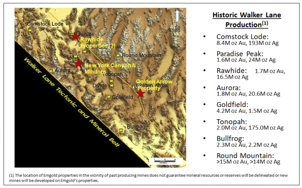
Emgold Properties and Historic
Walker Lane Gold Production
Property geology and mineralization is similar to the nearby Rawhide Mine, and Emergent's Buckskin Rawhide East Property. Mineralization is associated with structures from the Walker Lane and the Basin and Range along with lithologic units and structures of the Rawhide volcanic center.
The geology of the Property includes the volcanic lithologies of andesite and latite juxtaposed along a north-northeast trending fault with opalite situated along the contact. Several mapped faults trend north to northeast, and faults inferred from a historic ground magnetics geophysical traverse trend northwest.
Jeremy Wire, a hydrogeologist and the prior claimant, concluded that two hydrothermal environments exist on the Property: the first being a high level opalite plus acid-leached zone, and the second being a deeper zone of alteration. Wire felt that the alteration environment fit a low sulfidation model whereby the opalite was deposited at a paleo water table and acid-leaching of the rocks occurred. Emergent's preliminary interpretation is that this might be the top of a geothermal system.
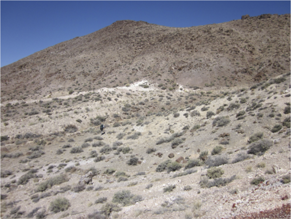
Buckskin Rawhide West Property
Alteration Zone Looking West
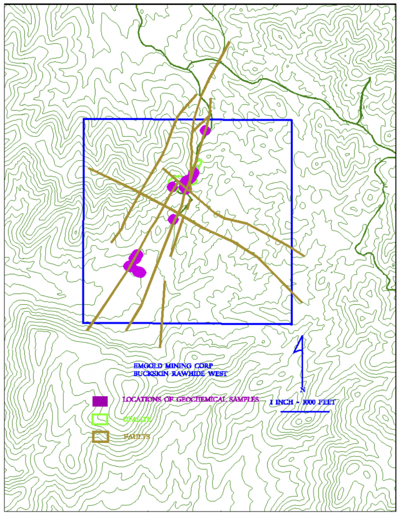
Buckskin Rawhide West Property
Structure and Sample Map
EXPLORATION
Gold was originally discovered on the Buckskin Rawhide claims in the year 1906. A gold rush in the area led to a number of mining claims being staked, ultimately forming the Regent Mining District (now known as the Rawhide Mining District). The gold rush led to the formation of the town of Rawhide, which grew to a population of 7,000 by 1908, and declined to 500 by the year 1910. By the 1940’s, the town was essentially abandoned.
The Rawhide District was active with mining from 1908-1920, during which time 46,218 fine ounces of gold and 685,901 fine ounces of silver were produced from the historic mines. From 1921 through 1935, only 2,815 fine ounces of gold and 51,463 fine ounces of silver were produced from the Rawhide Mining District (Vanderburg, 1937).
Modern exploration in the Rawhide area appears to have begun in the 1980’s, most of which was done by Kennecott Exploration Company. At that time, Kennecott was exploring the entire Rawhide District, eventually discovering and developing the Rawhide Mine, which Kennecott Minerals Company and others have operated from 1988 to present. However, they apparently did not explore the Buckskin Rawhide West Property.
Historic exploration of the Property included geologic mapping, reconnaissance rock chip sampling, a ground magnetics survey and a mercury soil gas geochemistry survey. Shallow historic prospects are also present, but information on these workings is unknown.
Reconnaissance geologic mapping, along with a ground magnetics survey run in 1989, determined the locations of structures that crossed the claim block. Historic surface rock geochemistry samples were taken in the years 1990 and 1992. The sample locations were associated with north to northeast-trending faults on the southwest quarter of the property. Several samples, taken in opalite breccias, assayed less than 50 ppb gold, but those rocks had elevated mercury and arsenic concentrations, all of which might be suggestive of a boiling zone in a geothermal system. In 2001 a soil sampling program was conducted by MEG, Inc. using low temperature mercury desorption. This study indicated that high mercury concentrations might be related to structures and subsurface mineralization on the Property.
The historic rock samples were assayed by Hunter Mining Laboratory, Inc. in August 1990 and Legend, Inc. in September 1992. Both of these were reputable and reliable assay laboratories at that time. Historic samples were taken prior to the implementation of NI 43-101 and CIM Standards for Disclosure, therefore quality assurance and quality control measures are unknown. They have not been verified by Emergent's geologist. However, the historic sample results did compare adequately with modern sampling done by Emgold in opalite rocks on the Property.
Emergent's exploration on the Property has been limited to reconnaissance geological mapping and rock chip sampling. The Property is at the grass roots exploration stage. However, it is strategically located and has potential for discovery. Note that the location of the Property adjacent to an operating mine or other exploration properties does not guarantee mineral resources and reserves will be delineated at Buckskin Rawhide West and currently no mineral resources or reserves have been delineated on the Property.
Emgold’s quality assurance program and quality control measures at Buckskin Rawhide West used for its sampling program included representative sampling, proper numbering, and accurately locating samples in the field both visually on maps and also with a GPS instrument. Samples were transported by the geological staff from the field to Emgold’s office-warehouse facility to assure secure storage, and were then packaged for shipment to the assay laboratory. Samples were shipped by Emgold employees or via commercial carriers directly to the assay laboratory for analysis. No factors were encountered in the sampling program conducted by Emgold on the Property that would materially affect the accuracy or reliability of Emergent's sample data or cause loss of confidence in the laboratory.
TECHNICAL REPORT
No Technical Report has yet been completed for the Property.
QUALIFICATIONS
Mr. Robert Pease, CPG, acting as the Qualified Person for Emgold, has reviewed and approved the information on this webpage.
REFERENCES
Muntean, J. L., 2010, Major Precious-Metal Deposits, in the Nevada Mineral Industry 2009: Nevada Bureau of Mines and Geology Special Publication MI-2009.
Nevada Bureau of Mines and Geology Special Publications (multiple years used to obtain Rawhide Mine production data).
Vanderburg, W. O., 1937, Reconnaissance of Mining Districts in Mineral County, Nev.: Dept. of the Interior United States Bureau of Mines Information Circular 6941.
DISCLAIMER
Readers are cautioned to review the Disclaimer Page on this website for qualifications that may be applicable to the information contained on this Property Page, including forward looking statements, definitions of mineral resources and reserves, etc. Readers are also cautions to review Emergent's financial statements and management’s discussion and analysis available on this website or at www.sedar.com for additional information.
PROPERTY OVERVIEW
| LOCATION | 40 mi southeast of Fallon, NV |
| TYPE OF PROJECT | Early stage exploration |
| NUMBER OF CLAIMS | 21 unpatented claims |
| PROPERTY SIZE | 420 ac |
| OWNERSHIP | 100% owned by Emgold |
| PROPERTY STATUS | Available for sale or option |
| UNDERLYING ROYALTIES | 2% NSR, which can be purchased for US$1 million, less any advance royalties paid |
| EXPLORATION COMPLETED |
|
| KEY EXPLORATION TARGETS |
|
| NI 43-101 TECHNICAL REPORT | None completed to date |
| MINERAL RESOURCES | None defined to date |
| EXPLORATION HIGHLIGHTS |
|
INTRODUCTION
The Buckskin Rawhide West Property (“Buckskin Rawhide West” or the “Property”) is an early stage gold and silver exploration property located in the Walker Lane Gold Belt in the Rawhide Mining District, Mineral County, Nevada. It is located west and adjacent to Rawhide Mining LLC’s (“RMC”) operating Rawhide Mine (aka Denton Rawhide Mine).
Gold was originally discovered at Rawhide, NV in 1906. In the 1980’s, Kennecott Exploration Company consolidated a large land package and, in 1988, Kennecott Minerals Company developed the Rawhide Mine. As of 2018, the latest available public data, Rawhide Mine has produced 1.7 million ounces of gold and 16.5 million ounces of silver (Nevada Bureau of Mines).
Town of Rawhide, NV Circa 1908
(source: westernmininghistory.com)
Note that the location of the Property in the vicinity of Rawhide Mine or other nearby mineral properties does not guarantee exploration success or that mineral resources or reserves will be delineated at Buckskin Rawhide West.
The Property is a strategically held property that is adjacent to a large bulk disseminated exploration target that occurs on the adjacent Rawhide Mine Property and Emergent's Buckskin Rawhide East Property (leased to RMC). Potential exists for this target to overlap onto the Buckskin Rawhide West Property, subject to exploration success. Several NE-SW trending structures have been mapped on the Property that appear to trend toward the Regent open pit on the adjacent Rawhide Mine Property. RMC recently began mining at the Regent deposit, and has plans to conduct exploration drilling on Emergent's Buckskin Rawhide East Property.
LOCATION & OWNERSHIP
The Property is located approximately 40 miles southeast of Fallon, NV in the north end of the Koegel Hills. It is three miles west of the Rawhide Mine facilities and two miles southwest of RMC’s newly permitted Regent satellite open pit. It is one mile west of Emergent's Buckskin Rawhide East Property, leased to and being explored by RMC.
Buckskin Rawhide West Property
Location Map
Buckskin Rawhide Property
(Location West of Rawhide Mine
And Emergent's Buckskin Rawhide East Property)
Emgold originally optioned the Buckskin Rawhide West Property from Jeremy Wire under a lease and option to purchase agreement (see February 6, 2012 news release). The Property consists of 21 unpatented claims totaling 420 acres.
Emgold made advance royalty payments of US$140,000 from 2012 and 2018 and exercised its option to acquire the Property. Jeremy Wire retains a 2% Net Smelter Royalty (“NSR”) on the Property that Emgold has the option of acquiring for US$1.0 million, less any advance royalty payments already made.
GEOLOGY & MINERALIZATION
The Property is a volcanic-hosted, structurally controlled, epithermal gold-silver target situated in the Walker Lane gold belt of western Nevada. The Walker Lane is a regional shear zone and known gold trend that has hosted large and small historic and recent gold-silver mines in western Nevada, including mines of the Comstock Lode, Tonopah District and Rawhide District. From 1981 through 2009, mines located in Mineral County that were situated in the Walker Lane gold trend produced 2,800,448 ounces of gold and 56,112,442 ounces of silver (Muntean, 2010).
Emgold Properties and Historic
Walker Lane Gold Production
Property geology and mineralization is similar to the nearby Rawhide Mine, and Emergent's Buckskin Rawhide East Property. Mineralization is associated with structures from the Walker Lane and the Basin and Range along with lithologic units and structures of the Rawhide volcanic center.
The geology of the Property includes the volcanic lithologies of andesite and latite juxtaposed along a north-northeast trending fault with opalite situated along the contact. Several mapped faults trend north to northeast, and faults inferred from a historic ground magnetics geophysical traverse trend northwest.
Jeremy Wire, a hydrogeologist and the prior claimant, concluded that two hydrothermal environments exist on the Property: the first being a high level opalite plus acid-leached zone, and the second being a deeper zone of alteration. Wire felt that the alteration environment fit a low sulfidation model whereby the opalite was deposited at a paleo water table and acid-leaching of the rocks occurred. Emergent's preliminary interpretation is that this might be the top of a geothermal system.
Buckskin Rawhide West Property
Alteration Zone Looking West
Buckskin Rawhide West Property
Structure and Sample Map
EXPLORATION
Gold was originally discovered on the Buckskin Rawhide claims in the year 1906. A gold rush in the area led to a number of mining claims being staked, ultimately forming the Regent Mining District (now known as the Rawhide Mining District). The gold rush led to the formation of the town of Rawhide, which grew to a population of 7,000 by 1908, and declined to 500 by the year 1910. By the 1940’s, the town was essentially abandoned.
The Rawhide District was active with mining from 1908-1920, during which time 46,218 fine ounces of gold and 685,901 fine ounces of silver were produced from the historic mines. From 1921 through 1935, only 2,815 fine ounces of gold and 51,463 fine ounces of silver were produced from the Rawhide Mining District (Vanderburg, 1937).
Modern exploration in the Rawhide area appears to have begun in the 1980’s, most of which was done by Kennecott Exploration Company. At that time, Kennecott was exploring the entire Rawhide District, eventually discovering and developing the Rawhide Mine, which Kennecott Minerals Company and others have operated from 1988 to present. However, they apparently did not explore the Buckskin Rawhide West Property.
Historic exploration of the Property included geologic mapping, reconnaissance rock chip sampling, a ground magnetics survey and a mercury soil gas geochemistry survey. Shallow historic prospects are also present, but information on these workings is unknown.
Reconnaissance geologic mapping, along with a ground magnetics survey run in 1989, determined the locations of structures that crossed the claim block. Historic surface rock geochemistry samples were taken in the years 1990 and 1992. The sample locations were associated with north to northeast-trending faults on the southwest quarter of the property. Several samples, taken in opalite breccias, assayed less than 50 ppb gold, but those rocks had elevated mercury and arsenic concentrations, all of which might be suggestive of a boiling zone in a geothermal system. In 2001 a soil sampling program was conducted by MEG, Inc. using low temperature mercury desorption. This study indicated that high mercury concentrations might be related to structures and subsurface mineralization on the Property.
The historic rock samples were assayed by Hunter Mining Laboratory, Inc. in August 1990 and Legend, Inc. in September 1992. Both of these were reputable and reliable assay laboratories at that time. Historic samples were taken prior to the implementation of NI 43-101 and CIM Standards for Disclosure, therefore quality assurance and quality control measures are unknown. They have not been verified by Emergent's geologist. However, the historic sample results did compare adequately with modern sampling done by Emgold in opalite rocks on the Property.
Emergent's exploration on the Property has been limited to reconnaissance geological mapping and rock chip sampling. The Property is at the grass roots exploration stage. However, it is strategically located and has potential for discovery. Note that the location of the Property adjacent to an operating mine or other exploration properties does not guarantee mineral resources and reserves will be delineated at Buckskin Rawhide West and currently no mineral resources or reserves have been delineated on the Property.
Emgold’s quality assurance program and quality control measures at Buckskin Rawhide West used for its sampling program included representative sampling, proper numbering, and accurately locating samples in the field both visually on maps and also with a GPS instrument. Samples were transported by the geological staff from the field to Emgold’s office-warehouse facility to assure secure storage, and were then packaged for shipment to the assay laboratory. Samples were shipped by Emgold employees or via commercial carriers directly to the assay laboratory for analysis. No factors were encountered in the sampling program conducted by Emgold on the Property that would materially affect the accuracy or reliability of Emergent's sample data or cause loss of confidence in the laboratory.
TECHNICAL REPORT
No Technical Report has yet been completed for the Property.
QUALIFICATIONS
Mr. Robert Pease, CPG, acting as the Qualified Person for Emgold, has reviewed and approved the information on this webpage.
REFERENCES
Muntean, J. L., 2010, Major Precious-Metal Deposits, in the Nevada Mineral Industry 2009: Nevada Bureau of Mines and Geology Special Publication MI-2009.
Nevada Bureau of Mines and Geology Special Publications (multiple years used to obtain Rawhide Mine production data).
Vanderburg, W. O., 1937, Reconnaissance of Mining Districts in Mineral County, Nev.: Dept. of the Interior United States Bureau of Mines Information Circular 6941.
DISCLAIMER
Readers are cautioned to review the Disclaimer Page on this website for qualifications that may be applicable to the information contained on this Property Page, including forward looking statements, definitions of mineral resources and reserves, etc. Readers are also cautions to review Emergent's financial statements and management’s discussion and analysis available on this website or at www.sedar.com for additional information.